This item has been sold, but you can get on the Waitlist to be notified if another example becomes available, or purchase a digital scan.
1933 Japanese Panorama Map of Nara, Japan
Nara-showa8-1933$125.00

Title
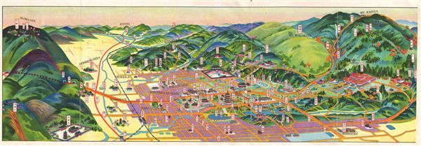
Nara.
1933 (dated) 7 x 20.5 in (17.78 x 52.07 cm)
1933 (dated) 7 x 20.5 in (17.78 x 52.07 cm)
Description
An uncommon Showa 8 or 1933 map and view of Nara Japan. This is one of the Japanese issue bi-lingual maps of any Japanese city to be issued before World War II. Shows city blocks, historic buildings, and rail lines. Nara (Nara-shi) is the capital city of Nara Prefecture in the Kansai region of Japan. The city occupies the northern part of Nara Prefecture, directly bordering Kyoto Prefecture. eight temples, shrines and ruins in Nara, specifically To-dai-ji, Saidai-ji, Ko-fuku-ji, Kasuga Shrine, Gango--ji, Yakushi-ji, To-sho-dai-ji and the Heijo- Palace remains, together with Kasugayama Primeval Forest, collectively form 'Historic Monuments of Ancient Nara,' a UNeSCO World Heritage Site.
This uncommon type of map evolved from the exposure of traditional Japanese view-style cartography to western technology. Views like this began to appear in Japan, Taiwan, and Korea in the early 20th century. Generally speaking such maps coincided with the development of railroad lines throughout the once vast Dai Nippon Teikoku or Japanese empire. It is a distinctive style full of artistic flourish that at the same time performs a practical function. This particular example is both relatively early and exceptionally beautiful. It was printed via a multi-color chromolithographic process with delicately shaded tones and an easily comprehensible intuitive design. essentially a transportation map, it shows the major and minor rail lines throughout Nara.
This uncommon type of map evolved from the exposure of traditional Japanese view-style cartography to western technology. Views like this began to appear in Japan, Taiwan, and Korea in the early 20th century. Generally speaking such maps coincided with the development of railroad lines throughout the once vast Dai Nippon Teikoku or Japanese empire. It is a distinctive style full of artistic flourish that at the same time performs a practical function. This particular example is both relatively early and exceptionally beautiful. It was printed via a multi-color chromolithographic process with delicately shaded tones and an easily comprehensible intuitive design. essentially a transportation map, it shows the major and minor rail lines throughout Nara.
Condition
Very good condition. Minor wear on original fold lines.