This item has been sold, but you can get on the Waitlist to be notified if another example becomes available, or purchase a digital scan.
1854 Pharoah Map or Plan of the City of Secunderabad, Telangana, India
Secunderabad-pharoah-1854$225.00

Title
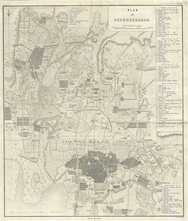
Plan of Secunderabad.
1854 (undated) 18 x 15.5 in (45.72 x 39.37 cm) 1 : 14400
1854 (undated) 18 x 15.5 in (45.72 x 39.37 cm) 1 : 14400
Description
This is a beautiful 1854 map or plan of Secunderabad located in the Indian state of Telangana. It covers the British cantonment in beautiful detail, noting streets, bazaar, military grounds, tanks, fields, streams, and topography. Extends from the Hussain Sagar Lake north to Bowenpally. The map includes six specific areas and a reference key along the right border lists the locations noted in each area. These include hospitals, burial grounds, military offices, cathedrals, cells, etc.
Separated from Hyderabad by the man made Hussain Sagar Lake, Secundarabad is often referred to as the twin city of Hyderabad. Founded as a British cantonment in 1806, the city developed directly under British rule until India’s independence. Today Secunderabad is part of the city of Hyderabad and continues to be one of the largest cantonments in India, with a large presence of army and air force personnel.
This map was engraved by J. and C. Walker and issued as plate no. 52 by Pharoah and Company in their 1854 Atlas of Southern India.
CartographerS
J. B. Pharoah (fl. c. 1838 – 1869) was a Madras, India, based bookseller and publisher of educational books and maps active in the middle of the 19th century. He maintained a bookshop on Mount Road. The form of which was a general emporium for European published work. They also published a weekly English language newspaper called The Athenaeum and Statesman (in 1864 renamed, The Athenaeum and Daily News). They also published the The Madras Quarterly Medical Journal and The Madras Journal of Literature and Science. More by this mapmaker...
John Walker (1787 - April 19, 1873) was a British map seller, engraver, lithographer, hydrographer, geographer, draughtsman, and publisher active in London during the 19th century. Walker published both nautical charts and geographical maps. His nautical work is particularly distinguished as he was an official hydrographer for the British East India Company, a position, incidentally, also held by his father of the same name. Walker's maps, mostly published after 1827, were primarily produced with his brothers Charles Walker and Alexander Walker under the imprint J. and C. Walker. Among their joint projects are more than 200 maps for the influential Society for the Diffusion of Useful Knowledge Atlas (SDUK). In addition they published numerous charts for James Horsburgh and the British Admiralty Hydrographic Office, including Belcher's important map of Hong Kong and Carless' exploratory map of Karachi. The J. and C. Walker firm continued to publish after both Walkers died in the 1870s. Learn More...
Source
Pharoah and Company, An Atlas of the Southern Part of India including Plans of all the Principal Towns and Cantonments, reduced from the Grand Trigonometrical Survey of India shewing also The Tenasserim Provinces, (Madras) 1854.
The Pharoah and Company Atlas of Southern India was published around 1854. The medium format 4to atlas contained some 70 maps focusing on the southern part of Indian and the Tanasserium Province, or Burma. The atlas was engraved an printed in London by J. and C. Walker, but seems to have been issued only in Madras, India, by J. B. Pharoah and Company. The atlas claims to have been "reduced from the Grand Trigonometrical Survey of India," and, in fact the survey did provide a framework for the atlas, but little of the actual cartographic detail. The atlas is rather novel in that it has universal scale of 16 miles to the inch (1 : 1013760) for most of its regional maps. In addition to its regional maps, the atlas also contained 21city plans. These plans are some of the only obtainable mid-195h century maps of many South Indian cities. It also contained a rare map of Singapore.
Condition
Very good. Minor foxing. Minor wear along original fold line.
References
OCLC: 712141709.