This copy is copyright protected.
Copyright © 2025 Geographicus Rare Antique Maps
1791 Faden Wall Map of Southern India
SouthernIndia-faden-1791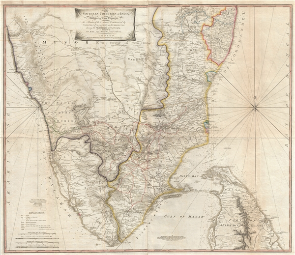

The regiments then went on to India, to take their part in the Second Anglo-Mysore War against Haidar Ali. Humberston 's regiment disembarked at Calicut, to make a diversion by invading Mysore from the Malabar coast, while Fullarton's went round to Madras. He remained in the neighborhood of the capital of the presidency until after the Battle of Porto Novo, when he was sent south in command of the king's troops, in order if possible to attract the Mysore troops away from the Carnatic. In June 1782 Fullarton was gazetted a colonel in the army for the East Indies, with Sir Robert Barker, Norman Macleod, John Floyd, and many others, in order to put an end to the perpetual disputes between the king's and the company's officers, and he co-operated in the winter campaign of 1782–3 in the suppression of the Kollars, the fighting tribes of Madura, and in the capture of Karur and Dindigal. Fullarton led the Madras Army against the rebel Kattaboman, a palaiyakarar of Panchalum Kurucchi, a fortress town in present day Tinnevelly District of Tamil Nadu. Fullarton's name is associated with the destruction of the fort of the rebel chieftain at Nettkelcheval, again in Tinnevelly District. In May 1783 he succeeded to the general command of all the troops south of the Coleroon, and on 2 June he took Dharapuram. He then advanced towards General James Stuart, who was besieging Cuddalore.This map is extremely rare. The OCLC cites only five examples in institutional collections. It appears to have been first issued in 1788, the present example being a slightly later edition dating to 1791. If anything, this second edition is much rarer than the first, with only 1 known example retained in the archives of the British Library.
On the news of the fall of that city, he determined to attack Pálghát, which had resisted all the efforts of Humberston in the previous year. He had to make his way through a dense forest. When he got through it, he had to storm the city. There, he heard that Tippoo Sultan, who had succeeded Haidar Ali on the throne, was not fulfilling the terms agreed to at the surrender of Mangalore, and Fullarton accordingly followed up his success by the capture of the fortress of Coimbatore. At this time, he was imperatively ordered to cease all hostilities by the government of Madras, and a sort of peace was patched up between the company and Tippoo Sultan.
William Faden (July 11, 1749 - March 21, 1836) was a Scottish cartographer and map publisher of the late 18th century. Faden was born in London. His father, William MacFaden, was a well-known London printer and publisher of The Literary Magazine. During the Jacobite Rebellion (1745 - 1746), MacFaden changed his family name to Faden, to avoid anti-Scottish sentiment. Faden apprenticed under the engraver James Wigley (1700 - 1782), attaining his freedom in 1771 - in the same year that Thomas Jefferys Sr. died. While Thomas Jefferys Sr. was an important and masterful mapmaker, he was a terrible businessman, and his son, Jefferys Jr., had little interest in building on his father's legacy. MacFaden, perhaps recognizing an opportunity, purchased his son a partnership in the Jefferys firm, which subsequently traded as 'Faden and Jefferys'. Jefferys Jr. also inherited Jefferys Sr.'s title, 'Geographer to the King and to the Prince of Wales'. With little interest in cartography or map publishing, Jefferys Jr. increasingly took a back seat to Faden, and by 1776, he had withdrawn from day-to-day management, although he retained his financial stake. The American Revolutionary War (1775 - 1783) proved to be a boom for the young 'Geographer to the King', who leveraged existing materials and unpublished manuscript maps to which he had access via his official appointment to publish a wealth of important maps, both for official use and the curious public - this period of prosperity laid the financial underpinning for Faden, who by 1783, at the end of the war, acquired full ownership of the firm and removed the Jefferys imprint. In 1801, he engraved and published the first maps for the British Ordnance Survey. By 1822, Faden published over 350 maps, atlases, and military plans. He retired in 1823, selling his plates to James Wyld Sr. Faden died in 1836. More by this mapmaker...
Copyright © 2025 Geographicus Rare Antique Maps | Geographicus Rare Antique Maps
This copy is copyright protected.
Copyright © 2025 Geographicus Rare Antique Maps