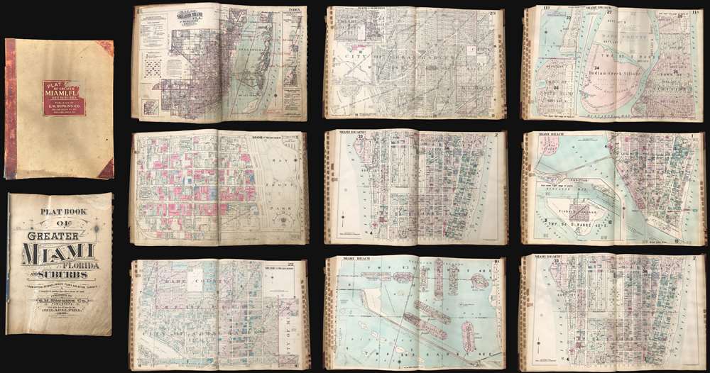
Title
Plat Book of Greater Miami Florida and Suburbs.
1940 (dated)
24.5 x 19 in (62.23 x 48.26 cm)
Description
This is an extraordinary and rare 1936 - 1940 G.M. Hopkins Company cadastral plat atlas of Miami and Miami Beach, Florida - as such chronicling the development of Miami's iconic art deco architecture. The atlas consists of 53 maps, 40 of Greater Miami and 15 of Miami Beach. Coverage is detailed and extensive, including downtown Miami, Coral Gables, Little Havana, Edgewater, the Art Deco District, Ocean Drive, the Lincoln Road Mall, Star Island, Venetian Island, Hibiscus Island, Palm Island, Belle Isle, Indian Creek, etc. The detail throughout is outstanding, naming theaters, office buildings, hotels, public utilities, private properties, golf courses, racetracks, and much much more. This atlas was designed for use by the insurance industry to help assess property risk and value. Moreover, the maps were intended to be updated and revised as properties changed with labeled cutout pastedowns. Most, if not all, of the maps in this atlas exhibit such changes, bringing the plat book current to roughly 1973.
Art Deco in Miami
This atlas chronicles the development the Art Deco buildings for which Miami Beach is most famous through the 1930s and 1940s. Art Deco was introduced to the world at the 1925 Exposition of Modern and Decorative Arts in Paris - just before construction in Miami Beach began in earnest. Miami's famous Art Deco district was built between 1823 and 1943 and today consists of more than 960 buildings, ranging from humble apartment buildings to grandiose waterfront hotels. Prominent Miami Art Deco architects of this period include Henry Hohauser and L. Murray Dixon. The Art Deco district of Miami was in danger of being demolished in the 1960s - 1970s but local activists and preservationists saved the district, registering it in 1979 as a U.S. Historic District. Today, the beachside city glows with whimsical pastel tones, porthole windows, striking geometric forms, flora and fauna motifs, bold curves, chrome, and terrazzo floors. Plat Maps
Cadastral plat or land ownership maps grew out of the techniques developed by the Public Land Survey System (PLSS), a cartographic strategy implemented to survey the 1787 Northwest Ordinance. The PLSS allowed for the systematic surveying and mapping of territory by breaking it into an orderly grid. While initially a government mapping system, the PLSS was commercialized in the late 19th century by companies like the Sanborn Map Company and the G. M. Hopkins Company.
Following on similar maps issued in London, the Sanborn Map Company, founded by Daniel Alfred Sanborn in 1866, used the PLSS system to create highly detailed and modifiable maps for the private insurance sector. Aetna Insurance Company, Sanborn's first such client, contracted the firm to prepare fire insurance maps for urbanized areas in Tennessee. Sanborn later produced similar maps of Boston and New York City. The maps tracked such factors as building height, building materials, façade materials, and proximity to other buildings, utility access, and fire departments - thus providing insurance underwriters with valuable data. The maps could easily be updated and revised as new buildings were constructed and old buildings demolished by applying paste downs over older content.
The G.M. Hopkins Company took the discipline further by also adding property ownership details and civic data. They began producing plat maps that traced property ownership, landmarks such as churches and cemeteries, roads, municipal properties, bodies of water, and much more. Hopkins maps are strikingly detailed, noting the dimensions of lots, the width of streets, and names of property owners - combining the Sanborn style insurance map with more traditional cadastral property maps. Many such maps remain in use today to determine lots, easements, zoning compliance, legal issues, and other land use questions.Miami in the first half of the 20th Century
Between 1900 and 1920, the population of Miami increased from 1,600 to nearly 30,000. People flocked to the city for its year-round near-perfect climate, spectacular beaches, and half-hearted enforcement of Prohibition. The population again doubled between 1920 - 1923, leading to a major land boom in south Florida. Spurred by Flagler's efficient railroad and fabulous resort hotels, tourists flocked to 'The Magic City,' as Miami was euphemistically known. Elites from further north began constructing enormous staggeringly luxurious summer homes. The Great Depression led to a major decline in tourism and a collapse of the south Florida economy. World War II brought a measure of economic prosperity back to Miami, with multiple branches of the U.S. military using the area to house and train soldiers and sailors. Eventually, antisubmarine defense for the southeastern United States was moved from Key West to Miami, reinvigorating the economy. Despite a setback during the 2013 financial crises, and risks associated with rising water levels and global warming, Miami remains a mecca for tourists, sunbirds, and business. Publication History and Census
This plat atlas was compiled and published om 1936 by the G.M. Hopkins Company of Philadelphia. Additions and updates were added to about 1940. by the inclusion of two separate indexes. Unlike comparable atlases by Sanborn, which are reasonably common, this Hopkins Miami Beach atlas is exceedingly rare. The OCLC records examples of this plat book in the institutional collections of the Library of Congress, Florida International University, and the University of Miami.
Cartographer
G. M. Hopkins Company (1865 - 1940; 1943 - today) was an American civil engineering and surveying firm based in Philadelphia. Founded in Philadelphia in 1865 by brothers G. Morgan and Henry Hopkins as G.M. Hopkins and Company, the firm focused primarily on real estate plat maps of the Eastern seaboard. It is unknown exactly who G.M. Hopkins was. The 'G.M.' either stands for Griffith Morgan or George Morgan. Three possibilities exist for this happenstance: it is possible that the compilers of early Philadelphia directories were negligent, G.M. Hopkins changed his first name, or two G.M. Hopkins worked for the firm. The firm published 175 plat maps atlases depicting cities, counties, and townships in eighteen states and the District of Columbia, and were among the first to create a cadastral atlas. Henry Hopkins supervised much of the surveying work and was credited with creating two maps in 1860 and 1861. He also served as the chief assistant. G.M. retired in 1900 (and died the following year), which allowed Henry to take control of the business which he renamed the G.M. Hopkins Company in 1902. Henry retired in 1902 and sold the business to George B.C. Thomas, who had been working for the firm since 1896 as an engraver. Henry Hopkins died in 1921. The G.M. Hopkins Company was purchased by the Franklin Survey Company of Philadelphia in 1943 and continued publishing atlases using the Hopkins imprint. In 1986 the company was renamed Franklin Maps and is still in operation today. More by this mapmaker...
Condition
Very good. Binding exhibits some wear. Size represents the book cover. Maps are roughly twice this size.
References
OCLC 11351604.