This item has been sold, but you can get on the Waitlist to be notified if another example becomes available, or purchase a digital scan.
1909 MacCoun Map of the Hudson River in 1609 w/ Indian Tribes
1609HudsonRiver-maccoun-1909$275.00

Title
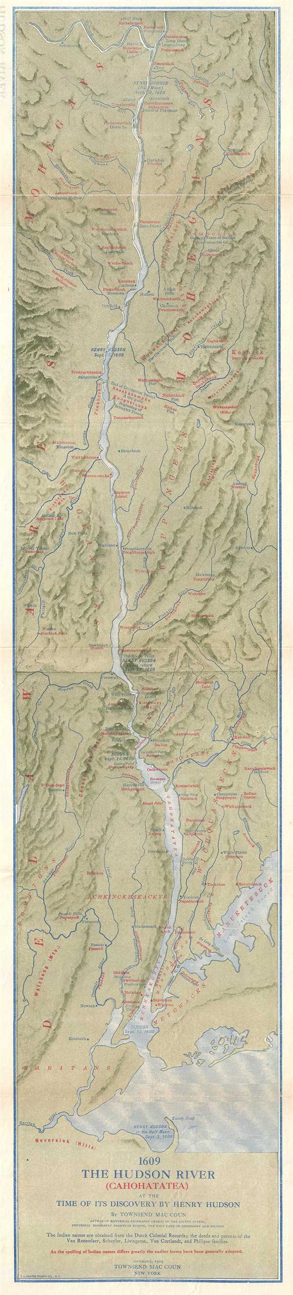
1609 The Hudson River (Cahohatatea) at the Time of its Discovery by Henry Hudson
1909 (dated) 32.25 x 7.25 in (81.915 x 18.415 cm) 1 : 380160
1909 (dated) 32.25 x 7.25 in (81.915 x 18.415 cm) 1 : 380160
Description
This is a 1909 Townsend MacCoun map of the Hudson River and its environs as they would have looked when Henry Hudson first ascended the river in 1609. Blending sites along the river from 1609 and 1909, the map depicts the region from Waterford, New York and the Mohawk River to Sandy Hook and New York Bay. Townsend traces Hudson's voyage up the river in his ship Halve Maen from his arrival at Sandy Hook on September 3 through his arrival in New York Harbor on September 12th to his arrival near present day Albany on September 19. Contemporary place names, such as Hackensack, Yonkers, Tarrytown, Poughkeepsie, and Albany are included in blue ink, while Indian names are provided in red ink, including Cahohatatea, the Indian name for the Hudson River. Creeks and regional topography are also illustrated.
This map was created by Townsend MacCoun and printed by the L.L. Poates Engineering Company in 1909.
This map was created by Townsend MacCoun and printed by the L.L. Poates Engineering Company in 1909.
Cartographer
Townsend MacCoun (1845 - September 10, 1932) was an American cartographer, publisher and historian active in the second half of the 19th and early 20th centuries. Townsend was born in Troy, New York, the son of John T. MacCoun and Angelica Rachel Douw (Lane) MacCoun. MacCoun attended Williams Collage, from which he was awarded degrees in 1866 and 1869. His composed several cultural and geographical works, including a history of the United States, another of the Holy Land, and a series of five historical maps of New York City. He also developed and proselytized employing a universal color coding system in all maps appearing in a single book or book series - a technique that remains in use today in many text books. He was a member of the Chi Psi Fraternity, the American Geographical Society, and the Paris Société Academique d'Histoire Internationale. More by this mapmaker...
Condition
Very good. Even overall toning. Verso repairs to fold separations. Blank on verso.