This item has been sold, but you can get on the Waitlist to be notified if another example becomes available, or purchase a digital scan.
1947 Sundberg Map of the German Reich
4thReich-sundberg-1947$175.00


Title
The 4th Reich?
1947 (dated) 14.25 x 20.5 in (36.195 x 52.07 cm)
1947 (dated) 14.25 x 20.5 in (36.195 x 52.07 cm)
Description
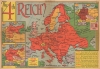
This is a March 1947 Edwin Sundberg map of Europe and German Empires published by the Sunday News. The map questions whether a fourth Germanic empire might one day arise from the ashes of the Third Reich.
A Closer Look
Using the title The 4th Reich?, Sundberg presents German history as a prediction for its future. Sundberg uses a shade of red reminiscent of blood to shade the German Reichs. Nazi Germany's conquests appear on the large central map and stretch from the French border with Spain deep into the U.S.S.R., south into Greece, and north to Scandinavia. Two insets to the left illustrate Germany's borders: in 1914, at the beginning of World War I (1914 - 1918), and in 1933, when Hitler and the Nazi Party rose to power. The 1914 borders represent the Second Reich (discussed below) built by Baron Otto von Bismarck. The 1933 borders illustrate Germany as Hitler found it before he led the Nazis on a rampage across Europe. The First Reich, better known as the Holy Roman Empire, is not illustrated. In the upper left, an inset highlights the four occupation zones in Germany following World War II (1939 - 1945). In March 1947, when this map was published, the Allies were still trying to find a way to govern occupied Germany jointly with the Soviets, even though that goal seemed out of reach.The German Reich
The term reich derives from the Germanic word that means 'realm' in English, but 'reich' generally means 'empire' in German. Deutsches Reich usually translates as 'German Empire' and refers to 3 previous empires. The first was the Holy Roman Empire (800/962 - 1806), and the second was from the unification of Germany in 1871 following the Franco-Prussian War until the end of World War I. After 1918, the German people continued to use the term even after the end of the German Empire and the abolition of the monarchy. Per Richard Evans…the continued use of the term 'German Empire', Deutsches Reich, by the Weimar Republic and all its institutions was far from being the least significant. The word 'Reich' conjured up an image among educated Germans that resonated far beyond the institutional structures Bismarck created: the successor to the Roman Empire; the vision of Gods' Empire here on earth; the universality of its claim to suzerainty; in a more prosaic sense, the concept of a German state that would include all German speakers in Central Europe - 'one People, one Reich, on Leader', as the Nazi slogan was to put it.The Nazi dictatorship used the phrase 'Third Reich' to refer to its regime. Its goal was to create a continuum between the Nazi regime and former German empires. Today, Nazi Germany is still commonly referred to as the Third Reich, but historians generally avoid the phrases 'First Reich' and 'Second Reich', which were commonly embraced by Nazi propaganda.
The Allied Occupation of Germany
The United States, Great Britain, and the Soviet Union agreed to divide conquered Germany into zones of occupation at the February 1945 Yalta Conference. The more comprehensive plan to create four separate zones was ratified at the subsequent Potsdam Conference. Unfortunately, the cordiality between the Western Allies and the Soviet Union began evaporating soon after the war, and by 1947, any effort to govern Germany jointly floundered. The British and American zones merged on January 1, 1947, creating the jointly administered 'Bizone'. This entity was soon joined by the French zone, necessitating a name change to 'Trizone'. In May 1949, these zones merged to form the Federal Republic of Germany (West Germany). In October 1949, the Soviets established the German Democratic Republic (East Germany). The occupation in West Germany continued until May 5, 1955, when the General Treaty transferred governance from the Allied military governments to civilian German leaders. East Germany remained under Soviet control until 1990.Publication History and Census
This map was drawn by Edwin Sundberg for the Sunday News and published on March 9, 1947. This is the only known cataloged example.Cartographer
Edwin L. Sundberg (1898 - 1978) was an American cartographer known for his pictorial pieces. Sundberg was a staff artist for the Sunday News in New York City and eventually became Chief Cartographer in charge of a small staff of artists. More by this mapmaker...
Source
Sunday News, March 9, 1947.
Condition
Very good. Newsprint. Wear along original fold lines. Closed edge tears professionally repaired on verso.
References
Evans, R.J., The Coming of the Third Reich (New York: Penguin Books) 2003, p.7.