Digital Image: 1945 Kulacz WWII Route Map of the 5th Tank Destroyer Group in Europe
5thTankDestGrp-kulacz-1945_d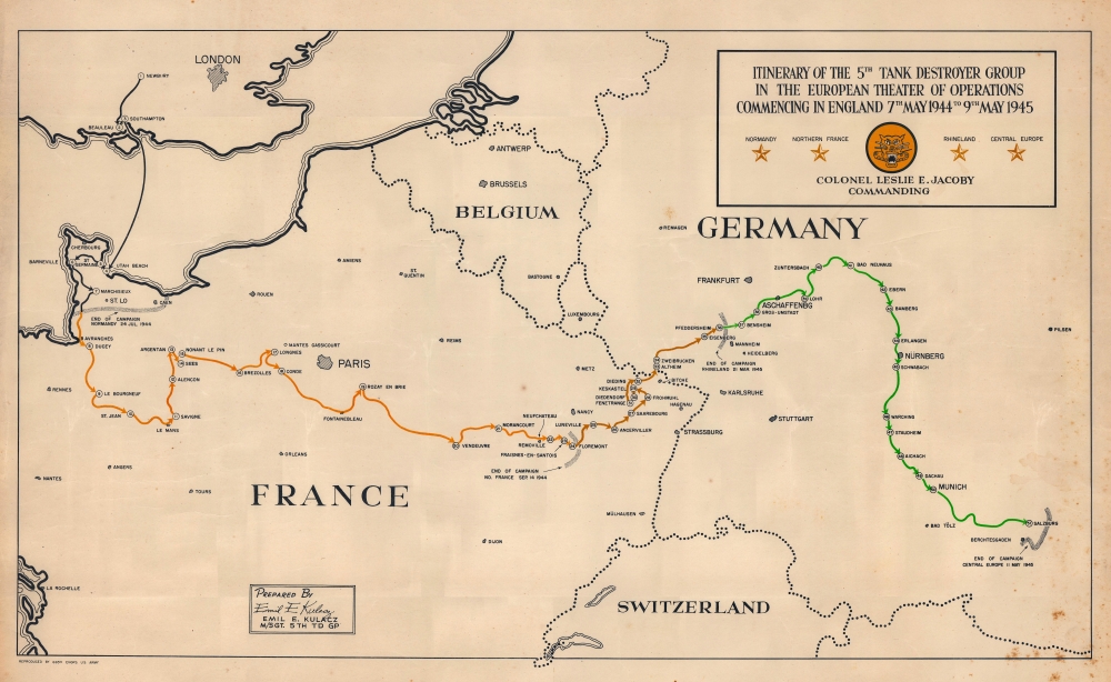

Title
Itinerary of the 5th Tank Destroyer Group in the European Theater of Operations Commencing in England 7th May 1944 to 9th May 1945.
1945 (undated) 16.25 x 27 in (41.275 x 68.58 cm)
1945 (undated) 16.25 x 27 in (41.275 x 68.58 cm)
Description
FOR THE ORIGINAL ANTIQUE MAP, WITH HISTORICAL ANALYSIS, CLICK HERE.
Digital Map Information
Geographicus maintains an archive of high-resolution rare map scans. We scan our maps at 300 DPI or higher, with newer images being 600 DPI, (either TIFF or JPEG, depending on when the scan was done) which is most cases in suitable for enlargement and printing.
Delivery
Once you purchase our digital scan service, you will receive a download link via email - usually within seconds. Digital orders are delivered as ZIP files, an industry standard file compression protocol that any computer should be able to unpack. Some of our files are very large, and can take some time to download. Most files are saved into your computer's 'Downloads' folder. All delivery is electronic. No physical product is shipped.
Credit and Scope of Use
You can use your digial image any way you want! Our digital images are unrestricted by copyright and can be used, modified, and published freely. The textual description that accompanies the original antique map is not included in the sale of digital images and remains protected by copyright. That said, we put significant care and effort into scanning and editing these maps, and we’d appreciate a credit when possible. Should you wish to credit us, please use the following credit line:
Courtesy of Geographicus Rare Antique Maps (http://www.geographicus.com).
How Large Can I Print?
In general, at 300 DPI, you should at least be able to double the size of the actual image, more so with our 600 DPI images. So, if the original was 10 x 12 inches, you can print at 20 x 24 inches, without quality loss. If your display requirements can accommodate some loss in image quality, you can make it even larger. That being said, no quality of scan will allow you to blow up at 10 x 12 inch map to wall size without significant quality loss. For more information, it is best consult a printer or reprographics specialist.
Refunds
If the high resolution image you ordered is unavailable, we will fully refund your purchase. Otherwise, digital images scans are a service, not a tangible product, and cannot be returned or refunded once the download link is used.
Cartographer
Emil E. Kulacz (October 26, 1920 - August 27, 1995) was an American commercial artist and World War II veteran. He was born in Chicopee, Massachusetts. Kulacz worked in the art department of the James McKinnon Company and The Springfield Union (the local newspaper) before enlisting in the U.S. Army on March 7, 1942. Eventually he reached the rank of Master Sergeant with the 5th Tank Destroyer Group. He served as a draftsman in the group headquarters, working on maps and operational charts. During his time in Europe, he was awarded the Bronze Star. Kulacz worked as the manager of Creative Services and Marketing at Stanley Home Inc. in Easthampton, Massachusetts, for 23 years, retiring in 1982. He was married to Valeria Wilk for 50 years, with whom he had 4 daughters. More by this mapmaker...