1972 Rigotti Map of the 72nd Troop Carrier Squadron over Europe during World War II
72ndTrpCarrierSqrdn-rigotti-1972$750.00


Title
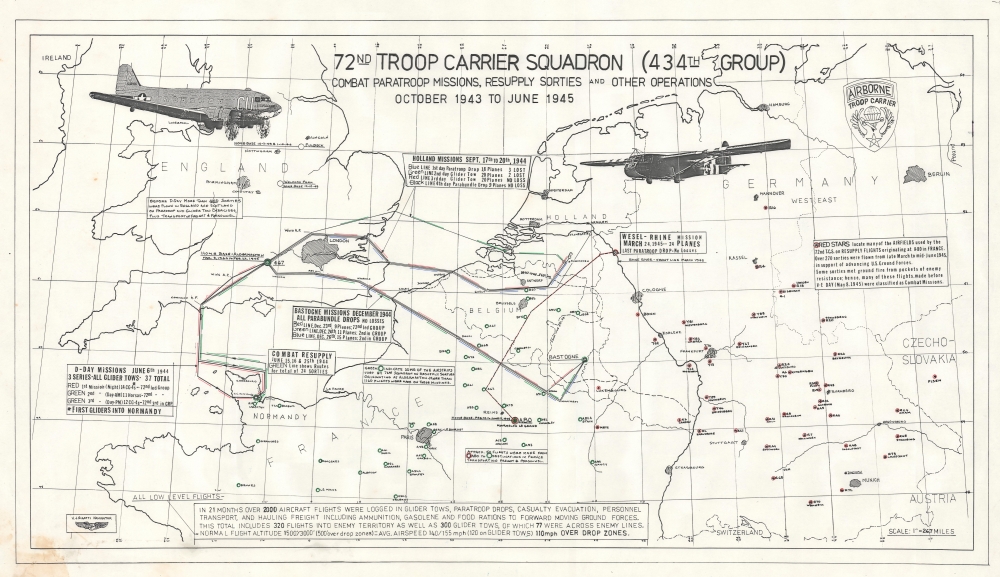
72nd Troop Carrier Squadron (434th Group) Combat Paratroop Missions, Resupply Sorties and Other Operations October 1943 to June 1945.
1972 (undated) 19.5 x 34.5 in (49.53 x 87.63 cm) 1 : 1691712
1972 (undated) 19.5 x 34.5 in (49.53 x 87.63 cm) 1 : 1691712
Description
This is a 1960 folding road map of Iran, prepared by Abbas Sahab, Iran's This is a c. 1972 Victor Rigotti map of the 72nd Troop Carrier Squadron over Europe during World War II. The map highlights the squadron's most important missions (including its three missions on D-Day) as well as the thousands of resupply and freight missions flown.
One curious feature of this map is the inclusion of Bahrain as part of Iran; this was the position of the Shah and the Iranian government at the time, based on the (generally quite indirect) rule of Bahrain by the Safavid and Zand Dynasties in the 17th and 18th centuries.
A Closer Look
Depicting from northern England to Switzerland and Austria, the map highlights the most important missions flown by the 72nd between October 1943 and June 1945. It also chronicles the squadron's time in Europe, marking bases they operated out of and places used for resupply sorties. The map begins in Fulbeck, northern England, where the 72nd was based from October 7, 1943, until January 10, 1944. During these months, the squadron flew sorties to practice airborne drops and towing gliders along with freight and personnel transportation. The squadron moved to Albermaston in March 1944 and stayed there until February 1945. The 72nd flew the June 6, 1944 D-Day missions to France from Albermaston, the missions to Holland during Market Garden, and the missions to Belgium to resupply Bastogne during the Battle of the Bulge. They moved to A80, an air base in eastern France not far from Reims, in February 1945 and remained there until they returned to the United States. Cities outlined in green indicate airstrips used during resupply sorties from Albermaston or A80. Cities circled in red received resupply flights from the 72nd as Allied ground forces advanced through Germany. Text boxes provide information about the missions and resupply flights.The 72nd Troop Carrier Squadron
The 72nd Troop Carrier Squadron was activated on February 9, 1943, at Alliance, Nebraska, as part of the 434th Troop Carrier Group, along with the 71st, 72nd, and 74th Squadrons. For the first few months of training, there were no available C-47s, so the group emphasized ground training until it received aircraft. Once the C-47s were available, flight training began, with an emphasis on formation flying and pick-up, tow, and release of gliders. The group arrived in England on October 7, 1943, and continued training until participating in the D-Day operations on June 6, 1944, as part of Operation OVERLORD. The group also took part in Operation MARKET GARDEN (the airborne drop into Holland) in September 1944 and Operation VARSITY (the airborne drop on the east side of the Rhine) in March 1945. When not participating in airborne operations, the 434th flew thousands of resupply missions. After the end of the war, the 434th continued to fly resupply missions and flew missions to evacuate freed prisoners of war. They returned to the United States beginning in mid-June and completed in mid-August.Publication History and Census
This map was drawn by Victor J. Rigotti and likely created between 1972 and 1990. Most maps published right after the end of the war include publication information, such as which topographic company printed the map. This map is not cataloged in any institutional collections. The only other examples we have seen have appeared in photographs accompanying newspaper articles about veterans of the 72nd Troop Carrier Squadron, the earliest of which dates from November 11, 1994 (Veteran's Day), eleven months after the death of Victor J. Rigotti, who we think created this piece. We have dated this map c. 1972 because that is the year of the first 72nd Troop Carrier Squadron reunion. The two newspaper articles were from Texas and Ohio, making it likely that this piece was distributed at one of these reunions.most prominent contemporary map publisher. It reflects the heavy investments in infrastructure undertaken by the Shah's government in the preceding years.A Closer Look
Iran is presented with red overprint indicating provinces and light blue overprint used to display waterways. True to the title, the main focus is on infrastructure, with roads of several grades, railways, and air routes denoted, along with projected routes of each. Distances by road between cities are written along roads. Cities and towns, oil pipelines, administrative boundaries, and archaeological ruins are also recorded. An inset relief map of Iran appears at left, reflecting the country's famous mountainous terrain, while a large table of distances between cities appears at bottom-left.One curious feature of this map is the inclusion of Bahrain as part of Iran; this was the position of the Shah and the Iranian government at the time, based on the (generally quite indirect) rule of Bahrain by the Safavid and Zand Dynasties in the 17th and 18th centuries.
Publication History and Census
This map was prepared by Abbas Sahab's Geographical and Drafting Institute in Iran. It is the second ('new') edition of the map, originally published in 1958. Later editions would continue to be published in the early 1980s. The present edition is listed among the holdings of ten institutions in the OCLC.Cartographer
Victor J. 'Vic' Rigotti (September 5, 1916 - January 22, 1994) was a World War II veteran. Rigotti was born in Rockford, Illinois. He enlisted in the U.S. Army Air Corps Reserve in August 1942 and was activated in February 1943. In October 1943, Rigotti graduated from the Pan American Airways Navigation Section of the University of Miami as a second lieutenant. He was promoted to first lieutenant in August 1944. During the war he was awarded the Air Medal and three Oak Leaf Clusters. He led a flight of C-47s back to the United States from Europe beginning in July 1945 and took the South Atlantic route through Africa and South America. He was discharged on December 19, 1945. More by this mapmaker...
Condition
Very good. Closed margin tears professionally repaired on verso. Some soiling in lower left corner.