This copy is copyright protected.
Copyright © 2025 Geographicus Rare Antique Maps
Digital Image: 1880 H. Windwart Map of the Lower East Side south of Grand, New York City
74-CorlearsHood-beers-1880_d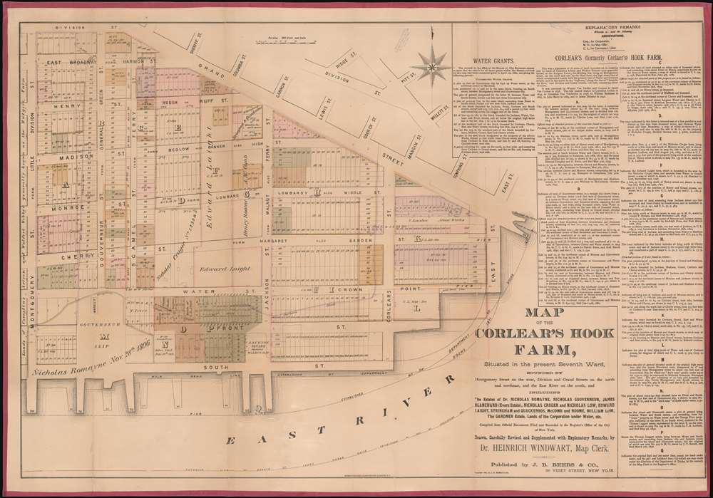

FOR THE ORIGINAL ANTIQUE MAP, WITH HISTORICAL ANALYSIS, CLICK HERE.
Digital Map Information
Geographicus maintains an archive of high-resolution rare map scans. We scan our maps at 300 DPI or higher, with newer images being 600 DPI, (either TIFF or JPEG, depending on when the scan was done) which is most cases in suitable for enlargement and printing.
Delivery
Once you purchase our digital scan service, you will receive a download link via email - usually within seconds. Digital orders are delivered as ZIP files, an industry standard file compression protocol that any computer should be able to unpack. Some of our files are very large, and can take some time to download. Most files are saved into your computer's 'Downloads' folder. All delivery is electronic. No physical product is shipped.
Credit and Scope of Use
You can use your digial image any way you want! Our digital images are unrestricted by copyright and can be used, modified, and published freely. The textual description that accompanies the original antique map is not included in the sale of digital images and remains protected by copyright. That said, we put significant care and effort into scanning and editing these maps, and we’d appreciate a credit when possible. Should you wish to credit us, please use the following credit line:
Courtesy of Geographicus Rare Antique Maps (http://www.geographicus.com).
How Large Can I Print?
In general, at 300 DPI, you should at least be able to double the size of the actual image, more so with our 600 DPI images. So, if the original was 10 x 12 inches, you can print at 20 x 24 inches, without quality loss. If your display requirements can accommodate some loss in image quality, you can make it even larger. That being said, no quality of scan will allow you to blow up at 10 x 12 inch map to wall size without significant quality loss. For more information, it is best consult a printer or reprographics specialist.
Refunds
If the high resolution image you ordered is unavailable, we will fully refund your purchase. Otherwise, digital images scans are a service, not a tangible product, and cannot be returned or refunded once the download link is used.
Heinrich Windwart (July 12, 1810 - April 30, 1881) was a German civil servant, revolutionary, medical doctor, and map publisher. He was born in Bavaria and studied at the University of Jena. He was heavily involved in the German Revolutions of 1848. When the revolutions were suppressed, he went into exile, first in Switzerland, then France, and ultimately, in 1853, to the United States. He initially settled in Baltimore, but moved to New York in the 1860s when his fellow German 'Forty-Eighter,' Franz Sigel (1824 - 1902), was elected Registrar of New York City, and offered him a clerk position. Windwart was one of several map publishers, the most famous of whom was John Bute Holmes, who was able to leverage cartographic skill to capitalize on the New York City transition from grand 18th century estates to the meticulously gridded and plotted structure of the Commissioner's Plan. More by this mapmaker...
James Botsford Beers (October 16, 1811 - June 3, 1901) was an American map publisher based in Connecticut in the second half of the 19th century. Beers was born in Newtown, Connecticut. He married Huldah Clarke (1813 - 1893) on August 30, 1835, in his hometown. They had five children in 18 years of marriage. He lived in Brooklyn, New York, from about 1845 where he dealt in jewelry and gold pens. Beers started publishing maps as 'J. B. Beers' in 1863, possibly inspired by the success of John Bute Holmes (1822 - 1887). In 1867, in partnership with A.D. Ellis and G.G. Soule, published his Atlas of New York and Vicinity. His son Frederick W. Beers joined the family business in 1870, at which point the firm was renamed 'J. B. Beers and Company'. Botsford Beers is the progenitor of the prolific Beers mapmaking family - who mostly published out of New York. He worked with his brother Charles Henry Beers (November 3, 1813 - March 5, 1892), son Frederick William Beers (August 17, 1839 - September 8, 1933), and grandsons Silas Norman Beers (September 3, 1837 - May 12, 1873) and Daniel Glover Beers (October 19, 1841 - February 12, 1913). Learn More...
Neuman and Dinglinger Lithography (fl. 1880 - 1882) was a New York City based lithography and engraving firm based at the Northwest corner of Pearl and Elm Streets, New York City. Little is known of their business. They published an important chronological chart of American history, as well as maps for James Botsford Beers (1811 - 1901) and John Bute Holmes (1822 - 1887). In addition to maps, they also produced stunning chromolithograph trade cards for the tobacco industry. Most of their work dates to the early 1880s. Learn More...
Copyright © 2025 Geographicus Rare Antique Maps | Geographicus Rare Antique Maps
This copy is copyright protected.
Copyright © 2025 Geographicus Rare Antique Maps