This copy is copyright protected.
Copyright © 2025 Geographicus Rare Antique Maps
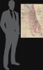
Digital Image: 1891 Turner and Bond City Plan or Map of Chicago, Illinois
ChicagoSuburbs-turnerbond-1891_d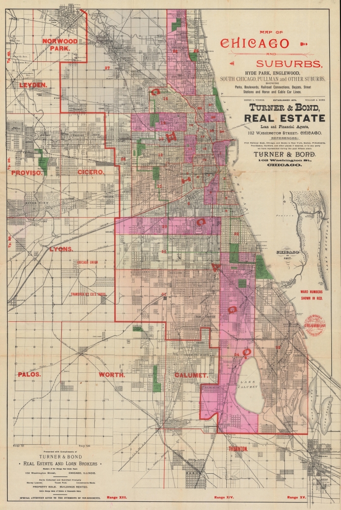


FOR THE ORIGINAL ANTIQUE MAP, WITH HISTORICAL ANALYSIS, CLICK HERE.
Digital Map Information
Geographicus maintains an archive of high-resolution rare map scans. We scan our maps at 300 DPI or higher, with newer images being 600 DPI, (either TIFF or JPEG, depending on when the scan was done) which is most cases in suitable for enlargement and printing.
Delivery
Once you purchase our digital scan service, you will receive a download link via email - usually within seconds. Digital orders are delivered as ZIP files, an industry standard file compression protocol that any computer should be able to unpack. Some of our files are very large, and can take some time to download. Most files are saved into your computer's 'Downloads' folder. All delivery is electronic. No physical product is shipped.
Credit and Scope of Use
You can use your digial image any way you want! Our digital images are unrestricted by copyright and can be used, modified, and published freely. The textual description that accompanies the original antique map is not included in the sale of digital images and remains protected by copyright. That said, we put significant care and effort into scanning and editing these maps, and we’d appreciate a credit when possible. Should you wish to credit us, please use the following credit line:
Courtesy of Geographicus Rare Antique Maps (http://www.geographicus.com).
How Large Can I Print?
In general, at 300 DPI, you should at least be able to double the size of the actual image, more so with our 600 DPI images. So, if the original was 10 x 12 inches, you can print at 20 x 24 inches, without quality loss. If your display requirements can accommodate some loss in image quality, you can make it even larger. That being said, no quality of scan will allow you to blow up at 10 x 12 inch map to wall size without significant quality loss. For more information, it is best consult a printer or reprographics specialist.
Refunds
If the high resolution image you ordered is unavailable, we will fully refund your purchase. Otherwise, digital images scans are a service, not a tangible product, and cannot be returned or refunded once the download link is used.
Henry L. Turner (August 26, 1845 - July 12, 1915) was an American businessman and military officer. Born in Oberlin, Ohio, before the age of 20 Turner had graduated from Oberlin College with honors and had served as an officer in two regiments during the American Civil War (1861 - 1865). First, he served as a lieutenant in the 150th Regiment, Ohio Volunteers, and then as Lieutenant and Adjutant for the 1st Regiment United States Colored troops. He fought in battles at Fort Stevens, the siege of Richmond, the second battle of Fair Oaks, the attack on Fort Fisher, and the capture of General Joseph E. Johnston's Army. After the war, he moved to Chicago, Illinois, where he worked with the 'Advance' newspaper. At some point after that he moved to Philadelphia and worked for Jay Cook and Company, the great banking house. He worked for that firm until it failed in 1873. At this point he returned to Chicago and began working for the 'Advocate' again. He bought the paper and managed it for two years before selling it. Turner moved into the world of real estate in 1874 when he founded the firm Turner and Marsh with his brother-in-law. Marsh (the brother-in-law) soon left the firm in favor of a job in Europe, and Turner began a partnership with William A. Bond, which lasted until 1892 when Turner retired from the business. Upon his retirement, Turner opened a banking investment business, which existed until at least 1900. In 1898, when the Spanish-American War was declared, Turner reentered the military as the commanding officer of the 1st Illinois National Guard, which was soon federalized. They were sent to Santiago, Cuba, and participated in the battle that captured that city. He had been in ill health since suffering from sunstroke during the Spanish-American War. More by this mapmaker...
William A. Bond (November 15, 1849 - June 10, 1943) was an American real estate businessman active in Chicago. Born in Newark, New Jersey, Bond moved to Chicago when he was 5 attended public schools in Chicago and then took some college courses. He began working for Hurlbut and Edsell (wholesale druggists), and by the age of 18 was the firm's head bookkeeper. He began working in the real estate business three years later, at the age of 21, in March 1871. The following year, Bond's real estate office burned during the Great Chicago Fire of 1871. Bond reestablished his office after this disaster and continued in the real estate business for the rest of his life. Bond spent 1874 traveling in Europe, where he married Sarah B. Fisher, also from Chicago. When Bond returned in 1875, he established the real estate firm Turner and Bond with Colonel Henry L. Turner. Turner and Bond existed for 17 years, when Bond bought out Turner's interest in the business in 1892. Afterward, the business was called William A. Bond and Company. Bond was a charter member of the Chicago Real Estate Board and was President of the board in 1893, the year of the World's Columbian Exposition. Learn More...
Copyright © 2025 Geographicus Rare Antique Maps | Geographicus Rare Antique Maps
This copy is copyright protected.
Copyright © 2025 Geographicus Rare Antique Maps