1887 Norie and Wilson Blueback Nautical Chart of Map of the English Channel
EnglishChannel-noriewilson-1887$800.00


Title
The English Channel.
1887 (dated) 41.25 x 83 in (104.775 x 210.82 cm) 1 : 338000
1887 (dated) 41.25 x 83 in (104.775 x 210.82 cm) 1 : 338000
Description
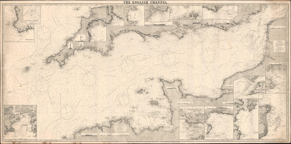
This is a rare 1887 Norie and Wilson blueback nautical chart of the English Channel. This massive chart is nearly 7 feet long and contains excellent coastal detail and beautiful insets of ports along the English and French coasts.
A Closer Look
Depicting from the Scilly Islands to the Pas de Calais, this chart provides mariners with a wealth of information concerning the English Channel. Compasses and possible courses are included, with cities, towns, and villages labeled along the navigable coasts. Red and yellow manuscript color mark lighthouses and circles illustrate the range at which many of these lights can be seen. The Isle of Wight, Jersey, and Guernsey are included, along with smaller coastal islands. Numerous insets fill England and France: Land's End, Penzance Bay, Dartmouth, Tor Bay, Exmouth, Alderney, Beachy Head, Portsmouth, Needles Channel, Falmouth, The Downs, Portland and Weymouth, Havre, Cherbourg, and Plymouth Sound. There are also smaller coastal profile views and illustrations of 3 lighthouses in Cornwall.Blueback Charts
Blueback nautical charts began appearing in London in the late 18th century. Bluebacks, as they came to be called, were privately published large-format nautical charts known for their distinctive blue paper backing. The backing, a commonly available blue manila paper traditionally used by publishers to wrap unbound pamphlets, was adopted as a practical way to reinforce the low-quality paper used by private chart publishers trying to cut costs. The earliest known blueback charts include a 1760 chart issued by Mount and Page and a 1787 chart issued by Robert Sayer. The tradition took off in the early 19th century, when British publishers like John Hamilton Moore, Robert Blachford, James Imray, William Heather, John William Norie, Charles Wilson, David Steel, R. H. Laurie, and John Hobbs, among others, rose to dominate the chart trade. Bluebacks became so popular that the convention was embraced by chartmakers outside of England, including Americans Edmund March Blunt and George Eldridge, as well as Scandinavian, French, German, Russian, and Spanish chartmakers. Blueback charts remained popular until the late 19th century when government-subsidized organizations like the British Admiralty Hydrographic Office and the United States Coast Survey began issuing their own superior charts on high-quality paper that did not require reinforcement.Publication History and Census
This chart was compiled and drawn by J.W. Appleton, engraved by Homewood and Son, and published by Norie and Wilson in 1887. This piece does not appear in OCLC and is the only known cataloged example.CartographerS
John William Norie (June 3, 1772 - December 24, 1843) was a British teacher of navigation, hydrographer, chart maker, and publisher of maritime manuals active in London, England in the late 18th and early 19th centuries. Norie was born in Wapping, London, an area long associated with the maritime sciences. Norie's career as a chart maker commenced under the tutelage of William Heather, a prominent purveyor and publisher of nautical charts, pilot books, and navigational tools who took over the firm of Mount and Page in 1765. Heather and Norie were likely acquainted through John Hamilton Moore, another important chart maker with whom both seem to have been associated early in their careers. Heather hired Norie to teach basic navigation at his shop at 157 Leadenhall Street. Under Heather Norie also distinguished himself as a draftsman, completing many of the early charts associated with the Heather firm. When Heather died in 1812 John Norie partnered with George Wilson, a moneyed 'man about town' with little experience in the maritime trades, to acquire the map and chart business at 9500 British Pounds. It proved a good deal for Norie, who retained all copyright privileges and drew 1/4 quarter share of business profits, as well an impressive quarterly salary and, for doing all of the work, 1/3rd of Wilson's share. The firm, referred to as the 'Naval Warehouse' quickly acquired a reputation for quality navigational materials and became a favorite of merchant seamen. It was even referenced in Charles Dickens' classic novel Dombey and Son. In 1819, Norie and Wilson acquired the failing chart business of David Steel, which significantly increased the size, though not quality, of their chart catalogue. With the rise of the British Admiralty and its own maritime chart productions, the business of "Chart Purveyor" in London dramatically changed. Admiralty charts and pilot books, designed for military use, were offered through established intermediaries, like Norie, at bargain prices. Most chart makers of the period found it profitable to use the highly technical Admiralty charts to update their own more decorative vernacular charts. For a brief time this practice proved exceptionally profitable but eventually began to draw criticism. Nonetheless, Norie retired to Edinburgh in 1840 and died a wealthy man in 1843. In 1840 the business passed to a nephew of George Wilson, Charles Wilson, who renamed the firm "Norie & Wilson". William Heather Norie, J. W. Norie's own son, produced few charts, instead pursuing a career in the legal field. Norie & Wilson merged with James Imray's prosperous chart business in 1899, becoming Imray, Laurie, Norie & Wilson, a profitable concern that remains active in the maritime charting industry. More by this mapmaker...
Charles Wilson (1807 - May 16, 1882) was a British-Indian publisher of nautical charts and maps based in London, England. Born in Lucknow, India, Wilson was the son Lieutenant-Colonel William Wilson and his wife Hoosainee Begum, an Indian princess, who was the daughter of the Nizam of Ashrafabad. Wilson was educated in England and worked in the wine trade before joining the Norie firm in 1838. Norie had already partnered with another Wilson, George, who was a nephew to Charles. When Norie retired in 1840, Charles Wilson took over the firm publishing as 'Charles Wilson (Late J.W. Noire and Wilson)'. He married Jane Arabella Bingle on July 1, 1846. Wilson died in 1882 passing the firm on to his sons, George and William Wilson. The brothers merged the firm with that of J. Imray and Sons in 1899 and, as Imray, Laurie, Norie and Wilson Ltd., they continue to publish to the present day. Learn More...
Thomas Homewood (September 21, 1806 - November 20, 1885) was a British map engraver. Born in London, Homewood apprenticed as an engraver in 1820. By 1841, Homewood appeared as an engraver in the census and a chart engraver in 1851. His son Henry Stephenson Homewood (September 19, 1839 - March 30, 1916) joined his father's firm as an engraver as early as 1861. Both Homewoods are noted as map and chart engravers and worked for J. W. Norie and Norie and Wilson. Thomas Homewood retired in 1881. Henry Homewood retired in 1900. Learn More...
Condition
Very good. Light soiling. Very small area of loss along top edge.