This copy is copyright protected.
Copyright © 2025 Geographicus Rare Antique Maps
Digital Image: 1781 Pouchot Map of New York and Canada: French and Indian War
FrenchIndianWar-pouchot-1781_d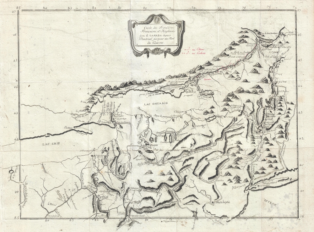

FOR THE ORIGINAL ANTIQUE MAP, WITH HISTORICAL ANALYSIS, CLICK HERE.
Digital Map Information
Geographicus maintains an archive of high-resolution rare map scans. We scan our maps at 300 DPI or higher, with newer images being 600 DPI, (either TIFF or JPEG, depending on when the scan was done) which is most cases in suitable for enlargement and printing.
Delivery
Once you purchase our digital scan service, you will receive a download link via email - usually within seconds. Digital orders are delivered as ZIP files, an industry standard file compression protocol that any computer should be able to unpack. Some of our files are very large, and can take some time to download. Most files are saved into your computer's 'Downloads' folder. All delivery is electronic. No physical product is shipped.
Credit and Scope of Use
You can use your digial image any way you want! Our digital images are unrestricted by copyright and can be used, modified, and published freely. The textual description that accompanies the original antique map is not included in the sale of digital images and remains protected by copyright. That said, we put significant care and effort into scanning and editing these maps, and we’d appreciate a credit when possible. Should you wish to credit us, please use the following credit line:
Courtesy of Geographicus Rare Antique Maps (http://www.geographicus.com).
How Large Can I Print?
In general, at 300 DPI, you should at least be able to double the size of the actual image, more so with our 600 DPI images. So, if the original was 10 x 12 inches, you can print at 20 x 24 inches, without quality loss. If your display requirements can accommodate some loss in image quality, you can make it even larger. That being said, no quality of scan will allow you to blow up at 10 x 12 inch map to wall size without significant quality loss. For more information, it is best consult a printer or reprographics specialist.
Refunds
If the high resolution image you ordered is unavailable, we will fully refund your purchase. Otherwise, digital images scans are a service, not a tangible product, and cannot be returned or refunded once the download link is used.
Pierre Pouchot de Maupas (April 8, 1712 – May 8, 1769) was a French historian, military engineer, and army officer in the French regular army active in Europe during the War of Austrian Succession and in America during French and Indian War. Pouchot was born in Grenoble, France, the son of a merchant. He joined the army at 21 as a volunteer engineer and was appointed second lieutenant in the Régiment de Béarn on May 1 of 1734. During the War of the Austrian Succession, his engineering service earned him a Cross of the Order of St. Louis and, in September 1748, a commission as Captain. Later, during the French and Indian War, he was assigned to the Canadian theater, serving at Fort Frontenac (Kingston, Ontario) and Fort Niagara (Youngstown, NY), where his engineering expertise helped to shore up the crumbling defenses. In July and August of 1756, his unit was assigned to lay out the siege works for the Battle of Fort Oswego (Chouaguen), in upstate New York. Afterwards, he moved between forts, including Frontenac, Ticonderoga, Montreal, Niagara, and Rouillé (Toronto), as needed. He developed strong relationships with France's American Indian allies especially the Cayuga, Onodaga, Delaware, Shawnee, Mississagua, and Seneca who called him Sategariouaen or Sategayogen, meaning 'the center of good transactions.' He was nonetheless captured by the British following Sir William Johnson's successful siege of Fort Niagara. Johnson treated him as a gentleman and, it is said, before Pouchot returned to Montreal from New York, he hosted a dinner party for the British officers. After the war he returned to France, where he compiled an important memoire of the French and Indian War, Mémoires sur la dernière guerre de l'Amérique septentrionale entre la France et l'Angleterre, considered the most accurate French perspective narrative of the war from an actual soldier. Later, he joined French forces occupying of Corsica. There, in 1769, while reconnoitering a post, he was killed. His memoire was published posthumously in 1781. More by this mapmaker...
Copyright © 2025 Geographicus Rare Antique Maps | Geographicus Rare Antique Maps
This copy is copyright protected.
Copyright © 2025 Geographicus Rare Antique Maps