This item has been sold, but you can get on the Waitlist to be notified if another example becomes available, or purchase a digital scan.
1949 Turner Pictorial Map of the Gaspé Peninsula (Gaspésie), Canada
Gaspesie-turner-1949$137.50

Title
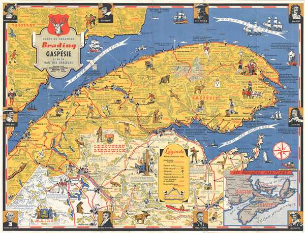
Carte de Vacances Brading de la Gaspésie et de la Baie des Chaleurs.
1949 (dated) 17 x 22.5 in (43.18 x 57.15 cm) 1 : 1584000
1949 (dated) 17 x 22.5 in (43.18 x 57.15 cm) 1 : 1584000
Description
This is a Stanley Turner pictorial map of the Gaspésie Peninsula in Canada. The map depicts from Saint Siméon in Québec to Saint Laurence Bay and the Baie des Chaleurs and from the Saguenay region of Québec to Maine. A presentation of both contemporary life in this part of Canada and historical notes is included. The historical notes reference the foundation of settlements in the region by European colonists, as well as several different conflicts, including the British invasion of Maine from New Scotland in 1814 and the fact that the masts for Nelson's flotilla came from New Brunswick. Numerous towns and villages are labeled, with churches, houses, and lighthouses depicted in profile. Roads, railroads, and airports are also illustrated. Vignettes are scattered throughout, depicting trains, native wildlife, and historical scenes. Ocean-going sailing ships appear in the Baie de Chaleurs and in the Saint Lawrence Gulf. Around the border, portraits of famous men who influenced the history of the region are included, such as Jacques Cartier, Louis Kirk, and Louis XIII. An inset map of the Maritime Provinces is included in the lower right corner, depicting New Brunswick, New Scotland, and Prince Edward Island.
This map was drawn by Stanley Turner and published by Brading's Capital Brewing Ltd. in 1949.
This map was drawn by Stanley Turner and published by Brading's Capital Brewing Ltd. in 1949.
Cartographer
Stanley Francis Turner (1883 – 1953) was a visual artist and painter based in Toronto, Canada. Turner was born in Aylesbury, England. He studied art in London at the South Kensington School before migrating to Canada in 1903, where he studied at Ontario College of Art under George Reid and J. W. Beatty. Turner is best known as a painter and designer capable of working in a variety of mediums. During World War II, Turner took a contract with the Globe and Mail to illustrate pictorial maps of war events. Turner may have maintained the rights to his war maps, as he also seems to have had a contract with the advertiser and publisher, C.C. Peterson, also of Toronto, to publish and distribute his maps in the United States. Turner's maps are information dense and designed to illustrate the events of the war in an easily digestible pictorial format. Turner experimented with different ways of working with the cartographic ranging from simple Mercator projections to more contemporary equal-area projections. In 1930, Turner was elected an Associate of the Royal Canadian Academy of Arts. He died in Toronto in 1953. More by this mapmaker...
Condition
Very good. Wear along original fold lines. Text in French. Text on verso. Closed margin fold separation professionally repaired on verso.
References
OCLC 49164995.