This copy is copyright protected.
Copyright © 2025 Geographicus Rare Antique Maps
Digital Image: 1953 Henry Gross City Plan or Map of St. Louis, Missouri
GreaterStLouis-henrygross-1953_d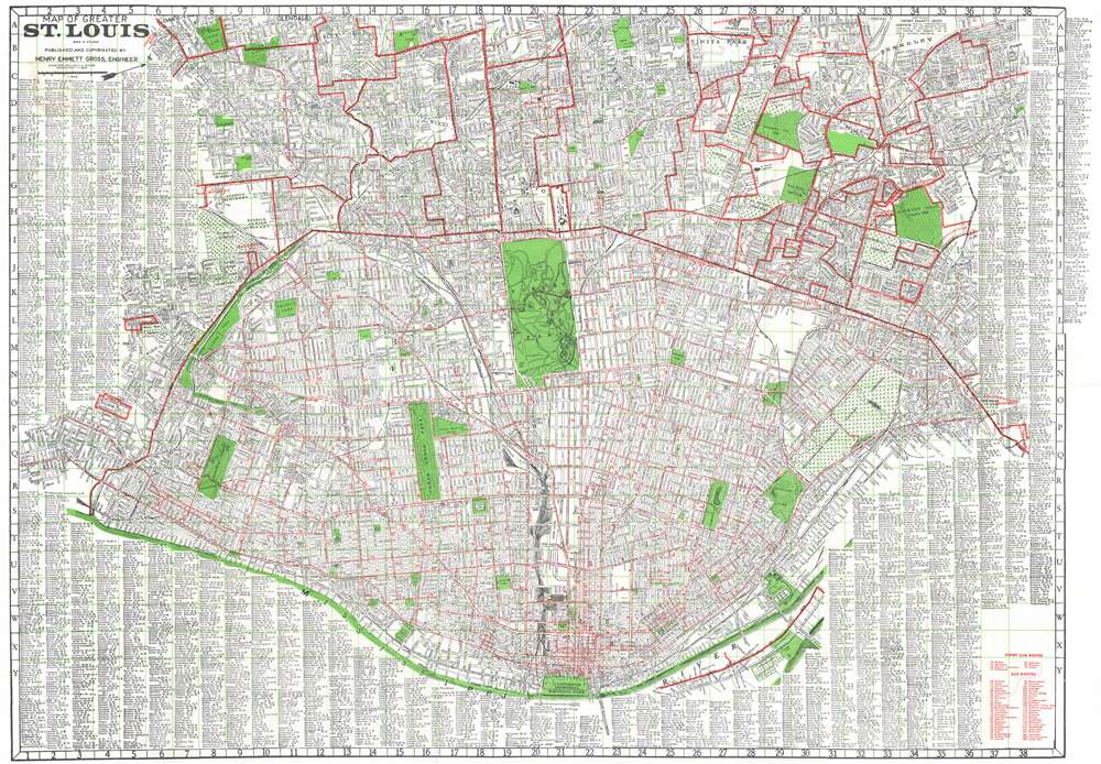

FOR THE ORIGINAL ANTIQUE MAP, WITH HISTORICAL ANALYSIS, CLICK HERE.
Digital Map Information
Geographicus maintains an archive of high-resolution rare map scans. We scan our maps at 300 DPI or higher, with newer images being 600 DPI, (either TIFF or JPEG, depending on when the scan was done) which is most cases in suitable for enlargement and printing.
Delivery
Once you purchase our digital scan service, you will receive a download link via email - usually within seconds. Digital orders are delivered as ZIP files, an industry standard file compression protocol that any computer should be able to unpack. Some of our files are very large, and can take some time to download. Most files are saved into your computer's 'Downloads' folder. All delivery is electronic. No physical product is shipped.
Credit and Scope of Use
You can use your digial image any way you want! Our digital images are unrestricted by copyright and can be used, modified, and published freely. The textual description that accompanies the original antique map is not included in the sale of digital images and remains protected by copyright. That said, we put significant care and effort into scanning and editing these maps, and we’d appreciate a credit when possible. Should you wish to credit us, please use the following credit line:
Courtesy of Geographicus Rare Antique Maps (http://www.geographicus.com).
How Large Can I Print?
In general, at 300 DPI, you should at least be able to double the size of the actual image, more so with our 600 DPI images. So, if the original was 10 x 12 inches, you can print at 20 x 24 inches, without quality loss. If your display requirements can accommodate some loss in image quality, you can make it even larger. That being said, no quality of scan will allow you to blow up at 10 x 12 inch map to wall size without significant quality loss. For more information, it is best consult a printer or reprographics specialist.
Refunds
If the high resolution image you ordered is unavailable, we will fully refund your purchase. Otherwise, digital images scans are a service, not a tangible product, and cannot be returned or refunded once the download link is used.
Henry Emmett Gross (August 8, 1906 - April 3, 1982) was an American engineer and map publisher. Born in Glendale, Missouri, in 1928 Gross received a bachelor's degree in engineering from the Missouri School of Mines and then went on to receive a master's degree in engineering from the University of Illinois. From 1936 until 1938, Gross taught petroleum engineering at the University of Oklahoma and then taught the same subject at Texas A and M from 1938 until 1942. During World War II, Gross lived in Chicago and directed the district engineering office of the federal government's Petroleum Administration for War. In 1945, Gross became the chief production engineer of the Kingwood Oil Company in Effingham, Illinois. However, he left a year later to take over the Gross Map Company in St. Louis. He owned and operated the Gross Map Company (which published maps of the St. Louis area) from 1946 until 1973 when he retired. The map company closed upon his retirement. Gross patented several inventions during his life, including a marine foundation for deep-water oil drilling and deep-sea salvage equipment for raising sunken ships, for which he became an honorary member of the Explorers Club. He married his wife, the former Margrete Brauer, in 1941 in Norman, Oklahoma. More by this mapmaker...
Copyright © 2025 Geographicus Rare Antique Maps | Geographicus Rare Antique Maps
This copy is copyright protected.
Copyright © 2025 Geographicus Rare Antique Maps