This copy is copyright protected.
Copyright © 2025 Geographicus Rare Antique Maps
Digital Image: 1962 Jimenez Pictorial Map of the Cuban Revolution
GuerraLiberacionCuba-jimenez-1962_d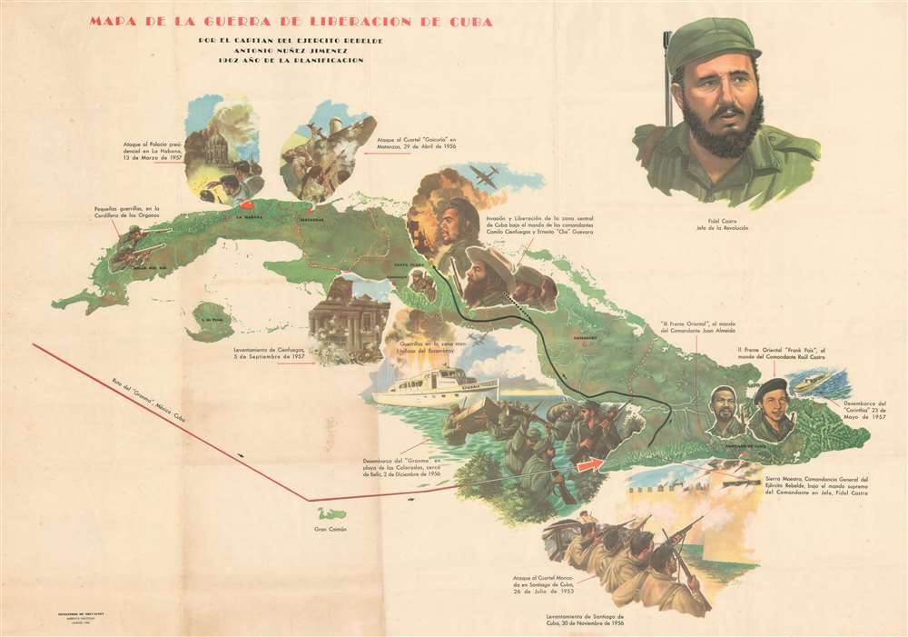

FOR THE ORIGINAL ANTIQUE MAP, WITH HISTORICAL ANALYSIS, CLICK HERE.
Digital Map Information
Geographicus maintains an archive of high-resolution rare map scans. We scan our maps at 300 DPI or higher, with newer images being 600 DPI, (either TIFF or JPEG, depending on when the scan was done) which is most cases in suitable for enlargement and printing.
Delivery
Once you purchase our digital scan service, you will receive a download link via email - usually within seconds. Digital orders are delivered as ZIP files, an industry standard file compression protocol that any computer should be able to unpack. Some of our files are very large, and can take some time to download. Most files are saved into your computer's 'Downloads' folder. All delivery is electronic. No physical product is shipped.
Credit and Scope of Use
You can use your digial image any way you want! Our digital images are unrestricted by copyright and can be used, modified, and published freely. The textual description that accompanies the original antique map is not included in the sale of digital images and remains protected by copyright. That said, we put significant care and effort into scanning and editing these maps, and we’d appreciate a credit when possible. Should you wish to credit us, please use the following credit line:
Courtesy of Geographicus Rare Antique Maps (http://www.geographicus.com).
How Large Can I Print?
In general, at 300 DPI, you should at least be able to double the size of the actual image, more so with our 600 DPI images. So, if the original was 10 x 12 inches, you can print at 20 x 24 inches, without quality loss. If your display requirements can accommodate some loss in image quality, you can make it even larger. That being said, no quality of scan will allow you to blow up at 10 x 12 inch map to wall size without significant quality loss. For more information, it is best consult a printer or reprographics specialist.
Refunds
If the high resolution image you ordered is unavailable, we will fully refund your purchase. Otherwise, digital images scans are a service, not a tangible product, and cannot be returned or refunded once the download link is used.
Antonio Núñez Jiménez (April 20, 1923 - September 13, 1998) was a Cuban scientist, politician, and revolutionary. Born in Alquízar, Jiménez founded the Caving Society of Cuba in 1940 at the age of 17. He graduated from the University of Havana as a Doctor of Philosophy and Letters in 1951 and served as a Captain of the Rebel Army under Commander Ernesto 'Che' Guevara during the Cuban Revolution. He held several positions in the Revolutionary Government of Cuba, including Director of the National Institute of Agrarian Reform (1959 - 1962), Head of Artillery (1960 - 1962), President-Founder of the Academy of Sciences of Cuba (1962 - 1972), Cuban Ambassador to Peru (1972 - 1978), Vice Minister of Culture (1978 - 1989), Deputy of the National Assembly (1976 - 1993). He also held the position of President of the National Monuments Commission, the Caving Society of Cuba, the Cuban Geographical Society, the Nature Foundation and the Man, and the Center for the Study of Rock Art of Latin America and the Caribbean at the time of his death in 1998. He graduated f rom Lomonosov University in Moscow in 1960 with a Ph.D. in Geographical Sciences. During his lifetime, Jiménez embarked on expeditions to the North Pole (1972), Antarctica (1998), Africa, China, Easter Island, and the Galápagos Islands, among many other locations. He also organized and participated in an expedition to the Amazon in 1987 and 1988 that followed the Napo, Amazonas, Megro, and Orinoco Rivers to the Caribbean and then continued through the Antilles Sea. He was also a prolific writer, publishing over 190 books and 1665 articles over the course of his professional life. More by this mapmaker...
Copyright © 2025 Geographicus Rare Antique Maps | Geographicus Rare Antique Maps
This copy is copyright protected.
Copyright © 2025 Geographicus Rare Antique Maps