This copy is copyright protected.
Copyright © 2025 Geographicus Rare Antique Maps
Digital Image: 1892 Roux Chromolithograph Map of Missions in Malabar, India
Malabar-staugustin-1892-2_d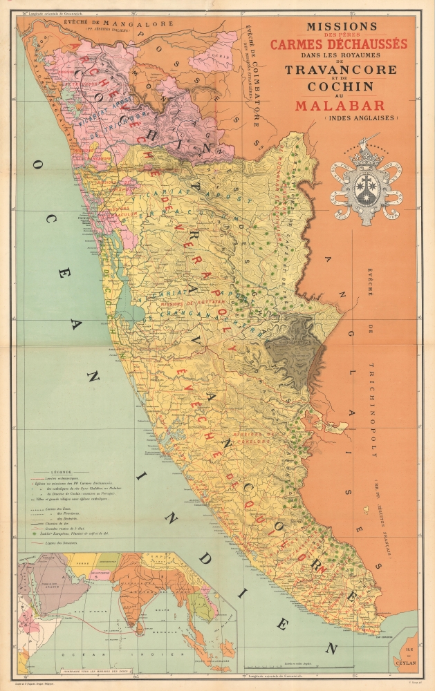


FOR THE ORIGINAL ANTIQUE MAP, WITH HISTORICAL ANALYSIS, CLICK HERE.
Digital Map Information
Geographicus maintains an archive of high-resolution rare map scans. We scan our maps at 300 DPI or higher, with newer images being 600 DPI, (either TIFF or JPEG, depending on when the scan was done) which is most cases in suitable for enlargement and printing.
Delivery
Once you purchase our digital scan service, you will receive a download link via email - usually within seconds. Digital orders are delivered as ZIP files, an industry standard file compression protocol that any computer should be able to unpack. Some of our files are very large, and can take some time to download. Most files are saved into your computer's 'Downloads' folder. All delivery is electronic. No physical product is shipped.
Credit and Scope of Use
You can use your digial image any way you want! Our digital images are unrestricted by copyright and can be used, modified, and published freely. The textual description that accompanies the original antique map is not included in the sale of digital images and remains protected by copyright. That said, we put significant care and effort into scanning and editing these maps, and we’d appreciate a credit when possible. Should you wish to credit us, please use the following credit line:
Courtesy of Geographicus Rare Antique Maps (http://www.geographicus.com).
How Large Can I Print?
In general, at 300 DPI, you should at least be able to double the size of the actual image, more so with our 600 DPI images. So, if the original was 10 x 12 inches, you can print at 20 x 24 inches, without quality loss. If your display requirements can accommodate some loss in image quality, you can make it even larger. That being said, no quality of scan will allow you to blow up at 10 x 12 inch map to wall size without significant quality loss. For more information, it is best consult a printer or reprographics specialist.
Refunds
If the high resolution image you ordered is unavailable, we will fully refund your purchase. Otherwise, digital images scans are a service, not a tangible product, and cannot be returned or refunded once the download link is used.
Pierre / Pieter Raoux (September 8, 1845 - October 3, 1917) was a Belgian graphic artist, engraver, printer, and lithographer active in Bruges from roughly 1879 to 1889. Raoux ws the eldest son of Francisca Lagast - at the time unmarried. When she married the carpenter Edmond Raoux in 1850, Pieter was legitimized. His family was nonetheless mired in poverty and Pieter was consigned to the care of the Broeders van Liefde (Brothers of Charity) at Katelijnestraat. Raoux studied art at the Brugse Academie and was later trained as a lithographer under Jacques Petyt (1822 - 1871). Roaux took over management of the Petyt studio, along with his widow, and ran it until 1874. Around this time he received a state grant to study the new printing technique of chromolithography in Paris. He received a subsequent private grant from Jean-Baptiste Bethune and printer-publisher Henri Desclée to study painting in Italy. Their intention was for him to take over the Saint Augustin printing house in Bruges. Although this project ultimately led to fruition, Raoux had a disagreement with Bethune and Desclée and started his own business in 1879. In 1889, he closed his printing studio and took over management of St. Augustin, as was intended. In this position most of his work was done on behalf of ecclesiastical orders, but included religious cards, memorials, blessings, and at least one map. His offices were at Noordzandstraat 85. More by this mapmaker...
Copyright © 2025 Geographicus Rare Antique Maps | Geographicus Rare Antique Maps
This copy is copyright protected.
Copyright © 2025 Geographicus Rare Antique Maps