Title
Mexico and Guatimala.
1835 (undated)
17 x 21 in (43.18 x 53.34 cm)
1 : 9216000
Description
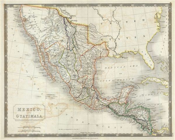
This is a beautiful map of Mexico and Guatemala from Sidney Hall's extremely scarce 1835 New General Atlas. It covers from Upper California and New Albion south to Guatemala, including the modern day regions of California, New Mexico, Arizona, Colorado, Utah, Nevada, Texas, Guatemala, Honduras, Nicaragua, El Salvador and Mexico. Hall's map offers an interesting pre-Republic mapping of Texas folded into the Intendancy of San Louis Potosi.
Further west this map really gets interesting with the mappings of Escalante and Humboldt very much in evidence. Hall curiously charts two lakes in the Great Basin, one labeled Timpanagos and another smaller lake further south labeled Teguayo or 'Salt Water.' The Great Salt Lake is said to have first been seen by Europeans in 1824, only a few years before this map was first published in 1827, so it is unlikely that Hall drew from this exploration. Instead, Hall is following Escalante's discoveries as recorded on the Miera map. The Escalante expedition actually visited Utah Lake (identified here as Teguayo), but only heard about the Great Salt Lake from local Native American Ute tribe. Miera, Escalante's cartographer, thus mapped Timpanagos as much larger than the unseen 'Great Salt Lake.'
Hall also maps the apocryphal Buenaventura River running from the Rocky Mountains westward through 'Salt Lake' and westward to San Francisco Bay. The Buenaventura is the last incarnation of the apocryphal River of the West, a long sought after speculative alternative to the Northwest Passage. The mapping of Buenaventura here again references legitimate discoveries by Escalante of the White River and the Sevier River. In this case, both are mistakenly associated with the River of the West and given an erroneous outlet into San Francisco Bay.
Towns, rivers, mountains, railroads, canals, marshes, forests, and various other important topographical details are noted. Elevation throughout is rendered by hachure and political and territorial boundaries are outlined in color. In addition to geographical notations, Hall also identifies a number of American Indian nations including the Moqui, Apache, Juma, Nochi, Poagos and Yahipias (with long beards). Several mines are also noted throughout.
Sidney Hall's New General Atlas was published from 1830 to 1857, the first edition being the most common, with all subsequent editions appearing only rarely. Most of the maps included in the first edition of this atlas were drawn between 1827 and 1828 and are most likely steel plate engravings, making it among the first cartographic work to employ this technique. Each of the maps in this large and impressive atlas feature elegant engraving and an elaborate keyboard style border. Though this is hardly the first map to employ this type of border, it is possibly the earliest to use it on such a large scale. Both the choice to use steel plate engraving and the addition of the attractive keyboard boarder are evolutions of anti-forgery efforts. Copper plates, which were commonly used for printing bank notes in the early 19th century, proved largely unsuitable due to their overall fragility and the ease with which they could be duplicated. In 1819 the Bank of England introduced a £20,000 prize for anyone who could devise a means to print unforgeable notes. The American inventors Jacob Perkins and Asa Spencer responded to the call. Perkins discovered a process for economically softening and engraving steel plates while Spencer invented an engraving lathe capable of producing complex patters repetitively - such as this keyboard border. Though Perkins and Spenser did not win the prize, their steel plate engraving technique was quickly adopted by map publishers in England, who immediately recognized its value. Among early steel plate cartographic productions, this atlas, published in 1830 by Longman Rees, Orme, Brown & Green stands out as perhaps the finest. This map was issued by Sidney Hall and published by Longman Rees, Orme, Brown & Green of Paternoster Row, London, in the 1835 edition of the Sidney Hall New General Atlas.
Cartographer
Sidney Hall (1788 - 1831) was an English engraver and map publisher active in London during the late 18th and early 19th centuries. His earliest imprints, dating to about 1814, suggest a partnership with Michael Thomson, another prominent English map engraver. Hall engraved for most of the prominent London map publishers of his day, including Aaron Arrowsmith, William Faden, William Harwood, and John Thomson, among others. Hall is credited as being one of the earliest adopters of steel plate engraving, a technique that allowed for finer detail and larger print runs due to the exceptional hardness of the medium. Upon his early death - he was only in his 40s - Hall's business was inherited by his wife, Selina Hall, who continued to publish under the imprint, "S. Hall", presumably for continuity. The business eventually passed to Sidney and Selina's nephew Edward Weller, who became extremely prominent in his own right. More by this mapmaker...
Source
Hall, S., A New General Atlas, with the Divisions and Boundaries, 1835.
Condition
Very good. Original platemark visible. Minor wear and verso repair near original centerfold. Some offsetting.
References
Rumsey 4224.047 (1830 edition). Philips (Atlases) 758.