This copy is copyright protected.
Copyright © 2025 Geographicus Rare Antique Maps
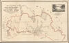
Digital Image: 1884 Glazier Map 'Rediscovering' the Source of the Mississippi, Minnesota
MississippiSource-glazier-1884_d


FOR THE ORIGINAL ANTIQUE MAP, WITH HISTORICAL ANALYSIS, CLICK HERE.
Digital Map Information
Geographicus maintains an archive of high-resolution rare map scans. We scan our maps at 300 DPI or higher, with newer images being 600 DPI, (either TIFF or JPEG, depending on when the scan was done) which is most cases in suitable for enlargement and printing.
Delivery
Once you purchase our digital scan service, you will receive a download link via email - usually within seconds. Digital orders are delivered as ZIP files, an industry standard file compression protocol that any computer should be able to unpack. Some of our files are very large, and can take some time to download. Most files are saved into your computer's 'Downloads' folder. All delivery is electronic. No physical product is shipped.
Credit and Scope of Use
You can use your digial image any way you want! Our digital images are unrestricted by copyright and can be used, modified, and published freely. The textual description that accompanies the original antique map is not included in the sale of digital images and remains protected by copyright. That said, we put significant care and effort into scanning and editing these maps, and we’d appreciate a credit when possible. Should you wish to credit us, please use the following credit line:
Courtesy of Geographicus Rare Antique Maps (http://www.geographicus.com).
How Large Can I Print?
In general, at 300 DPI, you should at least be able to double the size of the actual image, more so with our 600 DPI images. So, if the original was 10 x 12 inches, you can print at 20 x 24 inches, without quality loss. If your display requirements can accommodate some loss in image quality, you can make it even larger. That being said, no quality of scan will allow you to blow up at 10 x 12 inch map to wall size without significant quality loss. For more information, it is best consult a printer or reprographics specialist.
Refunds
If the high resolution image you ordered is unavailable, we will fully refund your purchase. Otherwise, digital images scans are a service, not a tangible product, and cannot be returned or refunded once the download link is used.
Willard Worchester Glazier (August 22, 1841 - April 26, 1905) was an American army officer, adventurer, lecturer, self-promoter, and conman active in the second half of the 19th century. Glazier was born in Fowler, New York. He attended Gouverneur Wesleyan Seminary and worked as a trapper in his spare time, saving enough to attend the State Normal School in Albany. During the American Civil War (1861 - 1865), Glazier served the Union cause in the Harris Light Cavalry, 2nd New York Cavalry. He was captured in 1863 and held in the notoriously harsh Libby Prison before escaping with about 100 others in 1864, only to be immediately recaptured and sent to the even more notorious Andersonville Prison. He escaped Andersonville in 1865 and returned to Albany to join the 26th New York Cavalry as a First Lieutenant. Glazier wasted no time in capitalizing on his wartime adventures in two self-authored books: Capture, Prison-Pen and Escape (1865) and Three Years in the Federal Cavalry (1870). These books were immensely successful, the first selling nearly 400,000 copies. He leveraged their success to launch a lecturing career in the Midwest. Despite his accomplishments, Glazier was reviled by most who knew him. He developed a practice of traveling with comely young women, who loudly promoted his lectures using their considerable charms. In one of many instances of public outrage, in 1879, an angry mother accused him of impregnating and abandoning her 15-year-old daughter. (The young woman herself refused to press charges.) Many of his lectures were promoted as fundraisers for the Grand Army of the Republic Relief Fund and other local charities, but none record receiving donations. He also claimed to be friends with George Armstrong Custer (1839 - 1876). The connection is dubious, but Custer, having died, could hardly refute them. The lectures themselves were poorly reviewed, the enticement of Glazier's young women being more of a draw than the man himself. The editor of the Iowa City Daily Press wrote,
Now Captain Glazier may be a good lecturer, and it may be that some deadbeat is travelling under his name … yet all who heard him are under the impression that he is a monumental fraud, only one degree less of an idiot than Sergeant Bates [another touring lecturer] … and relies on the efforts of the two ladies who preceded him, and bore the general public with pitiful wails to buy tickets. (October 9, 1876)He also staged self-promotional stunts. In one instance, he suddenly went missing and claimed to have been captured by Indians with three others who were burnt alive (so he claimed) while he made a heroic escape, outrunning his pursuers. Glazier's miraculous reappearance was reported by the Cleveland Leader under the heading Pained to Announce. His biggest scam was an 1881 expedition to clear doubt regarding Henry Schoolcrafts's 1832 identification of Lake Itasca as the source of the Mississippi River. When the planned expedition was announced, the St. Paul Daily Globe entreated American Indians in the region,
We have only to say to the untutored savages of the West, whose crimes are manifold … that you have now an opportunity to redeem yourselves. Prepare your shot-guns, and wait the coming of a careworn literary man in a canoe … Men of the Mississippi, do your duty. (June 26, 1881)Following the voyage, he contracted Rand McNally to publish a large map illustrating his discovery of Elk Lake (long known), which he identified as the source of the Mississippi, then renamed and significantly enlarged as 'Lake Glazier.' The geographic establishment aggressively rebuked Glazier's claims. Despite being technically correct, investigating Glazier, the Minnesota Historical Society dubbed him a 'quack explorer and charlatan adventurer.' Glazier was nonetheless undaunted, promoting his claims with two books, Down the Great River; Embracing an Account of the Discovery of the True Source of the Mississippi (1887) and Headwaters of the Mississippi comprising biographical sketches of early and recent explorers of the great river, and a full account of the discovery and location of its true source in a lake beyond Itasca (1894). He died of heart disease in Albany. More by this mapmaker...
Rand, McNally and Co. (fl. 1856 - present) is an American publisher of maps, atlases and globes. The company was founded in 1856 when William H. Rand, a native of Quincy, Massachusetts, opened a print shop in Chicago. Rand hired the recent Irish immigrant Andrew McNally to assist in the shop giving him a wage of 9 USD per week. The duo landed several important contracts, including the Tribune's (later renamed the Chicago Tribune) printing operation. In 1872, Rand McNally produced its first map, a railroad guide, using a new cost effective printing technique known as wax process engraving. As Chicago developed as a railway hub, the Rand firm, now incorporated as Rand McNally, began producing a wide array of railroad maps and guides. Over time, the firm expanded into atlases, globes, educational material, and general literature. By embracing the wax engraving process, Rand McNally was able to dominate the map and atlas market, pushing more traditional American lithographic publishers like Colton, Johnson, and Mitchell out of business. Eventually Rand McNally opened an annex office in New York City headed by Caleb S. Hammond, whose name is today synonymous with maps and atlases, and who later started his own map company, C. S. Hammond & Co. Both firms remain in business. Learn More...
Copyright © 2025 Geographicus Rare Antique Maps | Geographicus Rare Antique Maps
This copy is copyright protected.
Copyright © 2025 Geographicus Rare Antique Maps