This copy is copyright protected.
Copyright © 2025 Geographicus Rare Antique Maps
Digital Image: 1857 Thomas Devine Map of Northwestern Canada - a landmark map!
NorthwestCanada-cauchon-1857_d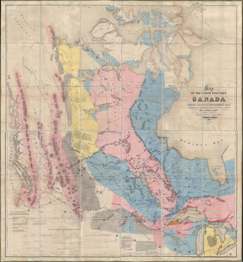


FOR THE ORIGINAL ANTIQUE MAP, WITH HISTORICAL ANALYSIS, CLICK HERE.
Digital Map Information
Geographicus maintains an archive of high-resolution rare map scans. We scan our maps at 300 DPI or higher, with newer images being 600 DPI, (either TIFF or JPEG, depending on when the scan was done) which is most cases in suitable for enlargement and printing.
Delivery
Once you purchase our digital scan service, you will receive a download link via email - usually within seconds. Digital orders are delivered as ZIP files, an industry standard file compression protocol that any computer should be able to unpack. Some of our files are very large, and can take some time to download. Most files are saved into your computer's 'Downloads' folder. All delivery is electronic. No physical product is shipped.
Credit and Scope of Use
You can use your digial image any way you want! Our digital images are unrestricted by copyright and can be used, modified, and published freely. The textual description that accompanies the original antique map is not included in the sale of digital images and remains protected by copyright. That said, we put significant care and effort into scanning and editing these maps, and we’d appreciate a credit when possible. Should you wish to credit us, please use the following credit line:
Courtesy of Geographicus Rare Antique Maps (http://www.geographicus.com).
How Large Can I Print?
In general, at 300 DPI, you should at least be able to double the size of the actual image, more so with our 600 DPI images. So, if the original was 10 x 12 inches, you can print at 20 x 24 inches, without quality loss. If your display requirements can accommodate some loss in image quality, you can make it even larger. That being said, no quality of scan will allow you to blow up at 10 x 12 inch map to wall size without significant quality loss. For more information, it is best consult a printer or reprographics specialist.
Refunds
If the high resolution image you ordered is unavailable, we will fully refund your purchase. Otherwise, digital images scans are a service, not a tangible product, and cannot be returned or refunded once the download link is used.
Thomas Devine (1818 - November 14, 1888) was an Irish surveyor and cartographer active in Canada during the middle part of the 19th century. Devine mastered surveying working for the Ordnance Survey of Ireland and the Royal Engineers. He immigrated to Canada around 1846 and took work as a provincial land surveyor, eventually becoming official surveyor and draftsman for the Crown Lands Department, Upper Canada. In 1857, he was put in charge of the Upper Canada Surveys Branch, succeeding Andrew Russell, and was immediately assigned the work of compiling and publishing a group of important maps focusing on western Canada. There he completed his most important work, a great wall map entitled Map of the North West part of Canada, considered the first map of the west compiled and published in Canada. Following the Confederation, he became the Deputy Surveyor of Ontario, producing his last map in 1877. He retired in 1879, returning briefly to Ireland before settling down in Montreal. He was a member of the Royal Geographical Society, the Geographical Society of Berlin, and the American Geographical and Statistical Society. More by this mapmaker...
Joseph-Édouard Cauchon (December 31, 1816 – February 23, 1885) was a Canadian journalist, businessman, and politician. Cauchon born in Quebec City, the scion of one of Canada's oldest and most distinguished French families. He was educated at the Petit Séminaire de Québec from 1830 until 1839, after which he studied law in the offices of James George Baird. He passed the Canadian Bar, but there no record that he ever practiced law. After 1841, he took work as a journalist for Le Canadien. Impressed with the newspaper business, he partnered with his brother-in-law Augustin Côté, to publish the biweekly Journal de Québec. Cauchon has a reputation for being brash, opinionated, and ambitions. He is described by one of his enemies, Laurent-Olivier David, as 'ambitious, violent, enamoured of money, honours, and luxury, lacking in scruple, enterprising, full of shifts and expedients.' He was, on the other hand, admired by his friends as a brilliant politician, journalist, and historian. He supported the Confederation in a series of articles calling for a 'centralized federal system, resembling a legislative union rather than the American constitution.' Cauchon held various elected positions and was appointed Commissioner of Crown Lands for Canada in 1855, at which time he ordered several important maps produced. After leaving the position in April 1857 he continued to pursue he political ambitions, becoming a representative, senator, mayor of Quebec City, and more. He took part in the forming of the new government following the Confederation. He had an interest in western Canada including business in Manitoba. In time he retired with his son to a homestead called Whitewood in the Qu’Appelle Valley. He lived there on 'hard-tack and bacon,' and died on the 23rd of February, 1885. Learn More...
Copyright © 2025 Geographicus Rare Antique Maps | Geographicus Rare Antique Maps
This copy is copyright protected.
Copyright © 2025 Geographicus Rare Antique Maps