This item has been sold, but you can get on the Waitlist to be notified if another example becomes available, or purchase a digital scan.
1925 Owens Pictorial Bird's-Eye View Map of the Panama Canal
PanamaCanal-owens-1925$225.00


Title
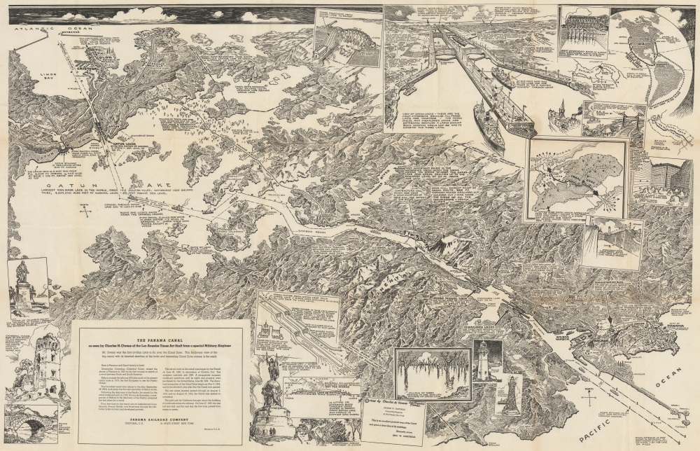
The Panama Canal as seen by Charles H. Owens of the Los Angeles Times Art Staff from special Military Airplane.
1925 (dated) 27.5 x 42.75 in (69.85 x 108.585 cm)
1925 (dated) 27.5 x 42.75 in (69.85 x 108.585 cm)
Description
This is a 1925 Charles H. Owens pictorial bird's-eye view map of the Panama Canal. Owens was the first civilian artist to fly over the canal, offering him a unique perspective and understanding of the canal, resulting in this view.
The first proper attempt to build an interoceanic canal was the vision of the French diplomat Ferdinand de Lesseps. Lesseps had successfully excavated the Suez Canal and saw the construction of the Panama Canal as a grander and more lucrative next project. He incorporated the Compagnie Universelle du Canal Interoceanique on March 3, 1881, which purchased a controlling stake in the existing railroad. Unprepared for the jungle climate, all progress was soon mired by disease, poor planning, political posturing, fraud, and bankruptcy. The Compagnie Universelle du Canal Interoceanique was dissolved by a French bankruptcy court on February 4, 1889, a development that became a major political scandal, largely because many French legislators had been investors in the company.
5 years later, in 1894, the company's assets were reorganized under new investors as Compagnie Nouvelle du Canal de Panama. This organization immediately began new plans to resume excavations, including producing detailed new maps of the project. Ultimately, the French lost control of the canal project to the United States. In 1903, the Hay-Bunau-Varilla Treaty between Panama and the United States granted the U.S. canal-building rights and the sole right to operate and control the Canal Zone. The Compagnie Nouvelle du Canal de Panama sold its holdings (including the railroad) to the United States in 1904, supplanting an earlier failed American venture to build a canal in Nicaragua, and the Panama Canal officially opened under U.S. Management 10 years later in 1914.
Although the Canal was an engineering marvel several decades in the making, its opening was marred by the outbreak of World War I (1914 - 1918). The high death rate of workers (most of whom were from the Caribbean), especially from yellow fever and malaria, also casts a pall over the success of its construction. Still, the canal drastically cut travel times between the Pacific and Atlantic, was a major asset to the Allies during World War II, and helped Panama to become the wealthiest country in Central America on a per capita basis.
The Canal Zone remained a U.S. territory until the 1977 Torrijos-Carter Treaty began a gradual return of the territory to Panamanian sovereignty and management, a process completed in 2000. After coming under full Panamanian control, a third and wider lane of locks was constructed and opened in 2016, allowing larger 'Panamax' container ships to transit the Canal.
A Closer Look
Overlooking the Canal from above the Pacific, this view illustrates the Panama Canal in detail. Dotted and dashed lines highlight the dredged canal, which varies from 5 miles to 500 feet wide in parts of Gatun Lake. The three lock systems (the Gatun Locks, Pedro Miguel Lock, and Miraflores Locks) are illustrated and identified with short captions. The Panama Railroad runs from Colon and Cristobal across the isthmus to Panama City. Insets detail the function of the Gatun Locks, the importance of the watershed to Gatun Lake and the Canal, the Gatun Spillway, and the distance saved by traveling through the canal instead of around Cape Horn.The Panama Canal
The potential for bridging the narrow isthmus of Panama to link the Pacific and Atlantic Oceans had been conceived long before the completion of the canal, but the hurdles standing in the way of such a connection were formidable, including dense jungle, mountains, and tropical diseases. The first major link across the isthmus was the Panama Railroad, built by a group of American investors in the early 1850s to facilitate the California Gold Rush.The first proper attempt to build an interoceanic canal was the vision of the French diplomat Ferdinand de Lesseps. Lesseps had successfully excavated the Suez Canal and saw the construction of the Panama Canal as a grander and more lucrative next project. He incorporated the Compagnie Universelle du Canal Interoceanique on March 3, 1881, which purchased a controlling stake in the existing railroad. Unprepared for the jungle climate, all progress was soon mired by disease, poor planning, political posturing, fraud, and bankruptcy. The Compagnie Universelle du Canal Interoceanique was dissolved by a French bankruptcy court on February 4, 1889, a development that became a major political scandal, largely because many French legislators had been investors in the company.
5 years later, in 1894, the company's assets were reorganized under new investors as Compagnie Nouvelle du Canal de Panama. This organization immediately began new plans to resume excavations, including producing detailed new maps of the project. Ultimately, the French lost control of the canal project to the United States. In 1903, the Hay-Bunau-Varilla Treaty between Panama and the United States granted the U.S. canal-building rights and the sole right to operate and control the Canal Zone. The Compagnie Nouvelle du Canal de Panama sold its holdings (including the railroad) to the United States in 1904, supplanting an earlier failed American venture to build a canal in Nicaragua, and the Panama Canal officially opened under U.S. Management 10 years later in 1914.
Although the Canal was an engineering marvel several decades in the making, its opening was marred by the outbreak of World War I (1914 - 1918). The high death rate of workers (most of whom were from the Caribbean), especially from yellow fever and malaria, also casts a pall over the success of its construction. Still, the canal drastically cut travel times between the Pacific and Atlantic, was a major asset to the Allies during World War II, and helped Panama to become the wealthiest country in Central America on a per capita basis.
The Canal Zone remained a U.S. territory until the 1977 Torrijos-Carter Treaty began a gradual return of the territory to Panamanian sovereignty and management, a process completed in 2000. After coming under full Panamanian control, a third and wider lane of locks was constructed and opened in 2016, allowing larger 'Panamax' container ships to transit the Canal.
Publication History and Census
This map was drawn by Charles H. Owens and published by the Panama Railroad Company in 1925. We note 1 example in OCLC, located at the David Rumsey Map Collection, Stanford University.Cartographer
Charles Hamilton Owens (Feb 16, 1881 - March 3, 1958) was an American painter and illustrator and staff illustrator for the Los Angeles Times. Born in San Francisco, he had a passion for drawing from a young age. After landing a job as a messenger for The San Francisco Examiner, Owens began being taught his trade by the newspaper's illustrators. Although it is unclear exactly where Owens started his career as a newspaper staff artist, his reputation was launched by his detailed sketches of the 1906 San Francisco earthquake and fire for a New York paper, using only wire reports and his knowledge of the city. By 1910, Owens was working for the Los Angeles Examiner. Even at this point in his career, Owens was known for experimenting with new forms of illustration, fusing drawings of events with photographs. Owens's map of the Titanic disaster used a high oblique perspective, 'capturing the earth's sphericity and showing the polar regions on a curving horizon.' By the 1920s, Owens reputation as an artist in Los Angeles had grown beyond the realm of journalism. He had a studio and received commissions for landscapes and had exhibited watercolors of California and Hawaii landscapes. Thus, when Owens began creating his war series in April/May 1942, he had all the necessary skills to create visually striking works. The Los Angeles Times began a series of maps for its readers, which were full-page inserts that would appear every Monday and Saturday. Owens's maps would be included in the Monday issues, and a Rand McNally map would be included on Saturdays. The Rand McNally maps, however, were discontinued on June 27, 1942, but Owens's maps continued to be printed. His last war map was published on September 10, 1945, a little over a week after the Japanese surrender. Owens died in Los Angeles on March 3, 1958. More by this mapmaker...
Condition
Very good. Slight loss at a few fold intersections. Light soiling.
References
Rumsey 7977.000. OCLC 953572716.