This item has been sold, but you can get on the Waitlist to be notified if another example becomes available, or purchase a digital scan.
1889 Figaro Map of Exposition Universelle (World's Fair), Paris, France
Paris-figaro-1889$125.00

Title
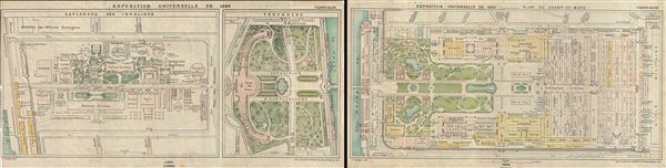
Exposition Universelle de 1889
1889 (dated) 11 x 43 in (27.94 x 109.22 cm)
1889 (dated) 11 x 43 in (27.94 x 109.22 cm)
Description
This is an attractive example of the 1889 Figaro and Petit Journal Map of the 1889 exposition Universelle held in Paris, France. Divided into two parts, the entire plan of the World's Fair covers from Quai d'Orsay to the Avenue de la Motte Picquet, including the Champ de Mars, the Place de Trocadero and part of the Seine River. This incredible detailed map features the eiffel Tower, which served as the entrance arch to the fair and the gauge railway line by the Decauville Manufacturing Company. Although unfinished in 1889, this was the first time patrons were allowed to set foot upon the tower and go up to its second floor platform. Also included is the Galerie des Machines, the largest wide spanned iron structure at the time. Printed and engraved by S. Krakow, this map was published as part of the Guide Blue du Figaro et du Petit Journal, a guide to the 1889 exposition Universelle. Curiously, this guide was so named due to the blue ceiling of the fair's interior courtyard.
Source
Guide Bleu du Figaro et du Petit Journal, (Paris: Figaro), 1889.
Condition
Very good. Original fold lines visible. Typical wear along original folds. Professionally flattened and backed with archival Japanese tissue. Set of two maps.