This item has been sold, but you can get on the Waitlist to be notified if another example becomes available, or purchase a digital scan.
1924 Rand McNally Map of the Philippines
Philippines-mcnally-1924$87.50

Title
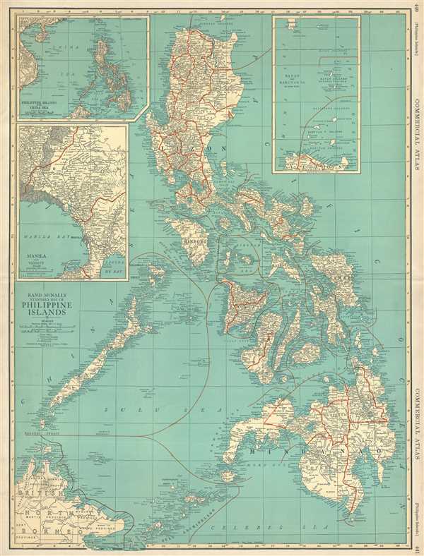
Rand McNally Standard Map of Philippine Islands
1924 (undated) 26 x 20 in (66.04 x 50.8 cm) 1 : 2471000
1924 (undated) 26 x 20 in (66.04 x 50.8 cm) 1 : 2471000
Description
This is a 1924 Rand McNally map of the Philippines. This map illustrates the entire Philippine archipelago and labels all the major islands, including Luzon, Leyte, Panay, Samar, and Mindanao. The map also includes British North Borneo at the lower left corner. The map is incredibly detailed and features hundreds of cities, towns, and villages, and labels several island groups around the central Philippine archipelago. The map offers three insets: one of the Philippines and the China Sea and labels French Indochina; another of the Batan and Babuyan Islands as well as southern Formosa (Taiwan); and the third of Manila and the surrounding area. All three insets are just as detailed as the central.
This map was published by Rand McNally and Company and printed in their 1924 Commercial Atlas of America.
This map was published by Rand McNally and Company and printed in their 1924 Commercial Atlas of America.
Cartographer
Rand, McNally and Co. (fl. 1856 - present) is an American publisher of maps, atlases and globes. The company was founded in 1856 when William H. Rand, a native of Quincy, Massachusetts, opened a print shop in Chicago. Rand hired the recent Irish immigrant Andrew McNally to assist in the shop giving him a wage of 9 USD per week. The duo landed several important contracts, including the Tribune's (later renamed the Chicago Tribune) printing operation. In 1872, Rand McNally produced its first map, a railroad guide, using a new cost effective printing technique known as wax process engraving. As Chicago developed as a railway hub, the Rand firm, now incorporated as Rand McNally, began producing a wide array of railroad maps and guides. Over time, the firm expanded into atlases, globes, educational material, and general literature. By embracing the wax engraving process, Rand McNally was able to dominate the map and atlas market, pushing more traditional American lithographic publishers like Colton, Johnson, and Mitchell out of business. Eventually Rand McNally opened an annex office in New York City headed by Caleb S. Hammond, whose name is today synonymous with maps and atlases, and who later started his own map company, C. S. Hammond & Co. Both firms remain in business. More by this mapmaker...
Source
Commercial Atlas of America/i>, (Chicago: Rand McNally) 1924.
Condition
Very good. English text on verso.
References
Rumsey 5028.000.