This item has been sold, but you can get on the Waitlist to be notified if another example becomes available.
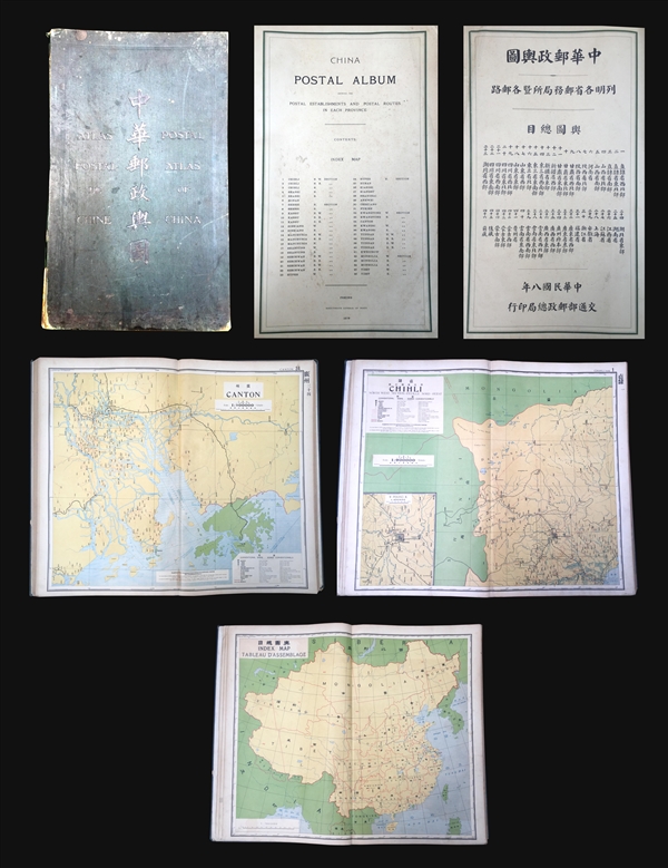
1919 Official Postal Atlas of China (47 Maps)
PostalAtlasChina-guillarmod-1919$4,000.00

Title
Postal Atlas of China. / China postal album, showing the postal establishments and postal routes in each province.
1919 (dated) 24.25 x 15.25 in (61.595 x 38.735 cm)
1919 (dated) 24.25 x 15.25 in (61.595 x 38.735 cm)
Description
A scarce example of the 1919 second edition of the official Chinese Postal Atlas. Compiled by Charles Jacot-Guillarmod, this atlas contains 47 maps, including an index, covering all of Chinese in considerable detail. Most of the maps are presented on a standard projected sale of 1: 900000, but some of the maps are on a larger scale. Most were derived from regional working postal maps.
The history of the Chinese Postal Atlas is closely related to attempts to Romanize the Chinese Postal System. The first atlas followed the 1906 Shanghai Imperial Postal Joint-Session Conference to develop a system of Romanization following Herbert Giles' 'Nanking Syllabary'. The Giles 'Nanking syllabary' was popular with the French dominated Chinese Postal Service which considered the earlier Beijing based system developed by Thomas Francis Wade as too Anglophone. The second edition of the post atlas (the present example) was issued in 1919 following a Ministry of Education system to standardize the Beijing dialect in all elementary schools throughout China. This led to a resurgence of the Wade system, as seen in the present atlas. Nonetheless, in 1931 the French postal co-directory Henri Picard-Destelain ordered a return to the Nanking Syllabary. The Chinese Postal System remained under French management until 1943 when the Japanese invaders ousted A. M. Chapelain, the last French head of the China Post.
There are four known editions of this atlas: 1907-08 (Shanghai, replacing the 1903 postal wall map, 21 maps plus index map), 1919 (Beijing, present example, 47 maps), 1933 (Nanjing), and 1936 (Nanjing). The atlas was compiled by the French topographical engineer Charles Jacot-Guillarmod. It was printed in Beijing by the Government Bureau of Engraving and Printing.
Cartographer
Charles Jacot-Guillarmod (1868 – August 14, 1925) was a Swiss topographical engineer active in the late 19th and early 20th century. Charles was born in Le Chaux-de-Fonds, in the Canton of Neuchatel, Switzerland. He attended the Eidgenössische Technische Hochschule Zürich (ETHZ), where he acquired a degree in Topographical Engineering. After graduating served the Swiss Federal Topographical Bureau from 1890 – 1914, contributed significantly to the Topographical Atlas of Switzerland. He was dismissed from his government topographical posted in 1914. Independent of a paid post he turned his attentions to his interested in high alpine cartography, producing two topographical sketches of Himalayan peaks (K2 and Kanchenjunga) based upon photographs taken by his cousin, the famed mountaineer Jules Jacot-Guillarmod. From 1916 to 1922 he relocated to Beijing where he taught geodesy and topography at the Chinese Army Survey School. There, he was also contracted to compile the 1919 second edition of the China Postal Atlas. When the Chinese government could no longer pay him, he returned to Switzerland in 1923 where he compiled a large scale topographic map of Mount Olympus. His final work was a large scale map of Mount Everest commissioned by the Royal Geographical Society, London, based upon the surveying achievements of a British expedition. More by this mapmaker...
Condition
Good. Elephant folio with 47 maps. Binding gilt stamped linen. Weak and heavy wear on spine. Edge fraying. Contents generally strong. Light soling and age toning.
References
OCLC 79825171.