This copy is copyright protected.
Copyright © 2025 Geographicus Rare Antique Maps
Digital Image: 1945 Sweet SECRET WWII Manuscript Map Villa Verde Trail, Luzon, Philippines
RouteSketchPhilippines-sweet-1945_d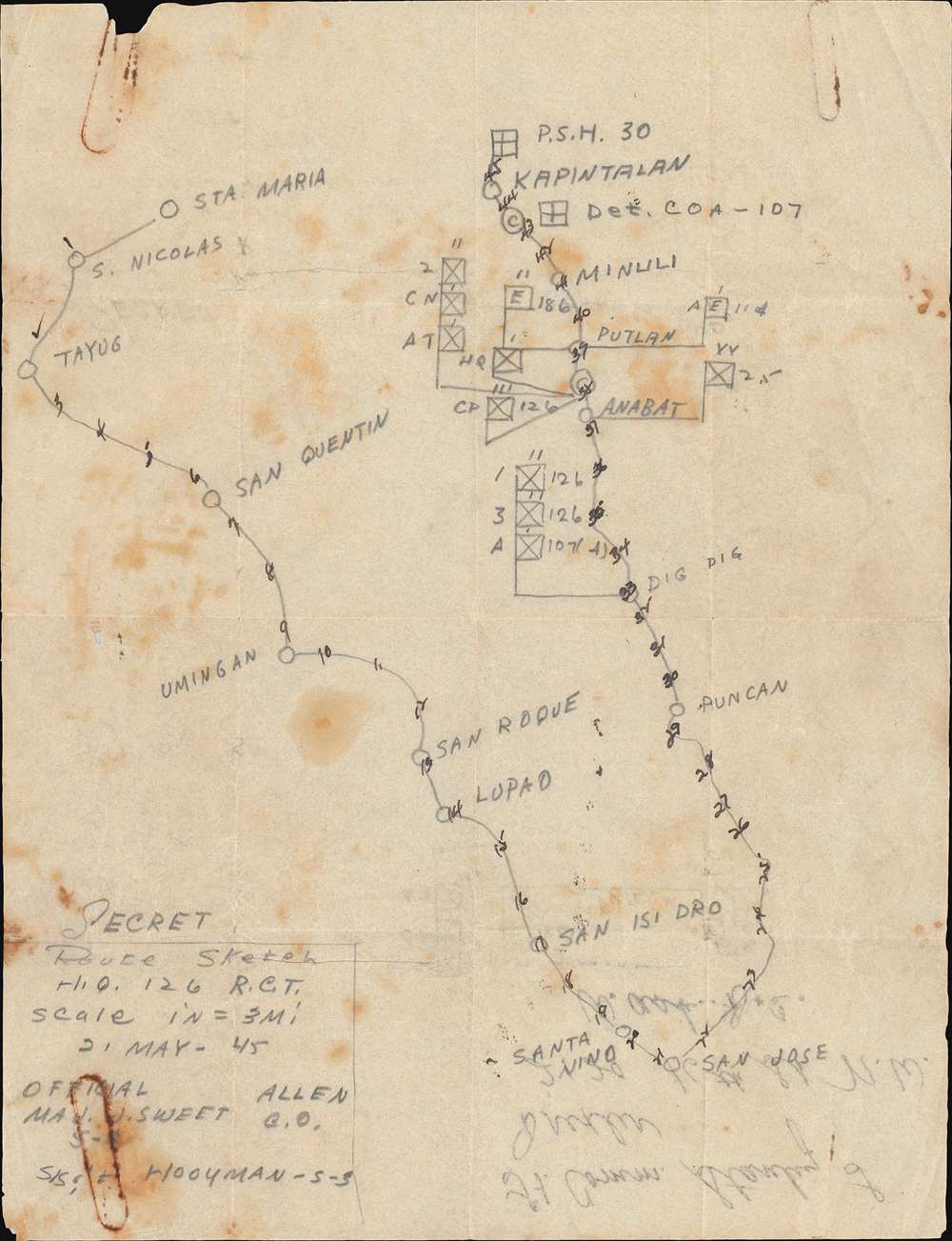

FOR THE ORIGINAL ANTIQUE MAP, WITH HISTORICAL ANALYSIS, CLICK HERE.
Digital Map Information
Geographicus maintains an archive of high-resolution rare map scans. We scan our maps at 300 DPI or higher, with newer images being 600 DPI, (either TIFF or JPEG, depending on when the scan was done) which is most cases in suitable for enlargement and printing.
Delivery
Once you purchase our digital scan service, you will receive a download link via email - usually within seconds. Digital orders are delivered as ZIP files, an industry standard file compression protocol that any computer should be able to unpack. Some of our files are very large, and can take some time to download. Most files are saved into your computer's 'Downloads' folder. All delivery is electronic. No physical product is shipped.
Credit and Scope of Use
You can use your digial image any way you want! Our digital images are unrestricted by copyright and can be used, modified, and published freely. The textual description that accompanies the original antique map is not included in the sale of digital images and remains protected by copyright. That said, we put significant care and effort into scanning and editing these maps, and we’d appreciate a credit when possible. Should you wish to credit us, please use the following credit line:
Courtesy of Geographicus Rare Antique Maps (http://www.geographicus.com).
How Large Can I Print?
In general, at 300 DPI, you should at least be able to double the size of the actual image, more so with our 600 DPI images. So, if the original was 10 x 12 inches, you can print at 20 x 24 inches, without quality loss. If your display requirements can accommodate some loss in image quality, you can make it even larger. That being said, no quality of scan will allow you to blow up at 10 x 12 inch map to wall size without significant quality loss. For more information, it is best consult a printer or reprographics specialist.
Refunds
If the high resolution image you ordered is unavailable, we will fully refund your purchase. Otherwise, digital images scans are a service, not a tangible product, and cannot be returned or refunded once the download link is used.
John Emmett Sweet, Jr. (December 11, 1915 - November 24, 1984) was an American businessman and World War II veteran. Born in Sandusky, Ohio, Sweet graduated from high school in Montrose, Pennsylvania, and attended Lehigh University where he studied metallurgical engineering. He graduated from Lehigh in 1939. Sweet was an officer in the Army Reserve Corps and was called to active duty in January 1942 as a lieutenant. He arrived in Australia in the fall of 1942 and joined the 32nd Division. He and the 32nd Division first saw combat in New Guinea in September 1942. He was awarded the Distinguished Service Cross on for supervising the construction of a bridge under enemy fire during the Buna Campaign in Papua, New Guinea, in December 1942. He spent four years in the Southwest Pacific and fought in numerous campaigns: Buna, Saidor, and Aitape, New Guinea; Morotai, Dutch East Indies; and Leyte and Luzon in the Philippines. By early 1945 he had risen to the rank of Major and was a staff officer of the 126th Infantry Regiment. He was aware the Bronze Star for 'meritorious achievement' on Leyte. Sweet arrived back in the United States in late November 1945. After the war he founded the Tioga Foundry Corporation in 1946 in Oswego, New York. It produced gray iron castings. At its height in the late 1970s, Tioga employed over 200 people. Sweet and Tioga were the first company in New York State to comply with new federal regulations concerning air pollution from smokestacks. He served as its C.E.O. until 1979 and president until 1983. He married Eunice Bowen with whom he had one son. The Tioga foundry closed on October 2, 1987. More by this mapmaker...
Copyright © 2025 Geographicus Rare Antique Maps | Geographicus Rare Antique Maps
This copy is copyright protected.
Copyright © 2025 Geographicus Rare Antique Maps