This copy is copyright protected.
Copyright © 2025 Geographicus Rare Antique Maps
Digital Image: 1636 Hollar View / Map of Siena, Italy
Siena-hollar-1636_d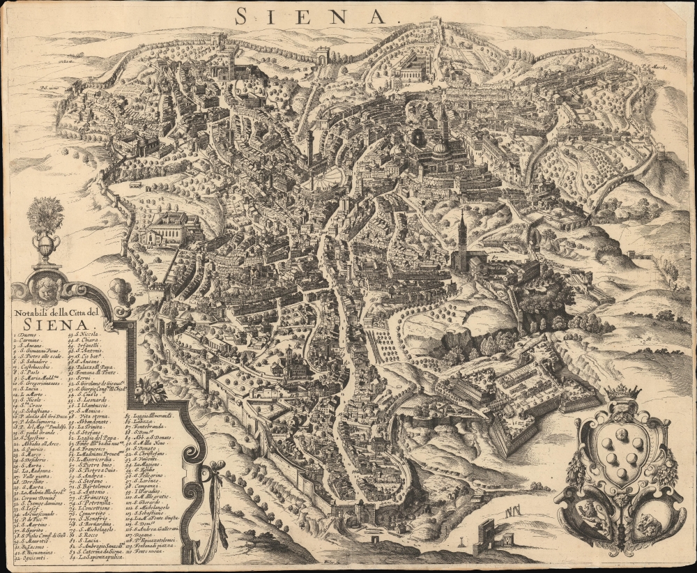

FOR THE ORIGINAL ANTIQUE MAP, WITH HISTORICAL ANALYSIS, CLICK HERE.
Digital Map Information
Geographicus maintains an archive of high-resolution rare map scans. We scan our maps at 300 DPI or higher, with newer images being 600 DPI, (either TIFF or JPEG, depending on when the scan was done) which is most cases in suitable for enlargement and printing.
Delivery
Once you purchase our digital scan service, you will receive a download link via email - usually within seconds. Digital orders are delivered as ZIP files, an industry standard file compression protocol that any computer should be able to unpack. Some of our files are very large, and can take some time to download. Most files are saved into your computer's 'Downloads' folder. All delivery is electronic. No physical product is shipped.
Credit and Scope of Use
You can use your digial image any way you want! Our digital images are unrestricted by copyright and can be used, modified, and published freely. The textual description that accompanies the original antique map is not included in the sale of digital images and remains protected by copyright. That said, we put significant care and effort into scanning and editing these maps, and we’d appreciate a credit when possible. Should you wish to credit us, please use the following credit line:
Courtesy of Geographicus Rare Antique Maps (http://www.geographicus.com).
How Large Can I Print?
In general, at 300 DPI, you should at least be able to double the size of the actual image, more so with our 600 DPI images. So, if the original was 10 x 12 inches, you can print at 20 x 24 inches, without quality loss. If your display requirements can accommodate some loss in image quality, you can make it even larger. That being said, no quality of scan will allow you to blow up at 10 x 12 inch map to wall size without significant quality loss. For more information, it is best consult a printer or reprographics specialist.
Refunds
If the high resolution image you ordered is unavailable, we will fully refund your purchase. Otherwise, digital images scans are a service, not a tangible product, and cannot be returned or refunded once the download link is used.
Wenceslaus Hollar (July 23, 1607 - March 25, 1677) was a Czech / Bohemian artist, etcher and engraver, much of whose life was spent in England. He is known primarily for his engravings and etchings, of which nearly 2800 plates are known. These include a number of excellent maps and city views. He was born in Prague where he initially studied law. The 1620 Sack of Prague during the Thirty Years' War (1618 - 1648) ruined his family's fortunes. Hollar came out of the disruption on the path to becoming an artist. His earliest known works are small engravings, one of which was a copy of a Dürer 'Virgin and Child' and the other is very likely a 1625 outline map of Europe. By 1627 he was in Frankfurt, apprenticed to engraver Matthias Merian (1593 - 1650). Following his apprenticeship, he traveled throughout the Rhineland producing views of towns, castles, and landscapes. His work eventually attracted the notice and patronage of nobleman and art collector Thomas Howard, 21st Earl of Arundel (1585 - 1646). Hollar traveled with Howard from 1636 as a draftsman for the Earl's diplomatic mission to the court of Holy Roman Emperor Ferdinand II (1578 - 1637), as well as to Vienna and Prague. He also accompanied Arundel to England in 1637, where he remained for many years attached to the earl's household. He was not exclusively in the Earl's employ, producing work for many authors and publishers. He produced some very famous views of London following the Great Fire, and was sent in 1668 by the King to Tangier in order to produce views of the towns and forts there. He produced a number of maps for Richard Blome's subscription atlas, the first English atlas actually engraved in England. Unfortunately, his ties with the loyalists during the English Civil War (1642 - 1651) sharply affected his sales, and his patronage declined. He appears not to have been a particularly apt businessman: a friend is recorded as having said of him that he was, 'a very friendly good-natured man as could be, but shiftlesse to the world.' It cannot have helped matters that he only charged a shilling an hour for his labors. Despite the quality of his work, he would die in poverty. More by this mapmaker...
Copyright © 2025 Geographicus Rare Antique Maps | Geographicus Rare Antique Maps
This copy is copyright protected.
Copyright © 2025 Geographicus Rare Antique Maps