This item has been sold, but you can get on the Waitlist to be notified if another example becomes available, or purchase a digital scan.
1863 Harper's Map of the Southern States during the Civil War
SouthernStates-harpers-1863$175.00

Title
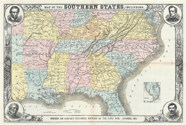
Map of the Southern States, including Rail Roads, County Towns, State Capitals, Country Roads, the Southern Coast from Delaware to Texas, showing the Harbors, Inlets, Forts and Positions of Blockading Ships.
1863 (dated) 21 x 31 in (53.34 x 78.74 cm) 1 : 2970000
1863 (dated) 21 x 31 in (53.34 x 78.74 cm) 1 : 2970000
Description
An impressive and informative 1863 map of the Southern States of the United States at the end of the American Civil War. The map covers from the Chesapeake Bay to, roughly, Cape Canaveral, Florida, and westward along the Gulf Coast as far as Galveston, Texas. An inset sub-map of southern Florida appears in the lower right quadrant. The map is surrounded by an elaborate military themed border with corner medallions bearing portraits of some of the major Union players in the war: Abraham Lincoln, William H. Seward, Winfield Scott, and George B. McClellan.
The map, as the title suggests, focuses on transportation networks, towns small and large, and harbors. The locations of various ships associated with Scott's blockade of southern ports are noted. One of the better maps of the Confederacy at the end of the American Civil War. There are several variants on this map, including two editions with different content and titles published in Harper's Weekly. Published for Harper's History of the Great Rebellion, issued in December of 1863.
The map, as the title suggests, focuses on transportation networks, towns small and large, and harbors. The locations of various ships associated with Scott's blockade of southern ports are noted. One of the better maps of the Confederacy at the end of the American Civil War. There are several variants on this map, including two editions with different content and titles published in Harper's Weekly. Published for Harper's History of the Great Rebellion, issued in December of 1863.
Cartographer
Harper and Brothers (1817 – Present) is New York based American printing publishing firm founded in 1817 by James Harper and his brother John Harper as J. and J. Harper (1817-1833). Their younger brothers Joseph Wesley Harper and Fletcher Harper joined the company around 1926 prompting the 1833 imprint change to Harper and Brothers (1833 – 1962). The firm published countless books, magazines, prints, maps, and more. They began publishing a monthly magazine, Harper's Monthly in 1850. The success of Harper's Monthly led to the introduction of a popular weekly illustrated journal, Harper's Weekly published from 1857 - 1916. They later introduced Harper's Bazar (1867) and Harper's Young People (1879). From about 1899 the business went through a series of permutations selling off some assets and developing others. The company merged with Row, Peters and Company inn 1962, rebranding itself as Harper and Row (1962 – 1990), which was acquired by Marshall Pickering in 1988. It was acquired by Rupert Mordoch (News Corp) and merged with William Collins and Sons in 1990 to form HaprerCollins (1990 – Present), the imprint under which it still publishes. Their original offices were at 331 Franklin Street, roughly below today's Manhattan Bridge. Today they have many offices and are one of the world's largest publishing companies and one of the 'Big Five' English-language publishers. More by this mapmaker...
Source
Harper's History of the Great Rebellion, 1863.
Condition
Good condition. Backed on archival tissue. Wear and some loss along original centerfold. A couple of minor wormholes.
References
Stephenson, Library of Congress Civil War Maps (2nd ed.), 37. OCLC 222028701.