Digital Image: 1928 Harrison Godwin Pictorial Map of North America and Central America
SpanishAmericas-harrisongodwin-1928_d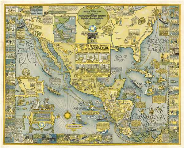

Title
Panama Mail S.S. Co. The Sea Coastes of America shewing the Ports of call of the Panama Mail steamships as the Country there aboutes is lying and situated, with all the havens thereof. Exactly done and corrected with great diligence.
1928 (dated) 27 x 33 in (68.58 x 83.82 cm) 1 : 4900000
1928 (dated) 27 x 33 in (68.58 x 83.82 cm) 1 : 4900000
Description
FOR THE ORIGINAL ANTIQUE MAP, WITH HISTORICAL ANALYSIS, CLICK HERE.
Digital Map Information
Geographicus maintains an archive of high-resolution rare map scans. We scan our maps at 300 DPI or higher, with newer images being 600 DPI, (either TIFF or JPEG, depending on when the scan was done) which is most cases in suitable for enlargement and printing.
Delivery
Once you purchase our digital scan service, you will receive a download link via email - usually within seconds. Digital orders are delivered as ZIP files, an industry standard file compression protocol that any computer should be able to unpack. Some of our files are very large, and can take some time to download. Most files are saved into your computer's 'Downloads' folder. All delivery is electronic. No physical product is shipped.
Credit and Scope of Use
You can use your digial image any way you want! Our digital images are unrestricted by copyright and can be used, modified, and published freely. The textual description that accompanies the original antique map is not included in the sale of digital images and remains protected by copyright. That said, we put significant care and effort into scanning and editing these maps, and we’d appreciate a credit when possible. Should you wish to credit us, please use the following credit line:
Courtesy of Geographicus Rare Antique Maps (http://www.geographicus.com).
How Large Can I Print?
In general, at 300 DPI, you should at least be able to double the size of the actual image, more so with our 600 DPI images. So, if the original was 10 x 12 inches, you can print at 20 x 24 inches, without quality loss. If your display requirements can accommodate some loss in image quality, you can make it even larger. That being said, no quality of scan will allow you to blow up at 10 x 12 inch map to wall size without significant quality loss. For more information, it is best consult a printer or reprographics specialist.
Refunds
If the high resolution image you ordered is unavailable, we will fully refund your purchase. Otherwise, digital images scans are a service, not a tangible product, and cannot be returned or refunded once the download link is used.
Cartographer S
William Harrison Godwin (March 21, 1899 - January 11, 1984), who went by Harrison, was an American cartoonist, pictorial map artist, and hotelier active in California during the early to middle parts of the 20th century. Harrison was born in Hackettstown, New Jersey. Harrison was a cartoonist with the Los Angeles Examiner and published two daily strips. With regard to cartographic material he published just three maps, San Francisco, Hollywood, and North America, all between the years of 1927 and 1929. The San Francisco and Hollywood maps were first and second maps in a planned series of American cities, each taking some three months to complete. Curiously, no further maps in the series materialized. In addition to his cartoon work Harrison, in partnership with his brother Fred, owned Carmel-by-the-Sea's La Playa Hotel, where Harrison worked as a manager. Later, in 1940, Harrison sold his interest in the La Playa and acquired full ownership of the Pine Inn, also in Carmel and still active. Harrison and Fred Godwin and are credited with popularizing Carmel as a tourist destination. Little else is known of his life. More by this mapmaker...
Max Heinrich William Schmidt (February 17, 1850 - May 22, 1936) was a German American, engraver, lithographer, and publisher. Born in Schaemhaum, Germany, Schmidt left home at 14 when he chose to go to sea as a cabin boy instead of pursuing a career in medicine, as was family tradition. He spent the next 7 years traveling the world and developed his artistic skills aboard ship, keeping a meticulously lettered logbook. He arrived in San Francisco in 1871 and left his ship. First finding work in a restaurant, Schmidt soon began working for San Francisco lithographers, and spent the next three years working for Korbell Brothers, Grafton, T. Brown (San Francisco's only African American lithographer), and other San Francisco firms and engravers. He set up his own shop in 1874, called Schmidt and Buehler, in partnership with Frederick Buehler. They made pictorial cuts for local newspapers. Schmidt was on his own two years later, working under the name M. Schmidt and Company and producing stock certificates and colored lithographic labels. Schmidt incorporated the firm in 1883 under the name Schmidt Label and Lithographic Company. His factory burned in 1884 and again in 1886. In 1899, Schmidt acquired the lithographic firm Dickman-Jones and H.S. Crocker's label department and formed a new firm called the Mutual Label Company and Lithographic Company. In the early 1900s, Schmidt expanded to Los Angeles, when the Lost Angeles Lithographic Company and the Western Lithograph Company became associated with Mutual. In 1906, the Great San Francisco Earthquake and Fire destroyed his company. He soon rebuilt and named the new firm the Schmidt Lithograph Company. Under this imprint, he printed all there of Harrison Godwin's (1899 - 1984) famous pictorial maps. Schmidt continued to find success, and eventually expanded to Southern California, Texas, Utah, the Pacific Northwest, Florida, and Honolulu, making labels for producer and packers in all these areas. Although the firm did produce posters, booklets, and other forms of commercial lithography, it mainly focused on labels. The Stecher-Traung Company bought Schmidt Lithograph in 1966 and formed Stecher-Truang-Schmidt, which operated until 1994. Learn More...
References
The Huntington Library, 325580. OCLC 21609899.