This copy is copyright protected.
Copyright © 2025 Geographicus Rare Antique Maps
Digital Image: 1878 Hayden Geological Map of Green River, Snake River, and Jackson Lake Region
WYIDUTGeological-hayden-1878_d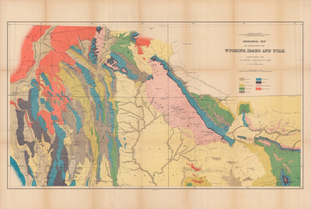


FOR THE ORIGINAL ANTIQUE MAP, WITH HISTORICAL ANALYSIS, CLICK HERE.
Digital Map Information
Geographicus maintains an archive of high-resolution rare map scans. We scan our maps at 300 DPI or higher, with newer images being 600 DPI, (either TIFF or JPEG, depending on when the scan was done) which is most cases in suitable for enlargement and printing.
Delivery
Once you purchase our digital scan service, you will receive a download link via email - usually within seconds. Digital orders are delivered as ZIP files, an industry standard file compression protocol that any computer should be able to unpack. Some of our files are very large, and can take some time to download. Most files are saved into your computer's 'Downloads' folder. All delivery is electronic. No physical product is shipped.
Credit and Scope of Use
You can use your digial image any way you want! Our digital images are unrestricted by copyright and can be used, modified, and published freely. The textual description that accompanies the original antique map is not included in the sale of digital images and remains protected by copyright. That said, we put significant care and effort into scanning and editing these maps, and we’d appreciate a credit when possible. Should you wish to credit us, please use the following credit line:
Courtesy of Geographicus Rare Antique Maps (http://www.geographicus.com).
How Large Can I Print?
In general, at 300 DPI, you should at least be able to double the size of the actual image, more so with our 600 DPI images. So, if the original was 10 x 12 inches, you can print at 20 x 24 inches, without quality loss. If your display requirements can accommodate some loss in image quality, you can make it even larger. That being said, no quality of scan will allow you to blow up at 10 x 12 inch map to wall size without significant quality loss. For more information, it is best consult a printer or reprographics specialist.
Refunds
If the high resolution image you ordered is unavailable, we will fully refund your purchase. Otherwise, digital images scans are a service, not a tangible product, and cannot be returned or refunded once the download link is used.
Ferdinand Vandeveer Hayden (September 7, 1829 - December 22, 1887) was an American geologist remembered for leading late 19th century pioneering surveying expedition in the Rocky Mountains and served as a doctor in the Union Army during the U.S. Civil War. Born in Westfield, Massachusetts, and discovered a fascination with nature and wildlife in his youth. He studied at Oberlin College and graduated in 1850, then attended the Albany Medical College and earned his degree in 1853. While at Albany, Hayden garnered the attention of Professor James Hall, then the state geologist of New York. Professor Hall convinced Hayden to join an expedition to the Nebraska Territory, where he collected fossils and studied geology. He accompanied expeditions led by Gouverneur K. Warren in 1856 and 1857 and the Raynolds Expedition of 1860 led by Captain William F. Raynolds. He served as an army surgeon during the U.S. Civil War and rose to become the chief medical officer of the Army of the Shenandoah. After the war, Hayden resumed working on geologic and geographic surveys in the Nebraska and Western Territories and was appointed geologist-in-chief of the United States Geological and Geographical Survey of the Territories in 1867. Hayden led the first federally funded geological survey into the Yellowstone Region in northwestern Wyoming in 1871 under orders from Secretary of the Interior Columbus Delano. The expedition included fifty men, including painter Thomas Moran and Civil War photographer William Henry Jackson. Hayden's report on the expedition, Preliminary Report of the United State Geological Survey of Montana and Portions of Adjacent Territories; Being a Fifth Annual Report of Progress played an instrumental role in persuading Congress to establish Yellowstone as the first U.S. National Park. More by this mapmaker...
Frederick Miller Endlich (June 14, 1851 - July 17, 1899) was a mineralogist, chemist, and mining engineer. Born in Germany, he received a doctorate from the Universität Tübingen and emigrated to the United States of America. From 1872 to 1880, he worked at the Smithsonian Institution and participated in the U.S. Geological and Geographical Survey of the Territories. Afterwards, he served as a mining engineer consultant throughout the American West. Learn More...
Albert Charles Peale (April 1, 1849 - December 5, 1914) was a geologist, mineralogist, and member of the U.S. Geological and Geographical Survey of the Territories (also known as the Hayden Survey). He studied at Philadelphia's Central High School and trained to become a physician, earning a medical degree though never practicing medicine. In 1871, he joined Hayden and would spend most of the next thirty years with the Survey of the Territories and its successor, the U.S. Geological Survey. He later worked as a paleobotanist at the Smithsonian. Several natural features in Wyoming, Idaho, and Utah are named for him. Learn More...
Orestes Hawley St. John (1841 - 1921) was a geologist notable for his work with the U.S. Geological and Geographical Survey of the Territories (also known as the Hayden Expedition). He began his career with the Geological Survey of Illinois, with which he was intermittently associated from the 1860s until 1883. He also served as the principal geologist for the Second Geological Survey of Iowa from 1862 to 1868. Given his extensive experience, he was chosen to join the Hayden Expedition and led parties that surveyed the Wind River Mountains, portions of the Gros Ventre Range, the Wyoming Range, and the Snake River Valley. Learn More...
Julius (Julien) Bien (September 27, 1826 - December 21, 1909) was a German-Jewish lithographer and engraver based in New York City. Bien was born in Naumburg, Germany. He was educated at the Academy of Fine Arts, Cassell and at Städel's Institute, Frankfurt-am-Main. Following the suppression of the anti-autocratic German Revolutions of 1848, Bien, who participated in the pan-German movement, found himself out of favor in his home country and joined the mass German immigration to the United States. Bien can be found in New York as early as 1849. He established the New York Lithographing, Engraving & Printing Company in New York that focused on the emergent chromo-lithograph process - a method of printing color using lithographic plates. His work drew the attention of the U.S. Government Printing Office which contracted him to produce countless government maps and surveys, including the Pacific Railroad Surveys, the census, numerous coast surveys, and various maps relating to the American Civil War. Bien also issued several atlases both privately and in conjunction with a relation, Joseph Bien. At the height of his career Bien was elected president of the American Lithographers Association. After his death in 1909, Bien's firm was taken over by his son who promptly ran it into insolvency. The firm was sold to Sheldon Franklin, who, as part of the deal, retained the right to publish under the Julius Bien imprint. In addition to his work as a printer, Bien was active in the New York German Jewish community. He was director of the New York Hebrew Technical Institute, the New York Hebrew Orphan Asylum, and president of the B'nai B'rith Order. Learn More...
Copyright © 2025 Geographicus Rare Antique Maps | Geographicus Rare Antique Maps
This copy is copyright protected.
Copyright © 2025 Geographicus Rare Antique Maps