This item has been sold, but you can get on the Waitlist to be notified if another example becomes available, or purchase a digital scan.
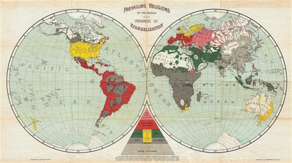
1894 Baker and Taylor Map of the World's Religions
WorldReligonsEvangelization-bakertaylor-1894$137.50

Title
Prevailing Religions of the World and Progress of Evangelization.
1894 (dated) 14.5 x 26 in (36.83 x 66.04 cm) 1 : 70000000
1894 (dated) 14.5 x 26 in (36.83 x 66.04 cm) 1 : 70000000
Description
A curious 1894 map of the world that attempts to map the religious deportment and the progress of evangelization. The map, which is printed on waxed linen, uses bold printed color to identify various religious groups: 'Greek and Oriental' (Orthodox Christianity), Roman Catholic, Protestant Christians, Mohammedans (Muslims), Jews, Pagans, and Heathens. According to the author's triangular reasoning, the bulk of the world's population is either Pagan or Heathen. It is unclear her what the author means by 'Pagan' vs. 'Heathen.' He has assigned most tribal parts of the world: Africa, parts of South America, the Pacific Northwest, Inuit Alaska, New Guinea, and parts of the East Indies, to the 'Pagan' category while India and East Asia are 'Heathen.' One possibility is that he uses 'heathen' to refer to peoples who may have been exposed to Christianity, but not as yet converted, as opposed to those who have no exposure to Christian teachings. Be that as it may, this map was issued by the Protestant Reverend Arthur Tappan Pierson (1837-1911) for his work on missionary activity, The New Acts of the Apostles. The map was drawn by the Baker and Taylor Company in 1984 and printed by Ketterlinus of Philadelphia and New York
Source
Pierson, A. T., The New Acts of the Apostles, 1894.
Condition
Very good. Light soiling. Original fold lines.
References
OCLC 71015320.

