1661 Du Val Map(s) of Africa
Africa-duval-1661$2,000.00

Title
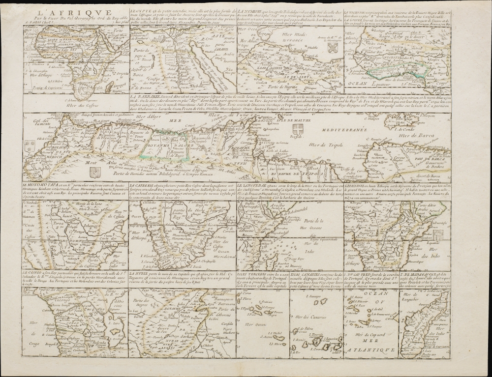
L'Afrique par le Sieur Du Val, Geographe Ord. du Roy.
1661 (dated) 15.5 x 19.5 in (39.37 x 49.53 cm)
1661 (dated) 15.5 x 19.5 in (39.37 x 49.53 cm)
Description
This is Pierre Duval's 1661 mapping of Africa, a comprehensive and detailed single-sheet presentation achieved by dividing the sheet up into 15 separate maps: one map of the entire African continent along with 14 regional maps.
Coastlines, rivers, lakes, mountains, settlements (including a handful of European outposts), and other features are labeled throughout. Although focusing on coastal regions with which Europeans were most familiar, some attempts have been made to map the interior of the continent, somewhat atypical for European maps of the time. Du Val was not far off in some of his speculations, such as the source of the Nile being a lake deep in the interior of central or even central-southern Africa.
In sum, this is an extremely rare and interesting piece for serious collectors of Africa, reflecting the state of European geographic knowledge and cartographic speculation in the mid-17th century.
A Closer Look
The regional maps display Egypt, Northwest Africa (Numidie), West Africa (La Nigritie), a long horizontal view of North Africa (La Barbarie), Southeast Africa (Monomotapa), South Africa (La Cafrerie), the Horn of Africa (Le Languebar), Abyssinia, Congo, Nubia, Terceira Island and the Azores, the Canary Islands, the Cape Verde Islands, and Madagascar. Each includes a short description of the people, geography, and/or political situation of the region.Coastlines, rivers, lakes, mountains, settlements (including a handful of European outposts), and other features are labeled throughout. Although focusing on coastal regions with which Europeans were most familiar, some attempts have been made to map the interior of the continent, somewhat atypical for European maps of the time. Du Val was not far off in some of his speculations, such as the source of the Nile being a lake deep in the interior of central or even central-southern Africa.
In sum, this is an extremely rare and interesting piece for serious collectors of Africa, reflecting the state of European geographic knowledge and cartographic speculation in the mid-17th century.
Publication History and Census
This map was prepared by Pierre du Val and originally published by Jacques Lagniet in 1661. Betz relates that this map is part of a set of four continent maps with regional maps produced by Duval, dated to circa 1656, based on the map of the Americas (' L'Amerique par P. Du Val Geographe du Roy'). This is the third state of the Africa map, with the visible erasure of 'Laignet sur le quay de la Megisserie au fort leuseq' from the title, suggesting it was printed somewhat after 1661. Regardless of state, this is a very rare work and is only listed in the OCLC among the holdings of the Bibliothèque nationale de France, the University of Michigan, and the University of Wisconsin-Milwaukee.CartographerS
Pierre Du Val (May 19, 1619 - September 29, 1683) was a French cartographer and publisher active in Paris during the middle part of the 17th century. He was born Abbeville, Picardie, France, where his father, also Pierre, was a merchant, consul, and alderman. His mother was Marie Sanson, sister of Nicolas Sanson d'Abbeville (1600-1667), the leading French cartographer of his day. Du Val and probably apprenticed in Sanson's workshops. Afterwards, in Paris, he studied geography under Jean-Baptiste Gault, who later became the Bishop of Marseilles. He counseled M. Henri of Savoye, abbot of St. Sorlin, and M. Gilles Bouraut, bishop of Aire and later Evreux, in matters of science and geography. Du Val became Geographe ordinaire to Louis XIV in 1650. His first atlas, the 1654 Cartes Geographiques Methodiquement Divisees, contained few of his own maps and was mostly compiled from reissues of maps by other cartographers. His early work focused on atlases and geographical treatises, but later, he turned his attentions to large separate issue, often multi-sheet maps. After his death in 1683, his widow, Marie Desmaretz, continued his business at least until 1684, after which it passed to his daughters (either Marie-Angelique or Michelle), who published until at least 1688. He is the elder brother of Placide de Sainte Hélène (1648 - 1734), Placidium Augustinum, an Augustine monk and geographer. More by this mapmaker...
Jacques Lagniet (1620 - April 10, 1675) was a French engraver, caricaturist, publisher, and dealer in prints and maps based in Paris. He was best known for middle-market prints focusing on everyday life and lore, as well as socio-critical satire. He was most active from 1647 to 1660 from office at rue St-Martin, parish of St-Nicolas-des-Champs and later near For-l'Évêque, on the Quai de la Mégisserie. He was survived by a daughter, Françoise Perronne Lagniet, who married the engraver, Pierre Picart. Learn More...
Condition
Excellent. Original outline color.
References
OCLC 494400407. Betz, R.,The Mapping of Africa: a Cartobibliography of Printed Maps of the African Continent to 1700 ('t Goy-Houten: Hes and De Graaf) 2007, #85.3.