Digital Image: 1745 De Wit / Ottens Map of Africa and the Arabian Peninsula
AfricaArabia-ottens-1745_d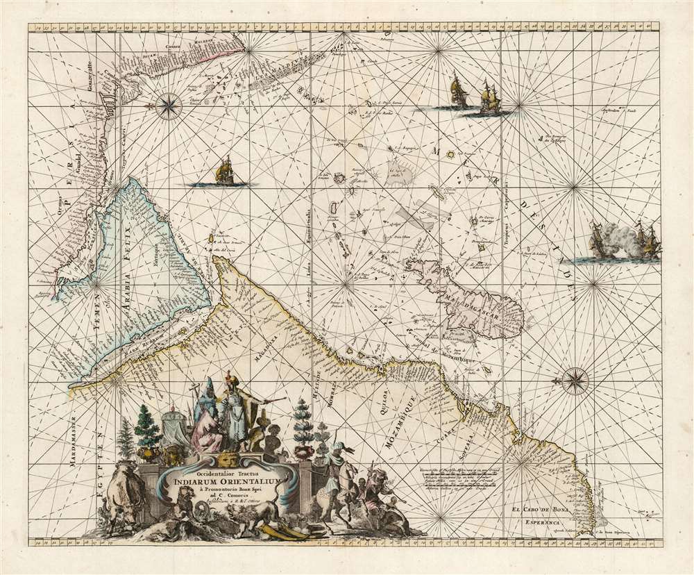

Title
Occidentalior Tractus Indiarum Orientalium à Promontorio Bonae Spei ad C. Comorin.
1745 (undated) 17.25 x 21 in (43.815 x 53.34 cm) 1 : 16726000
1745 (undated) 17.25 x 21 in (43.815 x 53.34 cm) 1 : 16726000
Description
FOR THE ORIGINAL ANTIQUE MAP, WITH HISTORICAL ANALYSIS, CLICK HERE.
Digital Map Information
Geographicus maintains an archive of high-resolution rare map scans. We scan our maps at 300 DPI or higher, with newer images being 600 DPI, (either TIFF or JPEG, depending on when the scan was done) which is most cases in suitable for enlargement and printing.
Delivery
Once you purchase our digital scan service, you will receive a download link via email - usually within seconds. Digital orders are delivered as ZIP files, an industry standard file compression protocol that any computer should be able to unpack. Some of our files are very large, and can take some time to download. Most files are saved into your computer's 'Downloads' folder. All delivery is electronic. No physical product is shipped.
Credit and Scope of Use
You can use your digial image any way you want! Our digital images are unrestricted by copyright and can be used, modified, and published freely. The textual description that accompanies the original antique map is not included in the sale of digital images and remains protected by copyright. That said, we put significant care and effort into scanning and editing these maps, and we’d appreciate a credit when possible. Should you wish to credit us, please use the following credit line:
Courtesy of Geographicus Rare Antique Maps (http://www.geographicus.com).
How Large Can I Print?
In general, at 300 DPI, you should at least be able to double the size of the actual image, more so with our 600 DPI images. So, if the original was 10 x 12 inches, you can print at 20 x 24 inches, without quality loss. If your display requirements can accommodate some loss in image quality, you can make it even larger. That being said, no quality of scan will allow you to blow up at 10 x 12 inch map to wall size without significant quality loss. For more information, it is best consult a printer or reprographics specialist.
Refunds
If the high resolution image you ordered is unavailable, we will fully refund your purchase. Otherwise, digital images scans are a service, not a tangible product, and cannot be returned or refunded once the download link is used.
Cartographer S
Frederik de Wit (1629 - 1706) was a Dutch Golden Age cartographer active in the second half of the 17th and the early 18th centuries. De Wit was born of middle class Protestant stock in the western Netherlandish town of Gouda. He relocated to Amsterdam sometime before 1648, where he worked under Willem Blaeu. His first attributed engraved map, a plan of Haarlem for Antonius Sanderus' Flandria Illustrata, was issued around this time. He struck out on his own in 1654. The first chart that De Wit personally both drew and engraved was most likely his 1659 map of Denmark, REGNI DANIÆ Accuratissima delineatio Perfeckte Kaerte van ‘t CONJNCKRYCK DENEMARCKEN. His great wall map of the world and most famous work, Nova Totius Terrarum Orbis Tabula appeared one year later. Following the publication of his wall map De Wit quickly rose in prominence as a both cartographer and engraver. He married Maria van der Way in 1661 and through her became a citizen of Amsterdam in 1662. Around this time he also published his first major atlas, a composite production ranging in size from 17 to over 150 maps and charts. Other atlases and individual maps followed. In 1689 De Wit was granted a 15 year Privilege by the Dutch States General. (An early copyright that protected the recipient's rights to print and publish.) He was recognized with the honorific 'Good Citizen' in 1694. De Wit died in 1706 after which his wife Maria continued publishing his maps until about 1710. De Wit's son, Franciscus, had no interest in the map trade, instead choosing to prosper as a stockfish merchant. On her own retirement, Maria sold most De Wit maps and plates at a public auction. Most were acquired by Pieter Mortier and laid the groundwork for the 1721 rise of Covens and Mortier, the largest Dutch cartographic publishing house of the 18th century. More by this mapmaker...
Joachim Ottens (1663 - 1719) and his sons Renier (? - 1750) and Joshua (? - 1765) Ottens were prominent Dutch booksellers and map publishers from about 1680 to 1790. Joachim, the founder of the firm, was initially employed as a copperplate engraver by Frederick de Wit. In 1711 Joachim founded his own firm. Though Joachim died only a few years later, his sons Renier and Joshua took over the firm and presided over its most prolific period. The Ottens family's most notable contribution to cartography were its enormous made-to-order multi-volume atlases such as the Atlas Major. Some examples of the Atlas are compiled from over 800 separately issued maps. Learn More...
Romeyn de Hooghe (Septemer 10, 1645 – June 10, 1708) was a Dutch engraver, portrait artist, caricaturist, painter, and sculptor active in Amsterdam during the second half of the 17th century and opening years of the 18th century. De Hooghe was born in Amsterdam and revealed an early talent for all forms of visual arts. He became known caricaturist and is admired today as one of the first great graphic satirists. During his life he was criticized for his proclivity towards humorous tongue-in-cheek subjects. He nonetheless developed a following and produced a prolific amount of work, some 5000 engravings. He was a member of the Confrerie Pictura in 1662 and 1683. Cartographically he is best known for his decorative border work. His disciples were Filibert Bouttats (1654-after 1731), Filibertus Bouttats (1635–1707), Frans Decker, François Harrewijn, Jacobus Harrewijn, Aernout Naghtegael, Laurens Scherm, and Adriaen Schoonebeek. De Hooghe died in Haarlem on June 10, 1708. Much of his work continued to be republished posthumously. Learn More...
References
OCLC 796367907. Norwich, O. I., Norwich's Maps of Africa: An Illustrated and Annotated Cartobibliography, 256. (De Wit 1680).