This item has been sold, but you can get on the Waitlist to be notified if another example becomes available, or purchase a digital scan.
1869 Garnier Map of the World's Air and Ocean Currents
AirOceanCurrents-garnier-1860$137.50

Title
Tableau Général des Courants Atmosphériques et Océaniques, ou Résumé des Observations Meteorologiques et Nautique les plus récentes, recueillies à la surface du Globe par divers voyageurs, pour déterminer la direction des Vents et la marche des Courants sous les différentes latitudes et aux différentes époques de l'année.
1862 (dated 1860) 22.5 x 29 in (57.15 x 73.66 cm) 1 : 70000000
1862 (dated 1860) 22.5 x 29 in (57.15 x 73.66 cm) 1 : 70000000
Description
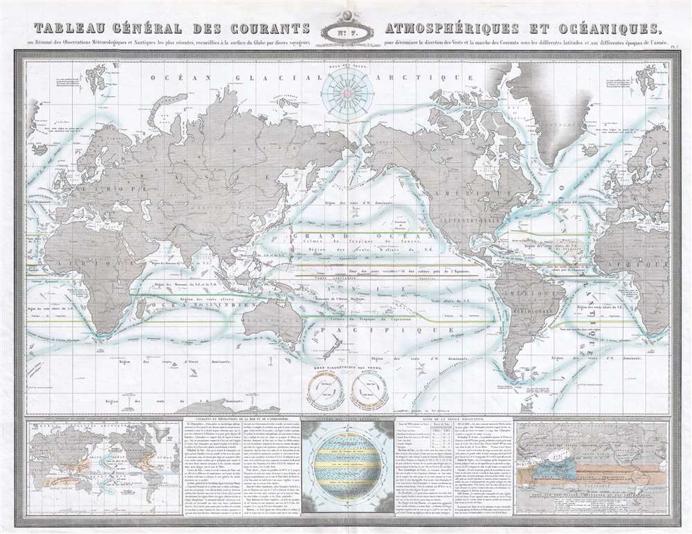
This is an 1860 F.A. Garnier thematic map of the world's winds and ocean currents. The map depicts the world from Greenland across Europe and Asia to the Pacific Ocean and the Americas and then across the Atlantic Ocean to Europe and Africa. As this map's purpose is to illustrate the winds and ocean currents, little detail is present. Most of the countries of the world are labeled, along with several major world capitals, but international borders are almost entirely ignored. Garnier traces the paths of ocean currents in a brilliant shade of blue, highlighting, among numerous others, the Gulf Stream along the East Coast of North America. Each current is labeled and the direction in which it flows is indicated by arrows.
The world's winds are illustrated differently, however. Garnier does not focus on specific winds, unlike the specific ocean currents, but on zones. These zones are marked on the main map and labeled as regions, such as the 'region of dominant westerly winds', 'region of the northeast trade winds', 'region of the southeast trade winds'.
Along the bottom border, Garnier has included a section composed of five different parts. Two of these parts are textual explanations concerning wind, the atmosphere, ocean currents, and other pertinent information. The other sections are smaller world maps, illustrating other aspects of worldwide weather patterns. The map situated in the lower left corner highlights regions around the world where hurricanes, cyclones, and typhoons occur; the one in the center illustrates winds on a global scale; and the one on the right depicts the distribution of rain and snow throughout the world.
This map was created by F.A. Garnier in 1860 and published by the Veuve Jules Renouard in Garnier's Atlas Spheroidal et Universel de Geographie in 1862.
Cartographer
F.A. Garnier (1803 - 1863) was a French cartographer who published the Atlas sphéroidal et universel de géographie in 1862 as his only work. It is said that he spent fifteen years creating the maps for the atlas. More by this mapmaker...
Source
Garnier, F. A. Atlas Spheroidal et Universel de Geographie, (Paris: Veuve Jules Renouard) 1862.
Condition
Very good. Even overall toning. Verso repairs to centerfold separations. Blank on verso.
References
Rumsey 5023.007. OCLC 51328599.