This item has been sold, but you can get on the Waitlist to be notified if another example becomes available.
1904 Alaskan Boundary Tribunal 'Atlas of Award' - Signed by Tribunal Members
AlaskanBoundaryTribunal-govprinting-1904$1,250.00


Title
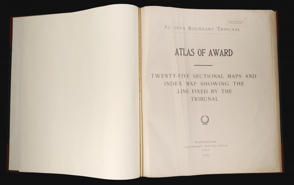
Atlas of Award Twenty-five sectional maps and index map showing the line fixed by the Tribunal / Senate Document No. 162. 58th Congress, 2d Session.
1904 (dated) x in (0 x 0 cm)
1904 (dated) x in (0 x 0 cm)
Description
An exceptional item, this atlas recounting the work and decision of the 1903 Alaska Boundary Tribunal is signed multiple times by the members of the tribunal. The dispute, instigated by the Klondike Gold Rush, was a sore spot in Canada-U.S. relations for years. Its resolution in favor of the U.S., with the deciding vote cast by a British member of the tribunal, simultaneously resolved the conflict and improved Anglo-American relations.
This arrangement entailed a major problem little appreciated at the time, in that it would bring British territory tantalizingly close to the Pacific but without an accessible outlet to the ocean. A further complicating factor was that the Russian-American Company and Hudson's Bay Company signed an agreement in 1839 for the latter to access a strip of the Pacific shoreline in exchange for agricultural products, which the Russians sorely desired. Unfortunately, for future British and Canadian claims, contemporary governments in both Ottawa and London did not consider this commercial arrangement a territorial claim. After the United States purchased Alaska in 1867 (the same year the British North America Act unified Canada as a single dominion), the Canadian government requested a proper survey to map the remote region, but the U.S. thought it costly and unnecessary. Still, in 1898, the governments in Ottawa and Washington, D.C., agreed on a compromise boundary, but the provincial government of British Columbia rejected it.
By this time, external events took over, as the region was completely upended after the 1896 Klondike gold discovery. The resulting gold rush brought tens of thousands of (mostly American) prospectors to the border region between Alaska and Canada, suddenly thrusting the boundary uncertainty into the limelight. Canada's lack of control over a route to a seaport was potentially a major liability. One of the most direct routes near one of the narrowest strips of American territory was the Lynn Canal, south of Skagway and Dyea (visible on the index map). When the local Canadian North-West Mounted Police tried to assert control over the head of the canal, they were overwhelmed by the number of arrivals and retreated to avoid any violent incidents. (At the beginning of the gold rush, there were only 22 Mounties assigned to the entire region). More officers were transferred to the Klondike, but their numbers were still insufficient. Law and order were impossible to uphold, and the Canadian government became concerned that they might lose sovereignty over the Klondike entirely. To back up the Mounties, the Canadian government used regular army troops to create a new 200-man unit called the Yukon Field Force to secure Canadian sovereign claims and maintain law and order among the prospectors as best as possible. Although no battles took place, national tensions were extremely high. The presence of rifles, artillery, and Gatling guns at the unit's base at Fort Selkirk clarified that the Canadians were prepared for a worst-case scenario.
By the following year (1899), the gold rush began to wind down. The prospectors moved elsewhere (many to a new gold rush around Nome, Alaska), diminishing the crisis somewhat. However, the whole episode showed the importance of having a surveyed and demarcated border, and the fundamental territorial dispute still had not been settled. Thus, the 1903 Hay-Herbert Treaty established the Alaskan Boundary Tribunal to resolve these issues. The tribunal consisted of six elder statesmen: three Americans (Elihu Root, the sitting Secretary of War, sitting senator Henry Cabot Lodge, and ex-senator George Turner), two Canadians (Sir Louis A. Jette, Lieutenant Governor of Quebec, and Allen B. Aylesworth, a prominent barrister who replaced John Douglas Armour, who died during the tribunal proceedings), and one Brit (the barrister and judge Richard Everard Webster, better known by his title Baron Alverstone). Although respected as a statesman, the inclusion of Root raised eyebrows, as he was a sitting member of the U.S. President's cabinet and could hardly be impartial. The Canadians also saw Turner as a nobody and Lodge as partisan, incapable of objective analysis. In any event, the tribunal proceeded, often through turgid debates of the meaning of particular French terms used in earlier treaties. They examined a wide range of historical sources, recognizing that early maps of the region were inadequate. In the end, the Americans and Canadians voted as expected, but the British member of the tribunal, Baron (later Lord) Alverstone, sided with the American position, with qualifications. The most maximalist claims of the Americans were rejected and sovereignty over the Portland Channel (or Portland Canal) was divided in half.
Although most historians have deemed the decision fair, and the resolution helped improve U.S.-British relations, starting a long trend that has continued to the present. Canadians at the time were incensed, feeling betrayed by London and cheated by the Americans. In fact, although the Canadian tribunal members signed the maps in the present atlas, they refused to sign the 'award' (decision). However, Britain signed a subsequent treaty with the U.S. in 1906, solidifying the results of the tribunal. The dispute has been credited with helping foster a distinct sense of Canadian identity and nationalism, leading to the Statute of Westminster of 1931 and, ultimately, full independence in 1982.
A Closer Look
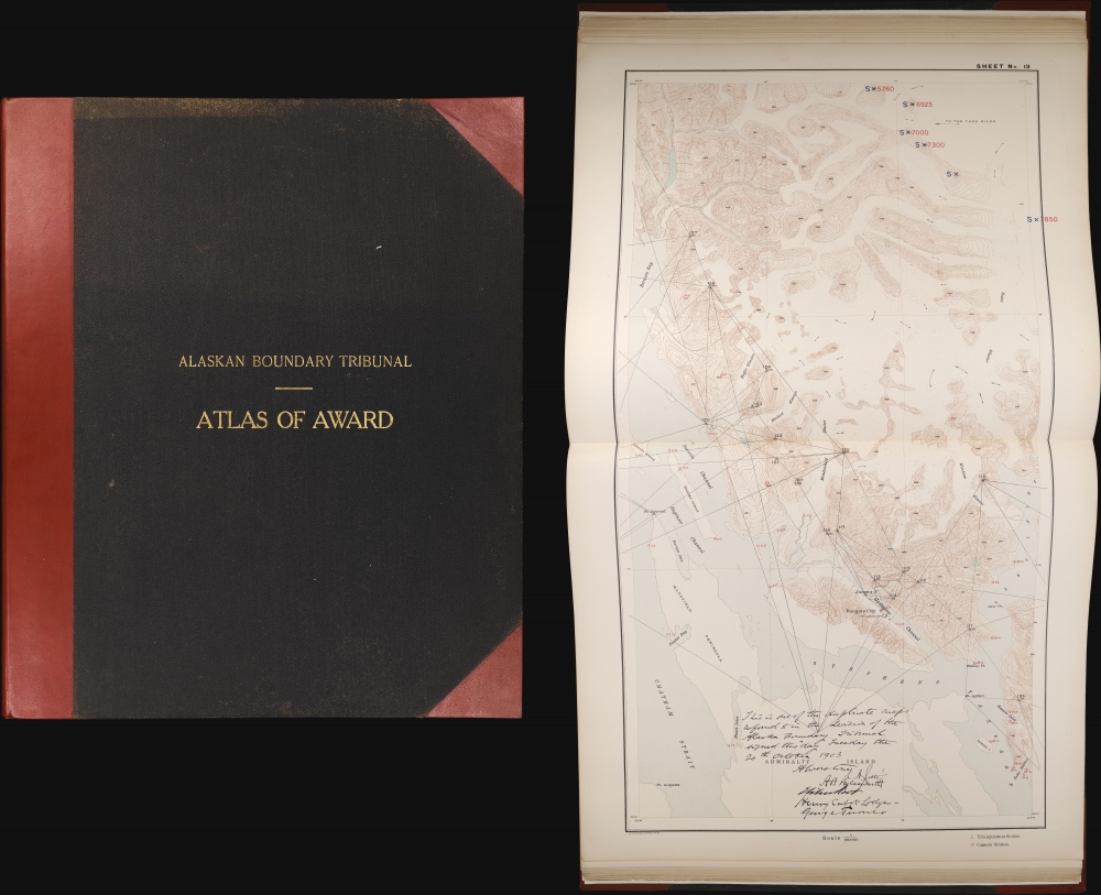
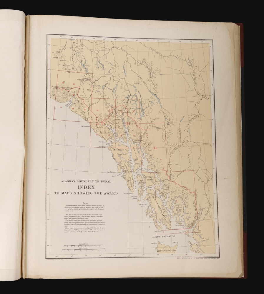
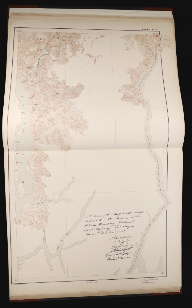
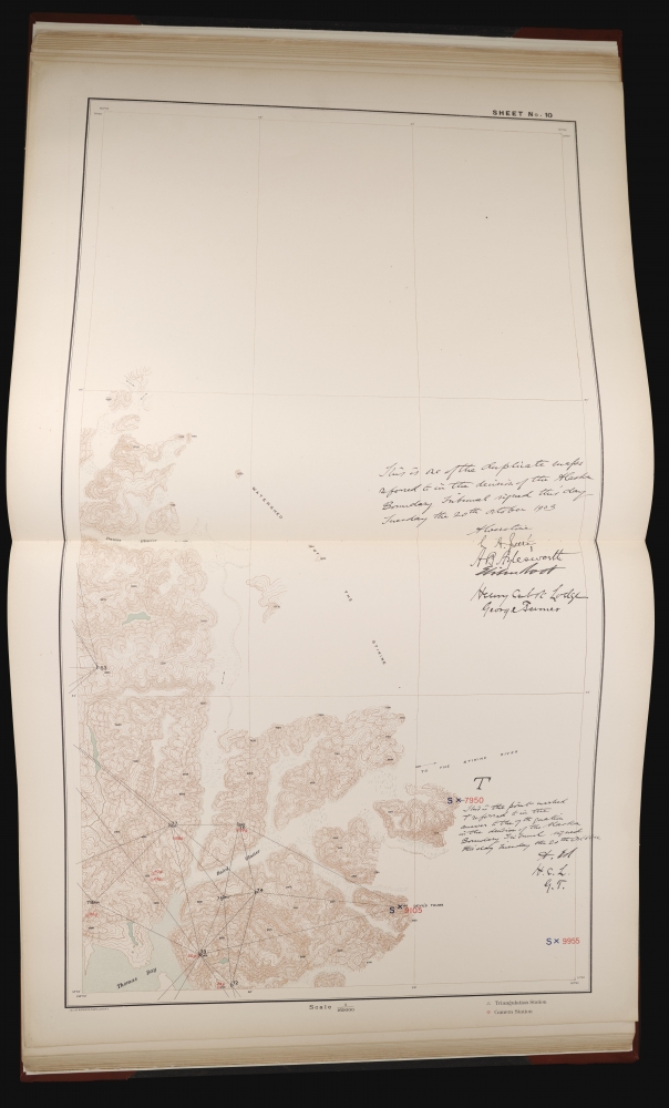
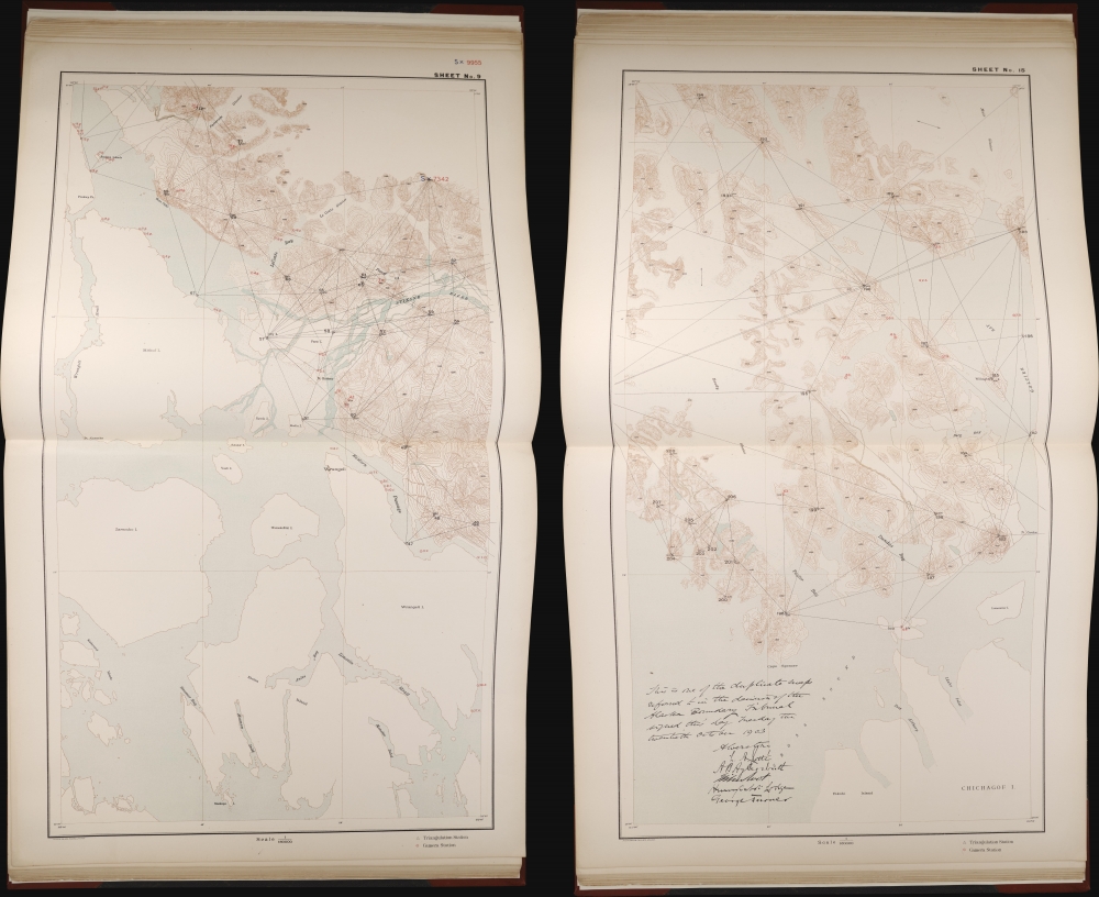
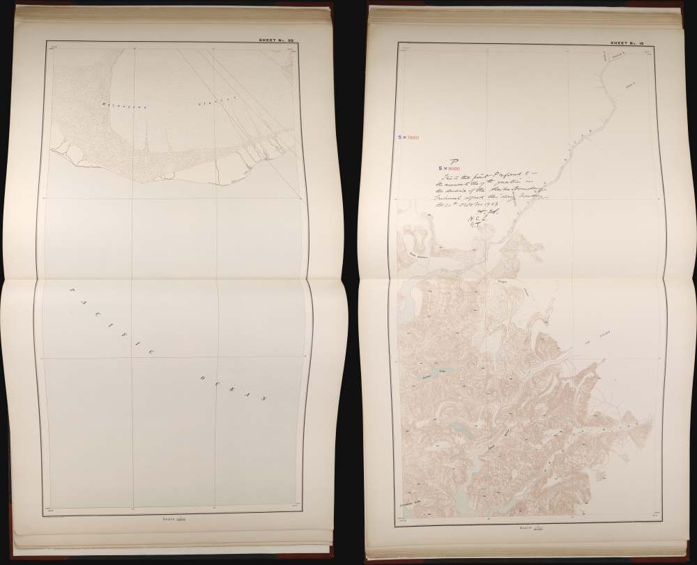
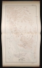
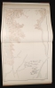
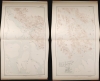
The atlas contains twenty-five maps of specific parts of the Alaska-Canada border (at a scale of 1:160000) along with an index map. Coverage on the index map embraces southern Alaska from roughly the Malaspina Glacier and Mt. St. Elias, where the border begins to diverge from the 141st parallel west and follow (roughly) the coastline to Queen Charlotte Island, or more specifically, Cape Muzon and Dixon Entrance just south of Prince of Wales Island, where Alaska's border dives into the sea, leaving British Columbia between it and the contiguous United States. Rivers, lakes, bays, inlets, islands, mountains, and other features are noted, along with the occasional settlement. The locations of the section maps on the following pages are indicated on the index map, along with the areas covered by five maps originally produced by an 1895 British Alaskan Boundary Commission also devoted to settling the border (published in Alaskan boundary atlas 1895 Maps of British Commission by the Canadian Department of the Interior). Several of the section maps are signed by the tribunal members (listed and discussed below).The Alaskan Boundary Tribunal
The Alaskan Boundary Tribunal of 1903 was an international arbitration panel that resolved a territorial dispute between the United States and Canada over the boundary of Alaska. The origins of the dispute date to the 1820s, when the Russian Empire and the United Kingdom signed the Anglo-Russian Convention of 1825 (also known as the Treaty of St. Petersburg), which defined the boundary between the two empires' domains as a line running:north along the channel called Portland Channel as far as the point of the continent where it strikes the 56th degree of north latitude; from this last-mentioned point, the line of demarcation shall follow the summit of the mountains situated parallel to the coast as far as the point of intersection of the 141st degree of west longitude.Knowing that this division was less than precise, especially 'the summit of the mountains situated parallel to the coast,' the agreement assumed future negotiations to solidify the border in the still-largely-unexplored region.
This arrangement entailed a major problem little appreciated at the time, in that it would bring British territory tantalizingly close to the Pacific but without an accessible outlet to the ocean. A further complicating factor was that the Russian-American Company and Hudson's Bay Company signed an agreement in 1839 for the latter to access a strip of the Pacific shoreline in exchange for agricultural products, which the Russians sorely desired. Unfortunately, for future British and Canadian claims, contemporary governments in both Ottawa and London did not consider this commercial arrangement a territorial claim. After the United States purchased Alaska in 1867 (the same year the British North America Act unified Canada as a single dominion), the Canadian government requested a proper survey to map the remote region, but the U.S. thought it costly and unnecessary. Still, in 1898, the governments in Ottawa and Washington, D.C., agreed on a compromise boundary, but the provincial government of British Columbia rejected it.
By this time, external events took over, as the region was completely upended after the 1896 Klondike gold discovery. The resulting gold rush brought tens of thousands of (mostly American) prospectors to the border region between Alaska and Canada, suddenly thrusting the boundary uncertainty into the limelight. Canada's lack of control over a route to a seaport was potentially a major liability. One of the most direct routes near one of the narrowest strips of American territory was the Lynn Canal, south of Skagway and Dyea (visible on the index map). When the local Canadian North-West Mounted Police tried to assert control over the head of the canal, they were overwhelmed by the number of arrivals and retreated to avoid any violent incidents. (At the beginning of the gold rush, there were only 22 Mounties assigned to the entire region). More officers were transferred to the Klondike, but their numbers were still insufficient. Law and order were impossible to uphold, and the Canadian government became concerned that they might lose sovereignty over the Klondike entirely. To back up the Mounties, the Canadian government used regular army troops to create a new 200-man unit called the Yukon Field Force to secure Canadian sovereign claims and maintain law and order among the prospectors as best as possible. Although no battles took place, national tensions were extremely high. The presence of rifles, artillery, and Gatling guns at the unit's base at Fort Selkirk clarified that the Canadians were prepared for a worst-case scenario.
By the following year (1899), the gold rush began to wind down. The prospectors moved elsewhere (many to a new gold rush around Nome, Alaska), diminishing the crisis somewhat. However, the whole episode showed the importance of having a surveyed and demarcated border, and the fundamental territorial dispute still had not been settled. Thus, the 1903 Hay-Herbert Treaty established the Alaskan Boundary Tribunal to resolve these issues. The tribunal consisted of six elder statesmen: three Americans (Elihu Root, the sitting Secretary of War, sitting senator Henry Cabot Lodge, and ex-senator George Turner), two Canadians (Sir Louis A. Jette, Lieutenant Governor of Quebec, and Allen B. Aylesworth, a prominent barrister who replaced John Douglas Armour, who died during the tribunal proceedings), and one Brit (the barrister and judge Richard Everard Webster, better known by his title Baron Alverstone). Although respected as a statesman, the inclusion of Root raised eyebrows, as he was a sitting member of the U.S. President's cabinet and could hardly be impartial. The Canadians also saw Turner as a nobody and Lodge as partisan, incapable of objective analysis. In any event, the tribunal proceeded, often through turgid debates of the meaning of particular French terms used in earlier treaties. They examined a wide range of historical sources, recognizing that early maps of the region were inadequate. In the end, the Americans and Canadians voted as expected, but the British member of the tribunal, Baron (later Lord) Alverstone, sided with the American position, with qualifications. The most maximalist claims of the Americans were rejected and sovereignty over the Portland Channel (or Portland Canal) was divided in half.
Although most historians have deemed the decision fair, and the resolution helped improve U.S.-British relations, starting a long trend that has continued to the present. Canadians at the time were incensed, feeling betrayed by London and cheated by the Americans. In fact, although the Canadian tribunal members signed the maps in the present atlas, they refused to sign the 'award' (decision). However, Britain signed a subsequent treaty with the U.S. in 1906, solidifying the results of the tribunal. The dispute has been credited with helping foster a distinct sense of Canadian identity and nationalism, leading to the Statute of Westminster of 1931 and, ultimately, full independence in 1982.
Publication History and Census
This atlas was prepared by the U.S. Government Printing Office in 1904. The index map was drawn by the U.S. Coast and Geodetic Survey, while most of the maps in the atlas were printed by Julius Bien and Co., and the text was prepared by the Government Printing Office in Washington, D.C. Although the atlas appears in some 30 institutional collections in the OCLC, this autographed example is likely one-of-a-kind.Condition
Complete with 26 maps (25 sheets plus a supplementary sheet), many with manuscript notes and signatures. Rebound.
References
OCLC 1269433029.