This item has been sold, but you can get on the Waitlist to be notified if another example becomes available, or purchase a digital scan.
1867 Depot de la Marine Nautical Chart or Map of Alexandria, Egypt
Alexandria-depot-1867$200.00

Title
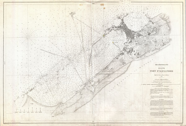
Mer Mediterranee Egypte Port D'Alexandrie.
1867 (dated) 25 x 37 in (63.5 x 93.98 cm)
1867 (dated) 25 x 37 in (63.5 x 93.98 cm)
Description
This is a rare French nautical chart or map of Alexandria, Egypt dating to 1867 (updated to 1882). Prepared by the French Depot des Cartes et Plans de la Marine, this map offers extraordinary detail both inland and at sea. In the harbor there are countless depth soundings in meters, sailing notations, and references to shoals, lights, and navigational points. Inland there is a wealth of information regarding the city proper, important buildings, topography, gardens, streets, palaces, walled fortifications, and surrounding villages. Detailed textual sailing instructions in the lower right quadrant.
Cartographer
Dépôt des Cartes et Plans de la Marine (fl. 1720 - present), often called the Dépôt de Marine, was a French hydrographic mapping organization founded in 1720 under Charles-Hercule of Albert de Luynes (1674 - 1734). Much like the U.S. Coast Survey, the British Admiralty, and the Spanish Deposito Hydrografico, the Dépôt was initiated as a storehouse and distribution center of existing nautical and marine charts. Eventually the Dépôt initiated its own mapping activities in an attempt to improve and expand upon existing material. Some of the more prominent cartographers and hydrographers associated with the of Dépôt des Cartes were, Philippe Buache, Jacques-Nicholas Bellin, Giovanni Rizzi-Zannoni, Rigobert Bonne, and Jean Nicolas Buache. More by this mapmaker...
Condition
Very good. Original centefold. This chart has been used for actual navigation and does have a few pencil marks which can be removed upon request. Blank on verso.