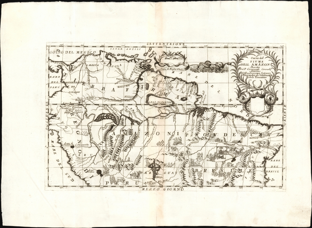
1689 Coronelli Map of the Amazon River and Northern South America
Amazon-coronelli-1689
Title
1689 (undated) 11 x 18 in (27.94 x 45.72 cm) 1 : 14100000
Description
A Closer Look
The map spans from the Pacific coast of Peru to the Atlantic; part of the Atlantic coast of Brazil is revealed, as is the northern coast of South America spanning from Panama Guiana, and northern Brazil. The courses of the Orinoco and Amazon rivers dominate. The Amazon River is shown from an indeterminate source in Ecuador to its mouth. At the southern extreme, the headwaters of the Paraguay River are identified as Lago Xarayes. In addition to its depiction of the region's rivers, the map is filled with Coronelli's characteristic vignettes capturing the indigenous population in activities spanning sugar harvesting and processing, war, hunting, and cannibalism. There also appear depictions of animals: a pair of tapirs, a crane-like bird with a fantastic tropical plant, and lions.Laguna de Xarayes
The mythical Laguna de Xarayes is illustrated here as the northern terminus, or source, of the Paraguay River. The Xarayes, a corruption of 'Xaraies' meaning 'Masters of the River', were an indigenous people occupying what are today parts of Brazil's Matte Grosso and the Pantanal.El Dorado?
The region between the Orinoco and the Amazon were thought by Europeans, going back to the sixteenth century, to hide a supposed kingdom of gold, El Dorado; Raleigh's expedition encountered the vast Parima flood plain, which resembled a great inland sea offering trade connections between the two great rivers; gold trinkets amongst the indigenous peoples there convinced Raleigh that they originated from the fabled El Dorado. Many cartographers throughout the seventeenth century presented Parima as a massive lake, with the city of El Dorado or Manoa on its shores. Coronelli includes the lake but not the city of gold, adding a note that the lake was now believed a fable.Publication History and Census
The engraving has been dated as early as 1689; it was produced for inclusion in Coronelli's Citta, fortezze, isole, e porti principali dell'Europa . The work appeared in editions dated 1694 and 1710 as well, with no noted changes. The map is listed in about a dozen institutions and appears on the market from time to time.Cartographer
Vincenzo Maria Coronelli (August 16, 1650 - December 9, 1718) was an important 17th-century cartographer and globe maker based in Venice. Coronelli was born the fifth child of a Venetian tailor. Unlikely to inherit his father's business, he instead apprenticed in Ravenna to a woodcut artist. Around 1663, Coronelli joined the Franciscan Order and, in 1671, entered the Venetian convent of Saint Maria Gloriosa dei Frari. Coronelli excelled in the fields of cosmography, mathematics, and geography. Although his works include the phenomenal Atlante Veneto and Corso Geografico, Coronelli is best known for his globes. In 1678, Coronelli was commissioned to make his first major globes by Ranuccio II Farnese, Duke of Parma. Each superbly engraved globe was five feet in diameter. Louis IV of France, having heard of the magnificent Parma globes, invited Coronelli to Paris, where from 1681-83 he constructed an even more impressive pair of globes measuring over 12 feet in diameter and weighing 2 tons each. The globes earned him the patronage of Louis XIV and privileged access to French cartographic information from Jesuit sources in the New World, particularly Louisiana. Coronelli returned to Venice and continued to publish globes, maps, and atlases, which were admired all over Europe for their beauty, accuracy, and detail. He had a particular fascination for the Great Lakes region, and his early maps of this area were unsurpassed in accuracy for nearly 100 years after their initial publication. He is also well known for his groundbreaking publication of the first accurate map depicting the sources of the Blue Nile. At the height of his career, Coronelli founded the world's first geographical society, the Accademia Cosmografica degli Argonauti, and was awarded the official title Cosmographer of the Republic of Venice. In 1699, in recognition of his extraordinary accomplishment and scholarship, Coronelli was also appointed Father General of the Franciscan Order. The great cartographer and globe maker died in Venice at the age of 68. His extraordinary globes can be seen today at the Bibliothèque Nationale François Mitterrand in Paris, Biblioteca Marciana in Venice, the National Library of Austria, the Globe Museum in Vienna, the Library of Stift Melk, the Special Collections Library of Texas Tech University, as well as lesser works in Trier, Prague, London, and Washington D.C. Coronelli's work is notable for its distinctive style, which is characterized by the high-quality white paper, dark intense impressions, detailed renderings of topographical features in profile, and numerous cartographic innovations. More by this mapmaker...

