This copy is copyright protected.
Copyright © 2025 Geographicus Rare Antique Maps
Digital Image: 1728 Stöcklein Map of the Amazon based on its Earliest Firsthand Mapping
Amazon-stocklein-1728_d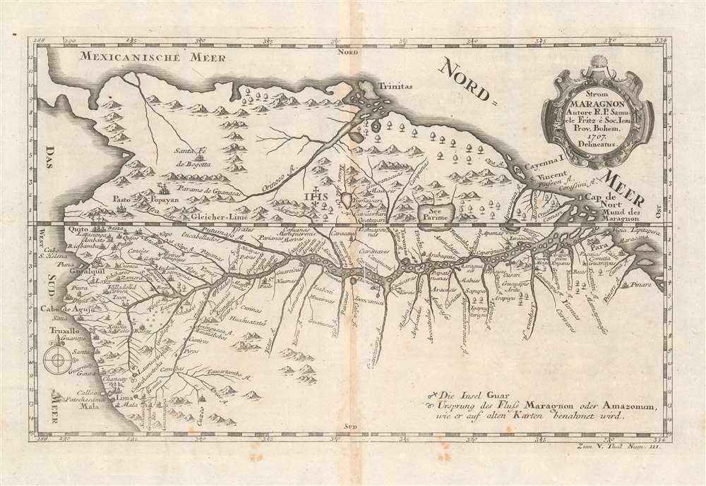

FOR THE ORIGINAL ANTIQUE MAP, WITH HISTORICAL ANALYSIS, CLICK HERE.
Digital Map Information
Geographicus maintains an archive of high-resolution rare map scans. We scan our maps at 300 DPI or higher, with newer images being 600 DPI, (either TIFF or JPEG, depending on when the scan was done) which is most cases in suitable for enlargement and printing.
Delivery
Once you purchase our digital scan service, you will receive a download link via email - usually within seconds. Digital orders are delivered as ZIP files, an industry standard file compression protocol that any computer should be able to unpack. Some of our files are very large, and can take some time to download. Most files are saved into your computer's 'Downloads' folder. All delivery is electronic. No physical product is shipped.
Credit and Scope of Use
You can use your digial image any way you want! Our digital images are unrestricted by copyright and can be used, modified, and published freely. The textual description that accompanies the original antique map is not included in the sale of digital images and remains protected by copyright. That said, we put significant care and effort into scanning and editing these maps, and we’d appreciate a credit when possible. Should you wish to credit us, please use the following credit line:
Courtesy of Geographicus Rare Antique Maps (http://www.geographicus.com).
How Large Can I Print?
In general, at 300 DPI, you should at least be able to double the size of the actual image, more so with our 600 DPI images. So, if the original was 10 x 12 inches, you can print at 20 x 24 inches, without quality loss. If your display requirements can accommodate some loss in image quality, you can make it even larger. That being said, no quality of scan will allow you to blow up at 10 x 12 inch map to wall size without significant quality loss. For more information, it is best consult a printer or reprographics specialist.
Refunds
If the high resolution image you ordered is unavailable, we will fully refund your purchase. Otherwise, digital images scans are a service, not a tangible product, and cannot be returned or refunded once the download link is used.
Joseph Stöcklein [Stoecklein] (July 30, 1676 – December 28, 1733) was a Jesuit priest, missionary, and scholar active in the late 17th and early 18th centuries. He was born in Oettingen, Germany and joined the Jesuit order in Vienna around 1700. He served as a priest in military encampments where he became popular as a preacher. Afterwards he became the head of the Jesuit library in Graz, Switzerland, a position he maintained for six years. During this tenure he began work on his opus, the Welt-Bott, a vast compilation of Jesuit missionary letters and narratives translated into vernacular German intended both to glorify the priesthood and share valuable information about the world. Today this work is exceedingly rare. More by this mapmaker...
Samuel Fritz (1654 - 1728), was a Jesuit missionary born in Trutnov, Bohemia, what is now part of the Czech Republic. He took orders with the Society of Jesus, or Jesuits, in 1673. As a young Jesuit with missionary ambitions he was educated in humanistics, philosophy, and probably cartography. In 1683, he requested a missionary post in the New World and was sent to Quito where his superior, Father Lorenzo Lucero, assigned him to incorporate the Omagua tribes between the Rio Negro and the Napo River into the Maynas Missions. He spent 42 years in South America, and founded thirty-eight missions along the length of the Amazon River, in the country between the Rio Napo and Rio Negrond. His aid having been sought by the Viceroyalty of Peru in its boundary dispute with the State of Brazil, Fritz mapped the missionary territory on the Upper Maranon between Peru and Quito, resulting the first approximately correct chart of the Maranon territory. Both his map and the account of his imprisonment as a suspected Spanish spy were widely disseminated in the 18th century. Learn More...
Copyright © 2025 Geographicus Rare Antique Maps | Geographicus Rare Antique Maps
This copy is copyright protected.
Copyright © 2025 Geographicus Rare Antique Maps