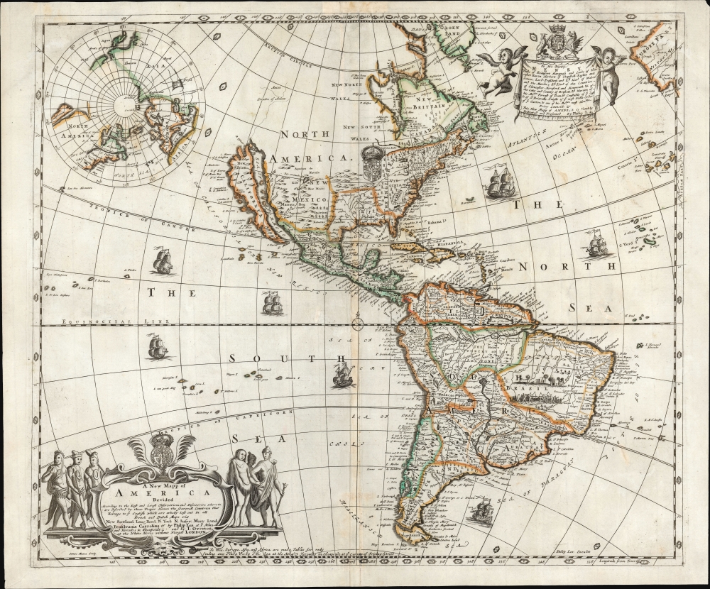
Title
A New Mapp of America Devided According to the Best and latest Observations and Discoveries wherein are discribed by their Proper Names the seaverall Countries that Belonge to ye English which are wholly left out in all French and Dutch maps viz New Scotland, Long Iland, N. York, N. Jarsey, Mary Land, Pensilvania Carrolina etc. by Philip Lea at ye Atlas and Hercules in Cheapside and by J. Overton at the White Horse without Newgat London.
1688 (undated)
18.75 x 22 in (47.625 x 55.88 cm)
1 : 38000000
Description
This is a rare, important, separately issued 1688 English map of America, printed by Philip Lea and John Overton. It was first issued in 1684, explicitly as a rebuttal to French and Dutch maps and their representation of European spheres of influence in North America. It is the first general map of America to name Philadelphia, and presents a boldly exaggerated depiction of 'The English Empire' in North America.
A Closer Look
The map presents the Western Hemisphere, from as far west as the Marianas (as mapped by the Spanish in the 16th century) and as far east as the coast of Spain, the Canaries, and the Cape Verde islands. In general form, the map appears to follow the Dutch, specifically the 1675 Novissima et Accuratissima Totius Americae Descriptio of Frederick de Wit. (The shape of the insular California, as well as the coastline and detail of South America, tends to support this as a starting point.) However, the eastern half of North America diverges sharply from any precursor map. From the vicinity of northern Florida up into the Canadian Maritimes, there are massive alterations. The innovations spurred by French exploration of the St. Lawrence River and Great Lakes have been dispensed with, Hudson's Bay has been reduced in size, and what Great Lakes appear are in open-ended and schematic form.
Instead, from Florida to the St. Lawrence, the eastern part of North America is dominated by what Lea terms 'The English Empire,' whose northern border hugs the St. Lawrence and whose northwestern limits are undefined. Rather than present a western border, Lea obscures that region with the British Royal Arms. On the north bank of the St. Lawrence is a meager Canada or New Franc (sic), hemmed in on the north by New Brittain, New North Wales, and New South Wales.
The space thus afforded to England - at the expense of French territorial claims - allows Lea to lavish detail on the British Colonies in North America. Carolina, Virginia, Pennsylvania, New Jersey, New York, New England, and New Scotland are detailed. (Maryland, abbreviated MAR L, proves a typographic challenge.) Cities of New York, Boston, Kennebeck, New London, Albany, and (for the first time on a map of the Americas) Philadelphia are all detailed here.The North Parts of the World
In the upper left corner of the engraving is a north-polar projection, suggesting a presumed open sea connection between the Atlantic and the Pacific. Beyond, the map reinforces the idea of the great size of 'The English Empire' in North America, versus a virtually invisible Canada. To look at this map and compare it with the dominant French maps of the period, it would surprise no one at all that the two powers would soon be at war over these same territories.Embellishments and Aids to the User
The lower left of the map contains a handsomely engraved cartouche, surmounted with the British Royal Arms and flanked by native warriors. (Also, the text of this cartouche contains Lea's amended 'Atlas and Hercules in Cheapside' address, part of what distinguishes this as a second state). In the upper right, supported with putti and bearing the dedicatee's arms, is a dedication to Henry, the Duke of Beaufort. (The presence of the dedication suggests a publication no later than 1689: A favorite of King James II and a member of Charles II's Privy Council, he refused to swear allegiance to William of Orange and fell out of favor.)
A probable distinguishing factor between the first and second states of this map are the letter coordinates set in the border of the map and the lettered medallions appearing about the map itself. These were keyed to passages in the booklet Alphabet of America, which this map accompanied in 1688 but which had not been published before 1687. It is unlikely that these features would have been added without the associated text. (Although since no surviving copies of the 1684 state can be scrutinized, we have to accept the possibility that the booklet was planned for but was not completed in time for appearance in Lea's 1685 advertisements.)Publication History and Census
This map was first engraved by James Moxon for publication by Philip Lea in 1684, as indicated by that publisher's advertisements, but no examples of that issue of the map have survived. The present c. 1688 issue was published separately and in conjunction with Philip Lea's Alphabet of America as well as accompanying maps of Europe, Asia, and Africa. We see only two examples of the separate map cataloged in OCLC, at the JCB and the Bibliothèque National de France. It has appeared on the market only a handful of times in the past forty years.
CartographerS
Philip Lea (c. 1660 - 1700) was an English cartographer, globemaker, instrument maker, and publisher, active in London. Little is known of his early life, and what we do know is mainly to be found in his work. He apprenticed with Robert Morden in 1675. He produced his own maps as well as revising those of others (a long list, including not only Morden but also Moll, Ogilby, and Seller.) He collaborated directly with Morden, Ogilby, and Overton on an array of maps and globes. After his death in 1700 his wife, Ann Lea, took over the business and ran it for a quarter of a century. More by this mapmaker...
John Overton (1640 - 1708) was an English cartographer and map publisher active in the late 16th and early 17th century. He shop, a noted on many of his maps, was at the sign of the Whitehorse without Newgate. While little of Overton's cartographic work was original, he did fill an important gap by republishing the work of various influential cartographers of the previous generation. Overton acquired the map plates of Peter Stent, who died of the Plague in 1665, and published his first atlas around 1670. In 1700 he acquired, from Christopher Brown, the map plates originally produced for the John Speed firm. John passed his business to his sons, Henry Overton (fl. 1707 - 1749) and Philip Overton (17?? - 1751), in 1707, one year prior to his death. Henry republished John Speed's great atlas in 1713 and again in 1743. Philip Overton went on to partner with Robert Sayer (1725 - 1794) acquiring the map plates of John Senex and opening a shop at Ye Sign of ye Golden Buck by ye Mitre Inn.
Learn More...
Condition
Very good. Few areas of reinforcement of oxidation.
References
OCLC 588869542. Pritchard. M. B. and Taliaferro, H., Degrees of Latitude pp. 327-328. Burden, P. The Mapping of North America II 593. McLaughlin, G., The Mapping of California as an Island: An Illustrated Checklist, 106.