This item has been sold, but you can get on the Waitlist to be notified if another example becomes available, or purchase a digital scan.
1565 / 1606 Gastaldi - Ramusio Map of America
America-ramusio-1565$2,250.00

Title
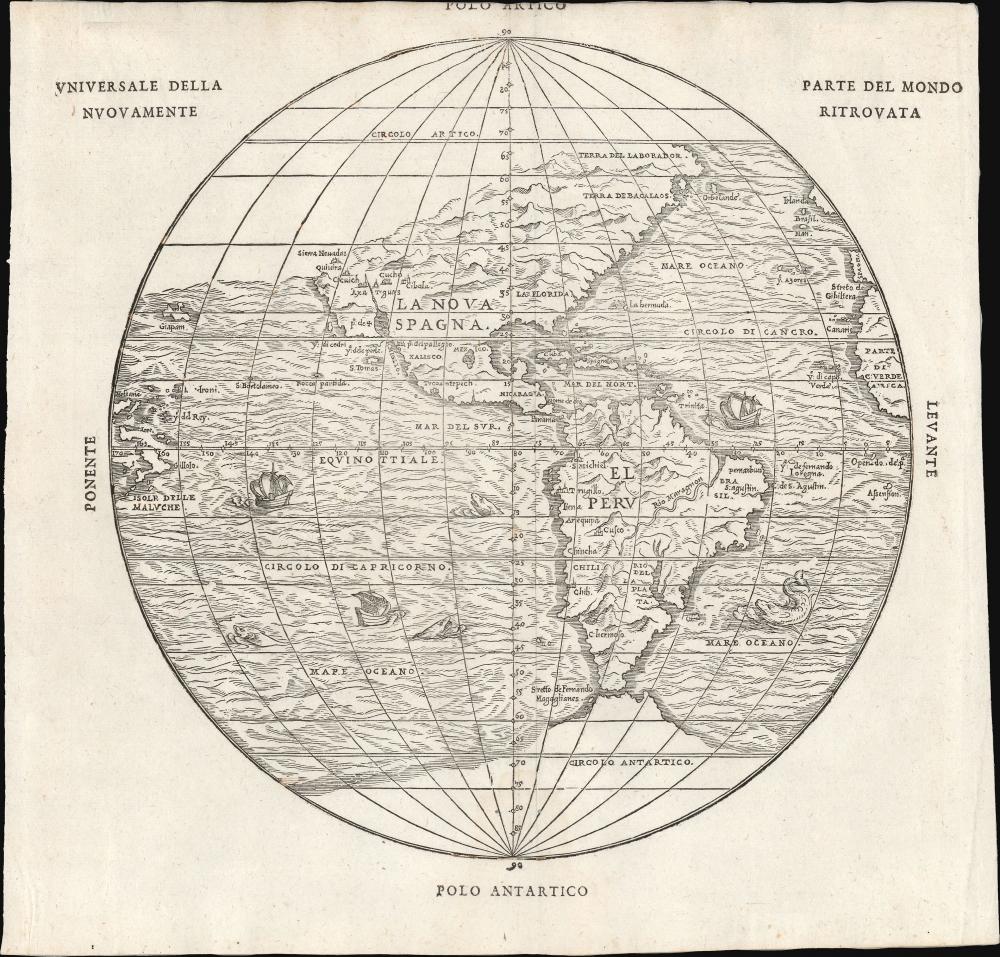
Universale Della Parte De Mondo Nuovamente Ritrovata.
1565 (undated) 11.5 x 11.75 in (29.21 x 29.845 cm) 1 : 75000000
1565 (undated) 11.5 x 11.75 in (29.21 x 29.845 cm) 1 : 75000000
Description
This is Giovanni Battista Ramusio's scarce 1565 map of the Americas. It first appeared in Ramusio's 1556 Navigationi et Viaggi, the first collection of explorers' first-hand accounts of their travels. It is among the earliest detailed representations of the Western Hemisphere, predated only by the 1540 Münster and the extremely rare 1554 Bellère map. This was the first printed map of America to include placenames from Coronado's travels of 1540-1542: Wheat hailed this inclusion as 'an advance of the first importance, so far as the mapping of the American West is concerned.'
Ramusio commissioned Giacomo Gastaldi (1500 - 1566) to compose this map, along with the others appearing in the Navigationi et Viaggi; that much of its detail agrees with the western portion of Gastaldi's 1546 world map supports this.
North of California, the map is less definitive. In Gastaldi's prior world maps, Asia and North America formed a contiguous land mass. By the 1560s, Gastaldi revised his cartography to separate the continents with a Strait of Anian. The present map may be the result of the cartographer's indecision: no American coastline appears north of California or Labrador.
Ramusio commissioned Giacomo Gastaldi (1500 - 1566) to compose this map, along with the others appearing in the Navigationi et Viaggi; that much of its detail agrees with the western portion of Gastaldi's 1546 world map supports this.
A Closer Look
The map presents the Americas spanning from the Strait of Magellan in the south to Labrador in the north. The Atlantic Ocean is depicted fully between the Arctic and Antarctic circles, including glimpses of the coasts of Ireland, Spain, and Africa. The Azores, Cape Verde Islands, and the Canary Islands appear, as does Bermuda. In the South Atlantic appear the Isla de Fernando de Noronha (hereI. de Fernando Lorogna) and an island named Openedo de. Pt.; to the south, the map names Assension, or Ascension Island. The Pacific Ocean is shown from just south of the Antarctic Circle to about 35 degrees north. The East Indies are shown in an embryonic form, naming the Moluccas, Gilolo, and the Ladrones. Japan appears to the north, with no Asian mainland in sight. To the south, the Strait of Magellan is depicted and named. Tierra del Fuego is shown with its coastline incomplete, suggesting a large landmass - although not the vast continent that would appear on Mercator's maps. South America is shown with superior detail than on the Münster; it does not supply as many of the placenames of the Bellère, but its physical presentation of the coastline is improved here. The Amazon, labeled here Rio Maragnon, is shown flowing from the southwest towards the northeast, agreeing with Gastaldi's world map. The woodcut, probably the work of Matteo Pagano, is beautifully executed, exhibiting hachured, pictorial mountains and oceans prowled by ships and monsters.North America and the Southwest
North America is much improved over either the Münster or the Bellère, despite its simplification. For example, the only placename associated with the Eastern part of what is now the United States is 'La Florida.' The western part of America bears significant new information: the place names drawn from Coronado's expeditions led Gastaldi to fully revise this geography. This would have come to him from Ramusio, who was the first to publish an account of Coronado's explorations with the result, as Burden notes, that 'this is the first printed American map to include any of the names from the travels of Francisco Vasquez de Coronado of 1540-42'. It is the first map to name the Sierra Nevada mountain range and to use the place name 'Quivira.' A stubby California is shown unambiguously as a peninsula. Central America, Mexico, and the Caribbean improve in detail upon the earlier Americas maps.North of California, the map is less definitive. In Gastaldi's prior world maps, Asia and North America formed a contiguous land mass. By the 1560s, Gastaldi revised his cartography to separate the continents with a Strait of Anian. The present map may be the result of the cartographer's indecision: no American coastline appears north of California or Labrador.
Publication History and Census
The first edition's woodcut was probably executed by Matteo Pagano for inclusion in the 1556 third volume of Ramusio's Navigationi et Viaggi. The woodblocks for this, and indeed all of the maps of the 1556 edition, burned in a 1557 warehouse fire. The blocks were all re-engraved, probably again by Pagano, for the 1565 edition of the Navigationi et Viaggi. The presently offered second block is geographically identical to the first. The two blocks are most easily distinguishable by differences in the placement of the title text: in 1556, the title appeared entirely in the upper left corner. This second block was used again 1606; that edition was easily identifiable by wormholing. The present example is of the 1606 edition, albeit with some of the 'wormholes' filled in manuscript. This work is rare. Seven examples of the 1565 Navigationi et Viaggi are listed in OCLC. Twenty of the 1606 editions appear. There are only 9 separate OCLC citations for this 1606 separate map.CartographerS
Giovanni Battista Ramusio (July 20, 1485 - July 10, 1557) was an Italian civil servant, humanist, scholar, historian, and geographer active in the middle part of the 16th century. Ramusio spent most of his life in the service of the Republic of Venice, first as part of that state's embassy to France, and later as a reporter on voyages and discoveries. He was born to an illustrious family in Treviso and moved to Vencie as a young man, where his father was a magistrate. He studied at the University of Padua but may not have received a full degree. He entered the civil service shortly after leaving the university and was immediately assigned to diplomatic service for his facility with languages, particularly French. His most significant contribution to cartography is his publication of Navigationi et Viaggi a collection of travel narratives he collected in his service to the state. The narratives include those of Marco Polo, Niccolò Da Conti, Magellan, Alvar Nuñez Cabeza de Vaca, Giosafat Barbaro, and Tomé Pires, among others. Some of the voyages appearing in the Navigationi et Viaggi are otherwise unknown, marking it as an exceptionally important volume. Ramusio died in Venice in 1557. More by this mapmaker...
Giacomo Gastaldi (c. 1500 - October, 1566) was an Italian astronomer, cartographer, and engineer active in the second half of the 16th century. Gastaldi (sometimes referred to as Jacopo or Iacobo) began his career as an engineer, serving the Venetian Republic in that capacity until the fourth decade of the sixteenth century. During this time he traveled extensively, building a large library relating to voyages and exploration. From about 1544 he turned his attention to mapmaking, working extensively with Gextantiovanni Battista Ramusio, Nicolo Bascarini, and Giovanbattista Pedrezano, as well as taking private commissions for, among others, Venice's Council of Ten. He is credited with the fresco maps of Asia and Africa still extant in the map room of the Doge's Palace. Gastaldi was also one of the first cartographers to embrace copper plate over woodblock engraving, marking an important development in the history of cartography. His 1548 edition of Ptolemy's Geographia was the first to be printed in a vernacular; it was the first to be printed in copperplate. As with his Swiss/German contemporary Münster, Gastaldi's work contained many maps depicting newly discovered regions for the first time, including the first map to focus on the East Coast of North America, and the first modern map of the Indian Peninsula. His works provided the source for the vast majority of the Venetian and Roman map publishers of the 1560s and 70s, and would continue to provide an outsize influence on the early maps of Ortelius, De Jode, and Mercator. Learn More...
Matteo Pagano (1515-1588) was a Venetian woodcut artist and illustrator. While nothing is known about his early training, he was prolific and apparently successful. Among his more famous works is a 1556 eight-sheet woodcut of the procession of the Doge, in Venice. He produced a number of maps for various works, most notably the visually distinctive area maps appearing in Ramusio's Navigazioni et Viaggi. He is particularly noted for having published books of lace, needlework and embroidery designs, promoting needlework as an acceptable activity for virtuous women. Learn More...
Source
Ramusio, G. B., Delle Navigationi et Viaggi Raccolte da M. Gio. Battista Ramusio, (Venice: Appresso i Giunti) 1606.
Condition
Very good. Sheet trimmed at top, just entering text. No print loss, but manuscript infill in a few areas. Else excellent with a bold strike.
References
OCLC 218032300. Burden, P., The Mapping of North America, #24. Wheat, Carl Irving, Mapping the Transmississippi West, 1540-1861, v. 1, no. 9.