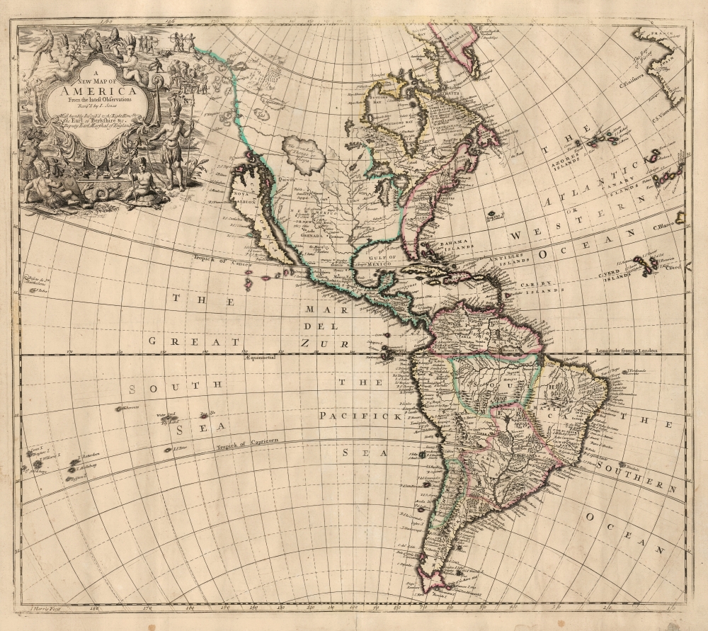
This elegant English map of the Western Hemisphere, produced by John Senex in 1721, presents a fascinating glimpse of early Colonial America - increasingly detailed in the east, whilst retaining great misconceptions with regard to the western part of the continent.
A Closer Look
This large, attractively engraved work presents the Americas centrally, spanning as far west as the Cocos Islands in the Pacific, and the coasts of France and Spain in the east; glimpses of Africa can be seen in Capo Blanco and Cape Verde. The map reaches from Tierra del Fuego in the south, to Greenland and Baffin's Bay in the north. The cartouche in the upper left is framed with portrayals of Native Americans, together with snakes, turtles, and parrots. In the background, indigenous warriors fight. Nearby is a cannibal scene derived from the long-lived imagery first appearing in De Bry's 16th-century compilation of voyage accounts.) Among the prominent features of North America are its well-realized Great Lakes. The Mississippi, roughly following Hennepin, empties into the Gulf of Mexico in the vicinity of Galveston Bay. An expansive, enigmatic lake dominates the Pacific Northwest. This lake predates by more than 30 years the French 'Sea of the West' apocrypha. California is presented as an island after the Sanson model. In the southeast, Florida is bisected by a unique, unnamed river flowing from the vicinity of Virginia.Insular California
Senex preserves one of the most tenacious 17th-century cartographic tropes: the island of California. The concept of an insular California first appeared as a work of fiction in Garci Rodriguez de Montalvo's c. 1510 romance Las Sergas de Esplandian, but the mythical island would not be detailed in a map until the English 1625 Briggs map of North America. The notion dominated 17th-century maps of the Americas, persevering even after Eusebio Kino's 1705 map proved the falsity of the idea.
One distinct difference between Senex's Pacific Coast and its Dutch precursors is its depiction of the coast north of California. By the end of the 17th century, most mapmakers simply omitted this coastline, encouraging hopes that the Pacific might communicate easily with the Atlantic via Hudson's Bay or some more northerly Northwest Passage. Senex's map includes (and names) several conjectural islands and portrays three large lakes dominating the northwest: L. Aquinanbock, L. of Isles, and a huge lake labeled The Great Lake of Thongo or Thoya. All are spurious, but Thongo or Thoya seems to be a precursor to the equally vaporous Sea of the West, which dominated French maps of the later 18th century.Publication History and Census
The map is cartographically derived from Peter Heylyn's 1703 Cosmography. Although McLaughlin dates this map to 1719, it first appears in Senex's 1721 New General Atlas. It was engraved by John Harris. A handful of examples of the separate map appear in institutional collections.
CartographerS
John Senex (1678 - 1740) was an English engraver and map maker active in London during the first half of the 18th century. Senex was born to upper middle class parents in Shropshire, England. As a young man, he was apprenticed to Robert Clavell, a London bookseller and member of the Stationers' Company, under whom he mastered the arts of engraving and printmaking. Around 1702 Senex completed his apprenticeship and established himself as a printer and bookseller in the Strand. A year later Senex partnered with Jeremiah Seller and Charles Price, the successors to the important mapmaker John Seller, and relocated to Cornhill. This was likely Senex's first introduction to mapmaking though he seems to have taken to it with abandon. In the subsequent years Senex established himself as one of the most prominent cartographers in London, publishing a number of beautiful and important maps that today rank among the finest examples from the Golden Age of British Cartography. In addition to a large corpus of flat maps, Senex also produced a number of important and highly desirable globes. Eventually Senex dissolved his partnership with Seller and Price and relocated to Fleet Street, where he maintained offices until his death in 1740. Senex was succeeded by his widow, Mary Senex, who continued to publish and update his works until about 1755, when the remaining globe and map plates were sold to James Ferguson. More by this mapmaker...
John Harris (fl. 1686 – 1730) was a British cartographer, engraver and draughtsman active in London during the late 17th and early 18th centuries. Harris is believed to have been born in Northamponshire but little else is certain regarding his personal life as 'John Harris' was an exceedingly common name be 17th century London. Nonetheless, his known work includes engravings for Philip Lea, Robert Morden, Herman Moll, and others. Learn More...
Source
Senex, J., A new general atlas, (London: Browne) 1721.
Very good. Mounted on old linen. Few areas of scuffing with minimal loss. Original outline color.
Tooley, R. V., The Mapping of America, Chapter 3, #81. McLaughlin, G., The Mapping of California as an Island, #193. Not in McGuirk.