Digital Image: 1799 George Thompson Map of North America and South America
America-thompson-1799_d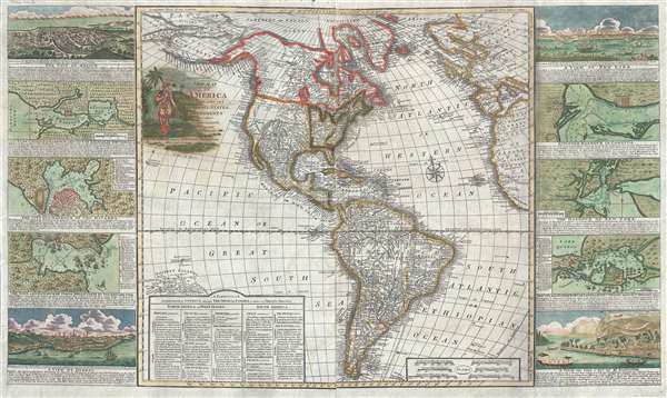

Title
New Map of America divided into its Kingdoms, States, Governments and other Subdivisions, from the latest observations.
1799 (dated) 22 x 37.5 in (55.88 x 95.25 cm) 1 : 25500000
1799 (dated) 22 x 37.5 in (55.88 x 95.25 cm) 1 : 25500000
Description
FOR THE ORIGINAL ANTIQUE MAP, WITH HISTORICAL ANALYSIS, CLICK HERE.
Digital Map Information
Geographicus maintains an archive of high-resolution rare map scans. We scan our maps at 300 DPI or higher, with newer images being 600 DPI, (either TIFF or JPEG, depending on when the scan was done) which is most cases in suitable for enlargement and printing.
Delivery
Once you purchase our digital scan service, you will receive a download link via email - usually within seconds. Digital orders are delivered as ZIP files, an industry standard file compression protocol that any computer should be able to unpack. Some of our files are very large, and can take some time to download. Most files are saved into your computer's 'Downloads' folder. All delivery is electronic. No physical product is shipped.
Credit and Scope of Use
You can use your digial image any way you want! Our digital images are unrestricted by copyright and can be used, modified, and published freely. The textual description that accompanies the original antique map is not included in the sale of digital images and remains protected by copyright. That said, we put significant care and effort into scanning and editing these maps, and we’d appreciate a credit when possible. Should you wish to credit us, please use the following credit line:
Courtesy of Geographicus Rare Antique Maps (http://www.geographicus.com).
How Large Can I Print?
In general, at 300 DPI, you should at least be able to double the size of the actual image, more so with our 600 DPI images. So, if the original was 10 x 12 inches, you can print at 20 x 24 inches, without quality loss. If your display requirements can accommodate some loss in image quality, you can make it even larger. That being said, no quality of scan will allow you to blow up at 10 x 12 inch map to wall size without significant quality loss. For more information, it is best consult a printer or reprographics specialist.
Refunds
If the high resolution image you ordered is unavailable, we will fully refund your purchase. Otherwise, digital images scans are a service, not a tangible product, and cannot be returned or refunded once the download link is used.
Cartographer
George Thompson (June 17, 1758 – February 15, 1826) was a British stationer, printer, and map publisher active in London in the late 18th and early 19th century. Thompson was born in London, the son of a butcher. He apprenticed with William Morgan of the Stationers Guild in 1773. Thompson produced few maps, all of which were separately issued broadsides. Around 1798 – 1799 he appears to have issued a series of large format broadside map of the world and continents. All George Thompson maps are extremely rare today. Thompson was succeeded by his son, George Nathaniel Thompson, after his death in 1834. Although Thompson published few maps, the size of his fortune at death, nearly 70,000 GPB suggests that he was a highly successful printer and stationer. More by this mapmaker...
References
OCLC 84675541 (1813 edition).