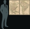
1851 / 1849 Dufour Map Pair of North America and South America
Americas-dufour-1851$3,500.00


Title
Amérique du Nord. / Amérique du Sud.
1851 (dated) 37 x 26 in (93.98 x 66.04 cm) 1 : 10256000
1851 (dated) 37 x 26 in (93.98 x 66.04 cm) 1 : 10256000
Description
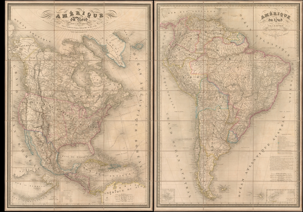
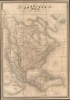
This is a beautiful 1851 pair of A. H. Dufour large-format folding maps of North America and South America, presented together in an original slipcase. The North America map captures an ephemeral look at the Transmississippi in the year after the Treaty of Guadalupe Hidalgo - including a most unusual mapping of the borders of Texas.The South America map shows the political divisions just prior to the Platine War, between the Empire of Brazil and the Argentine Confederation.
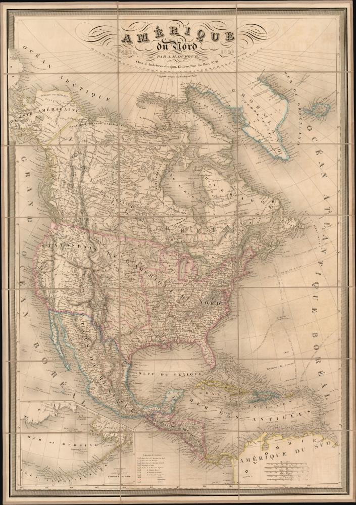
Lands to the west, including California, remain in the vast, largely uncharted block acquired by the United States at the end of the Mexican-American War (1846 - 1848). Sutter's gold-producing colony of New Helvetica, identified on the 1849 issue of this map, has been changed to Sacramento. Further north, Oregon is named more prominently than on the earlier issue. Changes appear in the United States' interior as well. Here, Iowa City has been renamed 'Monroe.' Some placenames, such as 'Memphis,' have been been updated with more legible typography.
The map includes the defunct' Colonie Russe' just north of San Francisco, which stopped functioning as a Russian colony in 1841 and by 1849 was acquired by John Sutter.
Between Oregon and the Missouri River, lands are divided into the Mandan, Osage, and Ozark Districts. Although somewhat overlapping and indistinct, these were temporary designations for vast territories occupied by a host of American Indian tribes, as well as tribes relocated there after 1830. Here we can see that many of the districts overlap, not only with one another, but also with newly created encroaching states. The Mandan District is co-labeled 'Nebraska', this being one of the first instances we have identified of the term being used to refer to this region, which, in just 3 years, would be incorporated as Nebraska Territory.
An inset in the lower left details the Bering Sea and the Aleutian Islands.
A Closer Look: North America
The map covers North America and Greenland, embracing the United States, a newly integrated Texas, Mexico, Canada, Central America, and the Caribbean. Texas extends west nearly to Santa Fe. This unusual configuration is likely inherited from the old borders of the Republic of Texas - which the French were the first to formally recognize. It does not recognize the expansive borders claimed by Texas post-annexation, likely a result of the ambiguity of the post-treaty era. The Comprimise of 1850 is not recognized.Lands to the west, including California, remain in the vast, largely uncharted block acquired by the United States at the end of the Mexican-American War (1846 - 1848). Sutter's gold-producing colony of New Helvetica, identified on the 1849 issue of this map, has been changed to Sacramento. Further north, Oregon is named more prominently than on the earlier issue. Changes appear in the United States' interior as well. Here, Iowa City has been renamed 'Monroe.' Some placenames, such as 'Memphis,' have been been updated with more legible typography.
The map includes the defunct' Colonie Russe' just north of San Francisco, which stopped functioning as a Russian colony in 1841 and by 1849 was acquired by John Sutter.
Between Oregon and the Missouri River, lands are divided into the Mandan, Osage, and Ozark Districts. Although somewhat overlapping and indistinct, these were temporary designations for vast territories occupied by a host of American Indian tribes, as well as tribes relocated there after 1830. Here we can see that many of the districts overlap, not only with one another, but also with newly created encroaching states. The Mandan District is co-labeled 'Nebraska', this being one of the first instances we have identified of the term being used to refer to this region, which, in just 3 years, would be incorporated as Nebraska Territory.
An inset in the lower left details the Bering Sea and the Aleutian Islands.
Texas Borders
The borders of the Republic of Texas were in dispute from the earliest days of the Texan Revolution. The Republic-claimed borders followed the Treaties of Velasco between the newly created Texas Republic and Mexican leader, Antonio López de Santa Anna. The treaties established an eastern boundary following the 1819 Adams-Onís Treaty between the United States and Spain, which established the Sabine River as the eastern boundary of Spanish Texas and western boundary of the Missouri Territory. The Republic's southern and western boundary with Mexico was more nuanced. Texas claimed the Rio Grande del Norte as its western and southernmost border, while Mexico argued for a boundary much further east at the Nueces River. When Texas was annexed into the United States, the agreement followed the Republic-claimed boundary, thus absorbing Mexican-claimed territory as far west as Santa Fe. This escalated already existing tensions between the United States, the former Republic of Texas, and Mexico, ultimately triggering for the Mexican-American War (1846 - 1848).A Closer Look: South America
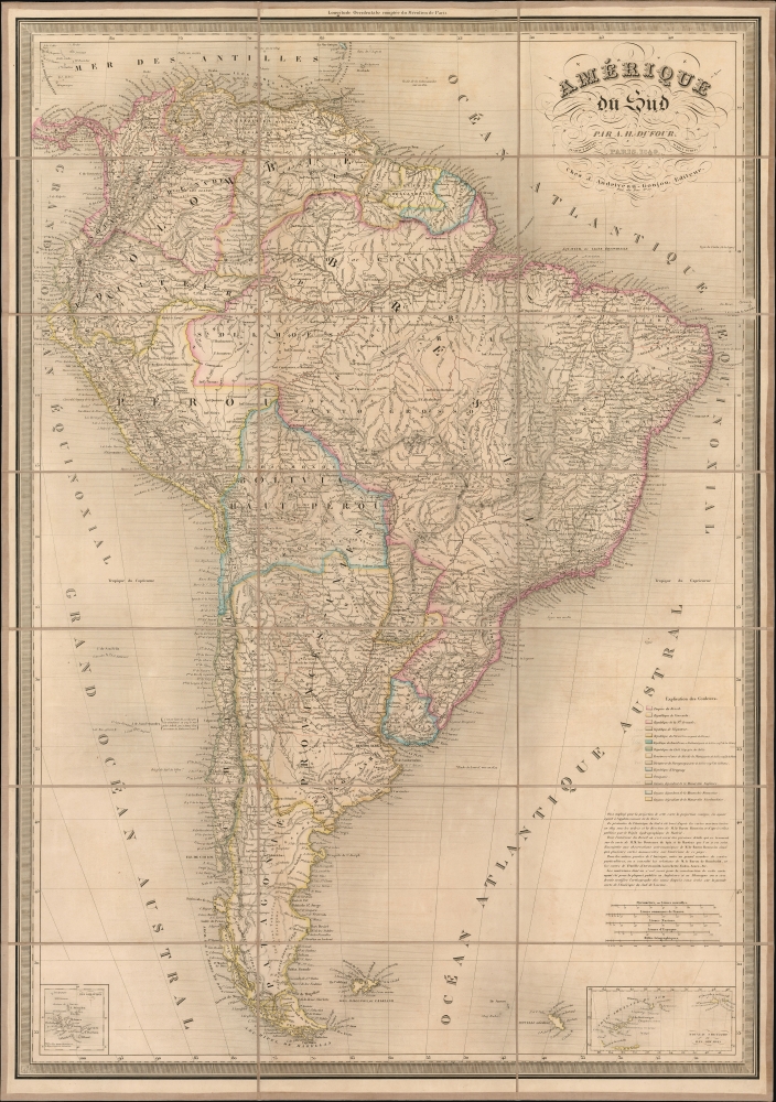
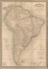
Dufour's Amérique du Sud appears here in its 1849 edition. (In 1851, this was the most current edition of the map, which was next revised in 1856.) The map presents the southern part of the continent in the extended period of turmoil following the wave of South American independence movements, with the central and eastern areas dominated by the United Provinces and Empire of Brazil. The border between these powers in the Missiones Region is indicated along the Uruguay River (as per the Cisplatine War of the 1820s.) The northern border of Paraguay with Brazil reaches the River Mboymboy, well short of Albuquerque and the Tacuary River. Uruguay is shown with its Brazilian border south of Lake Mirim, again reflective of the borders following the Cisplatine War (1825 - 1828). In the north, although it shows subdivisions including Ecuador and Venezuela, all part of the collapsing Gran Colombia. The region now generally associated with that name is labeled New Grenada. In the lower left and right corners are inset maps detailing the Galapagos Islands and the South Shetland Islands, respectively.Publication History and Census
These maps were initially engraved for separate publication in 1836 by Jean Andriveau-Goujon. They were drawn by Adolphe Hippolyte Dufour (1795 - 1865), also known as Auguste-Henri Dufour, and engraved by Jacques-Michel Flahaut. The typography is credited to Warin, who remains elusive. There are examples of the North America map dated as early as 1834 and as late as 1887. The map was not updated between 1836 and 1848 (per Rumsey), but the 1849 issue exhibited significant updates and revisions, and this 1851 issue contains further changes. These were issued both in the Andriveau-Goujon / Dufour Atlas de Choix, ou Recueil des Meilleures Cartes de Geographie Ancienne et Moderne Dressees par Divers Auteurs, and separately as dissected folding maps, as here. While the atlas and the individual maps in it are not rare in late editions, we see only two separate examples of the 1851 North America in OCLC, and five of the 1849 South America.CartographerS
Adolphe Hippolyte Dufour (1795 - 1865), also known as Auguste-Henri Dufour, was a Paris based map and atlas publisher active in the middle to late 19th century. Dufour claimed to be a student of another French cartographer, Emile Lapie. He is known to have worked with numerous other French cartographers, publishers, and engravers of the period including Andriveau-Goujon, Charles Dyonnet, and Duvotenay. His corpus includes numerous maps and atlases, the most striking of which is probably his monumental elephant folio Atlas Universel Physique, Historique et Politique Geographie Ancienne et Moderne. Dufour's student and successor was Alexandre Vuillemin. More by this mapmaker...
Eugène Andriveau-Goujon (1832 - 1897) was a map publisher and cartographer active in 19th century Paris. The firm was created in 1825 when Eugène Andriveau married the daughter of map publisher Jean Goujon - thus creating Andriveau-Goujon. Maps by Andriveau-Goujon are often confusing to identify as they can be alternately singed J. Goujon, J. Andriveau, J. Andriveau-Goujon, E. Andriveau-Goujon, or simply Andriveau-Goujon. This refers to the multiple generations of the Andriveau-Goujon dynasty and the tendency to republish older material without updating the imprint. The earliest maps to have the Andriveau-Goujon imprint were released by Jean Andriveau-Goujon. He passed the business to his son Gilbert-Gabriel Andriveau-Goujon, who in 1858 passed to his son, Eugène Andriveau-Goujon, under whose management the firm was most prolific. Andriveau-Goujon published numerous fine pocket maps and atlases throughout the 19th century and often worked with other prominent French cartographers of the time such as Brue and Levasseur. The firm's stock was acquired by M. Barrère in 1892. Learn More...
Jacques-Michel Flahaut (1791 - March 20, 1864) was a Paris-based French engraver active in the middle part of the 19th century. Flauhat was born in Paris and worked extensively in Paris mapmaking communities. He engraved for Pierre M. Lapie (fl. 1779 - 1850) and his son Alexandre Emile Lapie (fl. 1809 - 1850), as well as for Adolphe Hippolyte Dufour (1795 - 1865), and Jean Andriveau-Goujon. He was based at 9 Rue de L'est. Learn More...
Condition
Excellent. Dissected and mounted on linen for folding, with original marbled paper slipcase. Original wash color.
References
Rumsey 12050.060 (1852 edition,) 12050.065.