Digital Image: 1890 Burleigh / Norris Bird's-Eye View of Amesbury, Massachusetts
Amesbury-burleighnorris-1890_d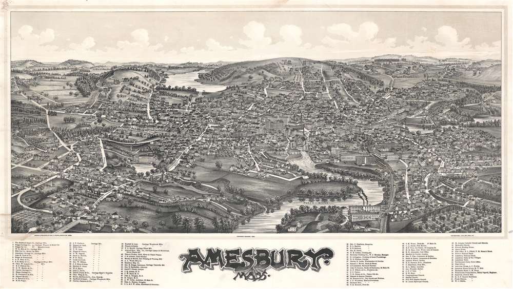

Title
Amesbury, Mass.
1890 (dated) 19 x 33.5 in (48.26 x 85.09 cm)
1890 (dated) 19 x 33.5 in (48.26 x 85.09 cm)
Description
FOR THE ORIGINAL ANTIQUE MAP, WITH HISTORICAL ANALYSIS, CLICK HERE.
Digital Map Information
Geographicus maintains an archive of high-resolution rare map scans. We scan our maps at 300 DPI or higher, with newer images being 600 DPI, (either TIFF or JPEG, depending on when the scan was done) which is most cases in suitable for enlargement and printing.
Delivery
Once you purchase our digital scan service, you will receive a download link via email - usually within seconds. Digital orders are delivered as ZIP files, an industry standard file compression protocol that any computer should be able to unpack. Some of our files are very large, and can take some time to download. Most files are saved into your computer's 'Downloads' folder. All delivery is electronic. No physical product is shipped.
Credit and Scope of Use
You can use your digial image any way you want! Our digital images are unrestricted by copyright and can be used, modified, and published freely. The textual description that accompanies the original antique map is not included in the sale of digital images and remains protected by copyright. That said, we put significant care and effort into scanning and editing these maps, and we’d appreciate a credit when possible. Should you wish to credit us, please use the following credit line:
Courtesy of Geographicus Rare Antique Maps (http://www.geographicus.com).
How Large Can I Print?
In general, at 300 DPI, you should at least be able to double the size of the actual image, more so with our 600 DPI images. So, if the original was 10 x 12 inches, you can print at 20 x 24 inches, without quality loss. If your display requirements can accommodate some loss in image quality, you can make it even larger. That being said, no quality of scan will allow you to blow up at 10 x 12 inch map to wall size without significant quality loss. For more information, it is best consult a printer or reprographics specialist.
Refunds
If the high resolution image you ordered is unavailable, we will fully refund your purchase. Otherwise, digital images scans are a service, not a tangible product, and cannot be returned or refunded once the download link is used.
Cartographer S
George E. Norris (1855 – 1926) was an American hotelier, publisher, and bird's-eye view artist based in Brockton, Massachusetts during the latter part of the 19th century. Norris began publishing views in partnership with Albert F. Poole, an established view maker who, at the time, was renting a house in Brockton from Norris' mother. His first views, most of which were signed by Poole, were published in 1883. In 1884 Norris partnered with Henry Wellge, publishing out of Brockton as Norris and Wellge, and later out of Milwaukee as Norris, Wellge and Co. Norris began drawing views independently around 1887. Most of these were printed by Lucien Burleigh of Troy New York. In total, Norris produced about 135 individual city views. In 1897 he left the view business to open a hotel, the Hotel Norris, in Brockton. Meeting some success in this field, in acquired the Hotel Grayson, also in Brockton, in 1912. He ran this until his death of cerebral hemorrhage in 1926. More by this mapmaker...
Lucian Rinaldo Burleigh (February 6, 1853 – July 30, 1923) was an American lithographer and view maker active in the latter part of the 19th century. Burleigh was born in Plainfield, Connecticut and studied civil engineering at Worcester County Free Institute of Industrial Science (Worcester Polytechnic). There he studied under George E. Gladwin who specialized in field sketching. Burleigh became one of Gladwin's prized students and this no doubt influenced his choice to become a viewmaker. Burleigh's view work stands out for two reasons. One, most of his town views are drawn form a lower than usual point of view enabling him to take greater advantage of profile perspectives. Two, his views do not integrate people or animals – most late 19th century American view artists added horses, people, carts, dogs, and even chickens to their views. Between the years of 1883 and 1885 Burleigh produced some 28 views of New York towns and cities. Most of these were published by either Beck and Pauli of Milwaukee or C. H. Voght of Cleveland. After 1886, Burleigh established his own Troy press and subsequent views were published in-house. Burleigh also worked as a lithographer for other view makers including J. J. Stoner and Albert Ruger, among many others. Burleigh contributed to the production of about 228 lithographic city views and personally drew about 120, marking him one of the most important and influential viewmakers of the 19th century. Learn More...
References
Library of Congress, G3764.A4A3 1890.N6. Reps, John, Views and Viewmakers of Urban America (University of Missouri, Columbia, 1984), #1333.