This item has been sold, but you can get on the Waitlist to be notified if another example becomes available, or purchase a digital scan.
1886 Burleigh Bird's-eye View Map of Amherst, Massachusetts
Amherst-burleigh-1886$925.00

Title
Amherst, Mass. 1886.
1886 (dated) 17 x 38.5 in (43.18 x 97.79 cm)
1886 (dated) 17 x 38.5 in (43.18 x 97.79 cm)
Description
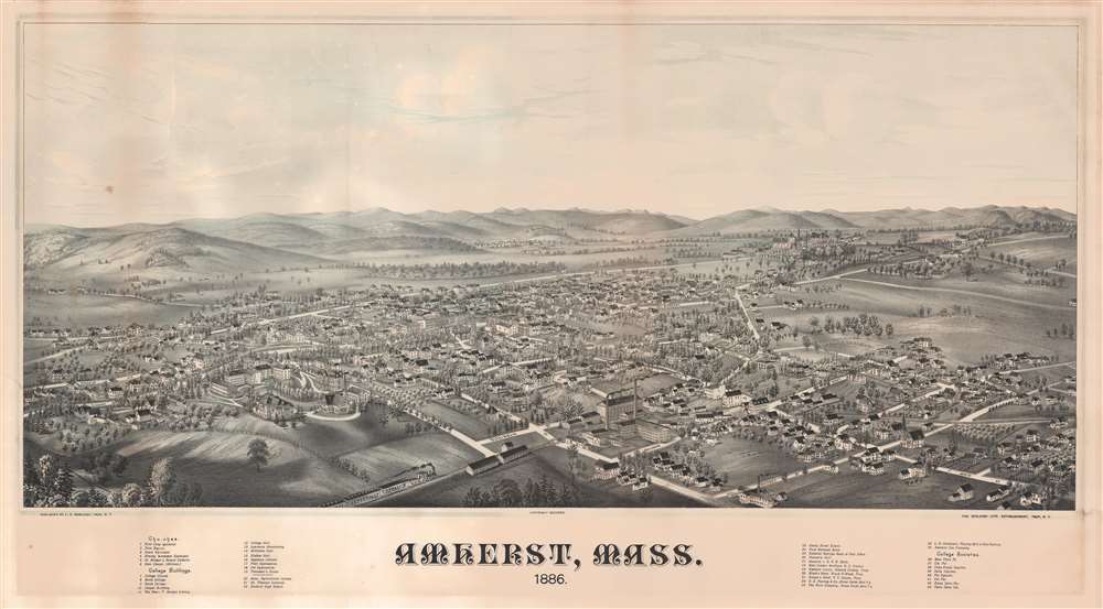
A rare 1886 two-color chromolithograph bird's-eye view map of Amherst, Massachusetts by the prominent viewmaker Lucien Rinaldo Burleigh. The view looks on Amherst from a fictional highpoint to the southwest, roughly over the modern-day campus of Amherst College. The Massachusetts Agricultural College (UMass Amherst) is also noted. In the town itself all streets are labeled, and some 43 buildings are numerically keyed to a table in the lower margins. In the foreground, the New London and Northern Railroad steams past two large basketry mills towards Amherst Station. The hills of the Holyoke Range roll off into the distance, in all conveying the image of a prosperous college town with a growing industrial base.
City views were being produced in the United States as early as the 1830s, but the genre exploded after the American Civil War (1861 - 1865). Bridging the gap between maps and pictures, most 19th century American Bird's-eye views presented cities to the public high vantage points. Some were imagined, but others were drawn from hot-air balloons or nearby hills. The presentation, combining high elevation, commercial interest, and new printing technology created a uniquely American art form, as described by historian Donald Karshan,
Amherst City
Amherst, located at the eastern edge of the Pioneer Valley, Central Massachusetts, was settled in 1703 and incorporated as Amherst in 1759. The town was named after Baron Jeffery Amherst (1717 - 1797), a British nobleman and military officer who led British forces during the French and Indian War (1754 - 1763), but who was rumored to be a colonial sympathizer during the subsequent American Revolutionary War (1775 - 1783). Amherst was a sleepy farming town until the early 19th century, when the founding of Amherst College (1821) and the arrival of the railroad (1853) began to spur settlement and growth. When this view was made, Amherst had a population of roughly 4500. Today, ten times as many people call it home.Amherst College
In the mid-ground no fewer that 14 buildings on the already-sprawling Amherst College Campus (est. 1821) are identified. Amherst College was founded in 1821 by Zephaniah Swift Moore who attempted to relocate Williams College - which was then struggling due to its remote location. Although Williams never relocated, Amherst College was an immediate success and grew quickly. By the 1830s it was second only to Yale for size. Today, Amherst is considered among the most selective American undergraduate colleges with a distinguished alumni record that includes Calvin Coolidge (30th US President), Prince Albert II of Monaco, and Uhuru Kenyatta (President of Kenya).American Bird's-Eye City Views
The tradition of the bird's-eye city view emerged in the United States in the middle part of the 19th century and coincided with the commercial development of lithographic printing. While before the rise of lithography, the ability to own and display artwork in the home was largely limited to the extremely wealthy, lithographic printing made it possible for everyone to own visually striking artwork. A robust trade developed in portraits of political leaders, allegorical and religious images, and city views.City views were being produced in the United States as early as the 1830s, but the genre exploded after the American Civil War (1861 - 1865). Bridging the gap between maps and pictures, most 19th century American Bird's-eye views presented cities to the public high vantage points. Some were imagined, but others were drawn from hot-air balloons or nearby hills. The presentation, combining high elevation, commercial interest, and new printing technology created a uniquely American art form, as described by historian Donald Karshan,
Some print connoisseurs believe that it was only with the advent of the full-blown city-view lithograph that American printmaking reached its first plateau of originality, making a historical contribution to the graphic arts. They cite the differences between the European city-view prints and the expansive American version that reflects a new land and a new attitude toward the land.The vogue for bird's-eye city views lasted from about 1845 to 1920, during which period some 2,400 cities were thus portrayed, some multiple times. Although views were produced in many urban centers, the nexus of view production in the United States was Milwaukee, Wisconsin. The major American viewmakers were Stoner, Wellge, Bailey, Fowler, Hill, Ruger, Koch, Burleigh, Norris, and Morse, among others.
Chromolithography
Chromolithography is a color lithographic technique developed in the mid-19th century. The process involved using multiple lithographic stones, one for each color, to yield a rich composite effect. Oftentimes, the process would start with a black basecoat upon which subsequent colors were layered. Some chromolithographs used 30 or more separate lithographic stones to achieve the desired product. Chromolithograph color could also be effectively blended for even more dramatic results. The process became extremely popular in the late 19th and early 20th centuries, when it emerged as the dominate method of color printing. The vivid color chromolithography produced made it exceptionally effective for advertising and propaganda imagery.Publication History and Census
This view was drawn and published by Lucien Rinaldo Burleigh from his offices in Troy, New York in 1886. Examples are scarce. We note one at the Boston Public Library and two at the Library of Congress.Cartographer
Lucian Rinaldo Burleigh (February 6, 1853 – July 30, 1923) was an American lithographer and view maker active in the latter part of the 19th century. Burleigh was born in Plainfield, Connecticut and studied civil engineering at Worcester County Free Institute of Industrial Science (Worcester Polytechnic). There he studied under George E. Gladwin who specialized in field sketching. Burleigh became one of Gladwin's prized students and this no doubt influenced his choice to become a viewmaker. Burleigh's view work stands out for two reasons. One, most of his town views are drawn form a lower than usual point of view enabling him to take greater advantage of profile perspectives. Two, his views do not integrate people or animals – most late 19th century American view artists added horses, people, carts, dogs, and even chickens to their views. Between the years of 1883 and 1885 Burleigh produced some 28 views of New York towns and cities. Most of these were published by either Beck and Pauli of Milwaukee or C. H. Voght of Cleveland. After 1886, Burleigh established his own Troy press and subsequent views were published in-house. Burleigh also worked as a lithographer for other view makers including J. J. Stoner and Albert Ruger, among many others. Burleigh contributed to the production of about 228 lithographic city views and personally drew about 120, marking him one of the most important and influential viewmakers of the 19th century. More by this mapmaker...
Condition
Good. Some mat burn and toning. A minor water stain evident at left and right margins. There is a large cleanly repaired closed tear form the top margin, left side, extending about 5 inches into the image.
References
Library of Congress Panoramic maps (2nd ed.), #266. Library of Congress, G3764.A49A3 1886 .B8. Reps, John, Views and Viewmakers of Urban America (University of Missouri, Columbia, 1984), #1336.