This copy is copyright protected.
Copyright © 2025 Geographicus Rare Antique Maps
Digital Image: 1880 L. W. Kip First Missionary Map of Xiamen (Amoy), Fujian, China
AmoyXiamenMissionary-kip-1880_d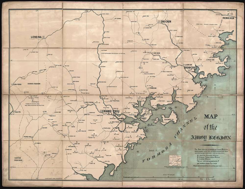

FOR THE ORIGINAL ANTIQUE MAP, WITH HISTORICAL ANALYSIS, CLICK HERE.
Digital Map Information
Geographicus maintains an archive of high-resolution rare map scans. We scan our maps at 300 DPI or higher, with newer images being 600 DPI, (either TIFF or JPEG, depending on when the scan was done) which is most cases in suitable for enlargement and printing.
Delivery
Once you purchase our digital scan service, you will receive a download link via email - usually within seconds. Digital orders are delivered as ZIP files, an industry standard file compression protocol that any computer should be able to unpack. Some of our files are very large, and can take some time to download. Most files are saved into your computer's 'Downloads' folder. All delivery is electronic. No physical product is shipped.
Credit and Scope of Use
You can use your digial image any way you want! Our digital images are unrestricted by copyright and can be used, modified, and published freely. The textual description that accompanies the original antique map is not included in the sale of digital images and remains protected by copyright. That said, we put significant care and effort into scanning and editing these maps, and we’d appreciate a credit when possible. Should you wish to credit us, please use the following credit line:
Courtesy of Geographicus Rare Antique Maps (http://www.geographicus.com).
How Large Can I Print?
In general, at 300 DPI, you should at least be able to double the size of the actual image, more so with our 600 DPI images. So, if the original was 10 x 12 inches, you can print at 20 x 24 inches, without quality loss. If your display requirements can accommodate some loss in image quality, you can make it even larger. That being said, no quality of scan will allow you to blow up at 10 x 12 inch map to wall size without significant quality loss. For more information, it is best consult a printer or reprographics specialist.
Refunds
If the high resolution image you ordered is unavailable, we will fully refund your purchase. Otherwise, digital images scans are a service, not a tangible product, and cannot be returned or refunded once the download link is used.
Leonard W. Kip (November 10, 1837 - February 27, 1901) was an American missionary active in China during the second half of the 19th century. Kip was born in New York City to a wealthy family, but nonetheless, joined the China Board in his religious devotion. Kip first traveled to China in 1861 with the Chinese Mission of the American Reformed Church and established himself at the Amoy (Xiamen) mission. Kip was extremely zealous in parenthesizing the Christian Gospel and traveled extensively through the region. With is educational background, and extensive travels, Kip became the unofficial geographer of the mission, compiling the first accurate western style map of the Xiamen region. He remained with the mission until 1899, at which point, in ill health he returned to the United States, dying 2 years later, in 1901. There are some, apparently erroneous, reports that he may have died in Xiamen, China. More by this mapmaker...
George Whitefield Hatch (1805 - 1867) was an American lithographer, viewmaker, and portraitist, based in New York. Hatch was born in Johnstown, New York, the son of George Whitefield Hatch Sr. (1770 - 1829). He moved to New York city in the Mid 1820s to study engraving and painting under Asher Brown Durand (1796 - 1886). He then moved to Albany, where he was active as an engraver as early as 1831, when he issued works with James Smillie under the imprint of 'Hatch and Smillie'. In 1832, he returned to New York to become a partner in the banknote engraving firm of Rawdon, Wright, and Hatch. Banknote work led him to become a founding partner in the American Banknote Company, of which he was president between 1863 and 1866. In 1853, he partnered with Charles Severyn (1820 - 18??) to found 'Hatch and Severyn,' a new firm specializing in chromolithography. When Hatch's son George Whitefield Hatch Jr. (1830 - 1856) and his younger brother Warner Daniels Hatch (1831 - 1884) joined the firm shortly afterwards, the imprint was revised to 'Hatch and Co.' George Whitefield Hatch Jr. died in 1856, at just 26, Warner Daniels Hatch became a full partner. When George Whitefield Hatch Sr. died in 1867, Warner Daniels Hatch took on full management. The company reorganized in 1872 as the 'Hatch Lithographic Company'. On July 18, 1884, The New York Sun News reported that Warner D. Hatch drowned under mysterious circumstances, possibly suicide. While active the Hatch firm specialized in chromolithography, certificates, trade cards, and advertising. Management fell to Warner Hatch Nostrand, who ran the company until 1889, when it was dissolved under insolvency. Learn More...
Copyright © 2025 Geographicus Rare Antique Maps | Geographicus Rare Antique Maps
This copy is copyright protected.
Copyright © 2025 Geographicus Rare Antique Maps