This item has been sold, but you can get on the Waitlist to be notified if another example becomes available, or purchase a digital scan.
1650 Jansson Wind Rose, Anemographic Chart, or Map of the Winds
Anemographica-jannson-1650$1,546.00

Title
Tabula Anemographica seu Pyxis Nautica Ventorum Nomina Sex Linguis Repraesentans.
1650 (undated) 17.5 x 22 in (44.45 x 55.88 cm)
1650 (undated) 17.5 x 22 in (44.45 x 55.88 cm)
Description
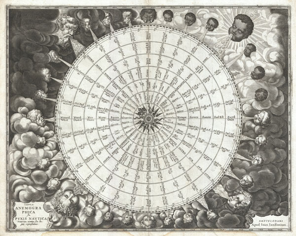
An exceptionally rare example of one of the earliest and most significant anemographic, or wind rose, charts to appear in the 17th century. This unusual chart represents a transitional point in the perception of direction, or to be precise, the transition from the wind rose to the compass rose. Early mariners in the Mediterranean defined direction by the names the various winds and the points from which they blew. This idea traces its roots to ancient Greece. Homer identified four cardinal winds, but as navigation and cartography advanced, more were added. This chart represents a full thirty-two named winds and a multitude of different wind systems. Each of the winds is identified by several different names in Greek, Latin, French, and Dutch. Each wind is additionally attached to both contemporary compass points, north west east and south, and a more sophisticated circle and degree system. In the areas surrounding the sphere, each wind is personified by a figure bearing the racial characteristics associated with the region or direction represented. The upper left quadrant, representing north, depicts bearded Germans or Scandinavians. The upper right, representing east, shows beardless dark skinned faces. The beardless and pale skinned figures in the lower left and right, representing west and south, are less distinguishable but may be intended to represent indigenous Americans and Greeks.
Anemographic charts, like this, were functional objects and valuable reference tools. Early navigators, referring to the directions as winds, might 'sail by the north wind.' This was exceptionally practical when trade winds dictated ocean commerce. A warm wind from the south, for example might suggest that certain routes, closed for part of the year, were now open. A navigator would have used this chart to compare different names for directions. So, he may be using a chart made in Greece that identified the winds by the names of Greek gods, but himself been trained to use to a different, say Catalan or English, nomenclature. With this chart, he could figure out what various sailing logs and navigation books were referring to. Remember, while nautical charts did exist in the 1600s, most navigation was accomplished using 'Pilot Books' that had instructions like this 'follow the south wind for 3 days before turning with the eastern wind' etc. Thus this was a very useful object indeed.
This chart was published as plate 1 in Jansonnius' 1650 Atlas Maritimus or volume 5 in his Atlantis Majoris.
Cartographer
Jan Jansson or Johannes Janssonius (1588 - 1664) was born in Arnhem, Holland. He was the son of a printer and bookseller and in 1612 married into the cartographically prominent Hondius family. Following his marriage he moved to Amsterdam where he worked as a book publisher. It was not until 1616 that Jansson produced his first maps, most of which were heavily influenced by Blaeu. In the mid 1630s Jansson partnered with his brother-in-law, Henricus Hondius, to produce his important work, the eleven volume Atlas Major. About this time, Jansson's name also begins to appear on Hondius reissues of notable Mercator/Hondius atlases. Jansson's last major work was his issue of the 1646 full edition of Jansson's English Country Maps. Following Jansson's death in 1664 the company was taken over by Jansson's brother-in-law Johannes Waesberger. Waesberger adopted the name of Jansonius and published a new Atlas Contractus in two volumes with Jansson's other son-in-law Elizée Weyerstraet with the imprint 'Joannis Janssonii haeredes' in 1666. These maps also refer to the firm of Janssonius-Waesbergius. The name of Moses Pitt, an English map publisher, was added to the Janssonius-Waesbergius imprint for maps printed in England for use in Pitt's English Atlas. More by this mapmaker...
Source
Jansson, J., Atlantis majoris quinta pars, orbem maritimum seu omnium marium orbis terrarium…, c. 1650.
Condition
Very good. A couple of extremely minor worm holes, top center. Minor margin wear. Original centerfold. A couple of minor older creases. Minor marginal dampstaining - bottom left and right margins.
References
Koeman, C., Atlantes Neerlandici,Me 164, 1. Van der Krogt, P. (Atlantes), volume 1, page 426. Putman, R., Eary Sea Charts, plate 6. Van der Krogt, P. C. J., Koeman's Atlantes Neerlandici, P-Rose-1.