1888 Pierre / Pfister Manuscript Map of Anhui Province, China
Anhui-pierresj-1888$4,500.00

Title
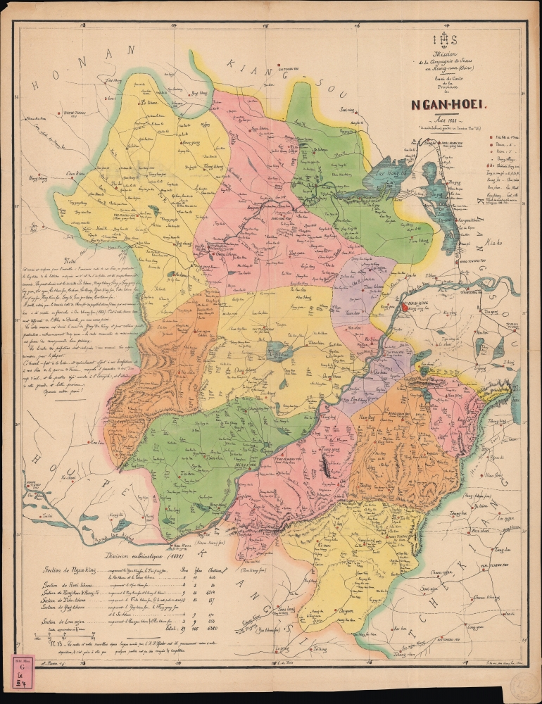
Essai de carte de la Province du Ngan-Hoei.
1888 (dated) 23 x 18.5 in (58.42 x 46.99 cm)
1888 (dated) 23 x 18.5 in (58.42 x 46.99 cm)
Description
A unique 1888 Jesuit missionary manuscript map of Anhui Province in China, produced by the Mission du Kiang-nan, Xujiahui (Zi-Ka-Wei), Shanghai.
The presence of Catholic congregations is also noted with different symbols depending on size. A glossary at right below the legend explains Chinese terms often found in placenames. Aside from settlements, rivers, lakes, roads, and other features are also recorded. The Yangtze River cuts diagonally across the map, while the Grand Canal is traced in a thick black line at right. At bottom-left is a table of statistics for the mission, including the number of priests, churches, and believers (the Jesuits were excellent record-keepers).
A note at left refers to the maps of early modern Jesuits, namely Jean-Baptiste du Halde, who, despite having never traveled to China, collected reports and other information from the missionaries to write a highly detailed description of the Qing empire, which Jean-Baptiste Bourguignon d'Anville adapted into the most advanced European map of China of the 18th century. D'Anville's map continued to be the 'gold standard' map of China in the West into the 19th century.
Although formally based in Nanjing, the Jesuits and other Catholic mission orders used Shanghai as an administrative and financial hub (the Jesuits owned considerable amounts of land in the city). The Jesuit compound at Xujiahui (Zikawei), built on the estate of the high-level Catholic Ming official Xu Guangqi (1562 - 1633) on the outskirts of Shanghai, was known worldwide as a center of missionary and intellectual activity. Among its accomplishments were some of the earliest and best translations of Chinese classical texts and Qing legal codes, alongside translations into Chinese of Western scientific texts. Although the French Jesuits managed the mission, Jesuits and missionaries from other Catholic orders of many nationalities spent time at Xujiahui or elsewhere in the mission. In the early 20th century, due to financial and personnel difficulties caused by the World War I (1914 - 1918) much of the territory seen here was delegated to Spanish and Italian Jesuits. With deep roots in a region dominated by treaty ports, especially Shanghai, the Kiang-Nan mission was well-protected and suffered few of the anti-foreign attacks that marked missionary work elsewhere in China. The thriving mission ended abruptly soon after 1949 with the establishment of the People's Republic of China.
A Closer Look
The map displays Anhui Province, just west of Nanjing, essentially half (along with Jiangsu) of the historic Chinese province of Jiangnan from which the Jesuit mission took its name. Portions of the neighboring provinces of Jiangsu (Kiang-Sou), Zhejiang (Tche-Kiang), Hubei (Hou-Pé), and Henan (Ho-Nan) are also included. Prefectures are color-shaded with prefectural capitals (fou 府, conceptually translated as 'first order cities') noted with red squares, departmental seats (tcheou 州) and county seats (hien 縣) with red circles, and villages (boung, most likely 鄉) with black circles.The presence of Catholic congregations is also noted with different symbols depending on size. A glossary at right below the legend explains Chinese terms often found in placenames. Aside from settlements, rivers, lakes, roads, and other features are also recorded. The Yangtze River cuts diagonally across the map, while the Grand Canal is traced in a thick black line at right. At bottom-left is a table of statistics for the mission, including the number of priests, churches, and believers (the Jesuits were excellent record-keepers).
A note at left refers to the maps of early modern Jesuits, namely Jean-Baptiste du Halde, who, despite having never traveled to China, collected reports and other information from the missionaries to write a highly detailed description of the Qing empire, which Jean-Baptiste Bourguignon d'Anville adapted into the most advanced European map of China of the 18th century. D'Anville's map continued to be the 'gold standard' map of China in the West into the 19th century.
The Jesuits' Kiang-Nan Mission
Based in Nanjing, the Kiang-nan Mission was established by Jesuits in the lower Yangtze River region of China in the Ming Dynasty, encompassing areas around modern-day Shanghai and Jiangsu province. During the 19th century, amidst the backdrop of the Qing Dynasty and increasing Western influence, Jesuits of the Paris Province in Kiang-Nan worked not only to spread Christianity but also to engage in cultural exchanges. Known for their educational and cultural approach, Jesuit missionaries contributed to scientific and intellectual advancements by introducing Western sciences, mathematics, and astronomy while learning from Chinese cultural and philosophical traditions.Although formally based in Nanjing, the Jesuits and other Catholic mission orders used Shanghai as an administrative and financial hub (the Jesuits owned considerable amounts of land in the city). The Jesuit compound at Xujiahui (Zikawei), built on the estate of the high-level Catholic Ming official Xu Guangqi (1562 - 1633) on the outskirts of Shanghai, was known worldwide as a center of missionary and intellectual activity. Among its accomplishments were some of the earliest and best translations of Chinese classical texts and Qing legal codes, alongside translations into Chinese of Western scientific texts. Although the French Jesuits managed the mission, Jesuits and missionaries from other Catholic orders of many nationalities spent time at Xujiahui or elsewhere in the mission. In the early 20th century, due to financial and personnel difficulties caused by the World War I (1914 - 1918) much of the territory seen here was delegated to Spanish and Italian Jesuits. With deep roots in a region dominated by treaty ports, especially Shanghai, the Kiang-Nan mission was well-protected and suffered few of the anti-foreign attacks that marked missionary work elsewhere in China. The thriving mission ended abruptly soon after 1949 with the establishment of the People's Republic of China.
The Battle for Souls in Anhui
Although the Jesuits had a presence in Nanjing (Nan-king) from the earliest days of their mission in China proper, and long-established families of Catholics were present in neighboring Jiangsu Province, the Catholic presence in Anhui was historically much more limited (numbering 6,380 Christians here). Thus, missionaries were mostly entering a terra incognita in the mid-late 19th century. This encounter often caused consternation, if not outright opposition, by the local Chinese gentry, and several incidents involving missionaries (known in Chinese as jiao'an 教案) led to disputes and even violence, including missionaries, Chinese priests, and Chinese Catholics killed and churches burned to the ground. As a result, both the Qing government and the French Legation (which was the appointed protector of all Catholic missionaries in China, later expanded to include all Catholics, including Chinese Catholics) became involved, with the French usually successfully pressing for the Qing to provide protection and pay reparations to the Jesuit mission, which even further incensed the local gentry.Recovery from the Taiping Rebellion
Anhui, and southern Anhui in particular, had been completely changed by the rebellion of the Taiping Heavenly Kingdom (1851 - 1864), which was headquartered at nearby Nanjing. Aside from battles, requisitioning of grain and labor, famine, and refugees greatly impacted the region, changing its population and culture. A decisive battle occurred at Anqing (Ngan-K'ing) in September 1861, following a year-long siege of the city by Qing troops under Zeng Guofan and his brother Zeng Guoquan. Anqing was the key to control of the Yangtze River. After its capture, Zeng made the city his headquarters, preparing an assault on the Taiping capital at Nanjing, which was finally taken in July 1864.Provenance
The map bears two library stamps, confirming it was deaccessioned by a German Jesuit library sometime in the 1980s. The library stamp remains on the lower left, and its mark appears on the lower right. It is difficult to decipher but reads 'Prov. Germ. S. J.', resolvable to 'Provinciae Germaniae Bibliotheca Scriptorum Societatis Jesu', perhaps located in Cologne. We have seen numerous other maps with the same stamps, all very rare, many unique manuscripts, so the deaccession must have been significant. A German dealer acquired the deaccessioned maps, and pieces with similar marks occasionally appear on the market, representing all parts of the world.Publication History and Census
This manuscript map was prepared in Xujiahui by Auguste Pierre, a Jesuit of the Kiang-nan mission, in 1888, relying on the earlier work of Aloys Pfister. Surviving examples are held by the Bibliothèque Nationale de France and the University of Alberta, suggesting that Jesuits produced a small number of this manuscript map for distribution within the order.CartographerS
Auguste Pierre, S.J. (1856 - 1910) was a French Jesuit of the Kiang-nan (Jiangnan) mission, based in Shanghai and operating in the surrounding region. He was involved in the production of a highly-detailed 1888 map of Anhui Province and also wrote articles for various Jesuit publications in French and English. He arrived in China in 1875 and was initially based in Guangdong before moving to Jiangnan. More by this mapmaker...
Aloys Pfister (April 24, 1833 - May 17, 1891), also known as Louis Pfister, or in China, Fei Lai Zhi (費賴之) was a French Jesuit missionary, priest, historian, and sinologist active in the Shanghai region, China. Pfister was born in Gerbeviller, Meurthe, France. He joined the Society of Jesus in 1852, after which, in 1867, he was sent to the Kiang-non Mission. Within that mission he spent many years ministering to the inhabitants of Hai-men (海门), and the alluvial island of Chongming (崇明岛). Although he had many converts, he did not consider himself successful relative to the overall population. In 1881, he retired to the mission house and library at Xujiahui Library (Zi-ka-wei), southwest of Shanghai. He remained there until 1889, when in failing health, he moved to Shanghai. There in 1891, he died of heart disease. He is best known for this Notices biographiques et bibliographiques sur les Jésuites de l'ancienne mission de Chine. 1552–1773, a history of early Jesuit missionary work in China. Learn More...
Xujiahui Library (1847 - Present), today known as the Shanghai Library Bibliotheca Zi-Ka-Wei (上海图书馆徐家汇藏书楼) was established in 1847. It was initially part of the Jesuit mission complex in the Xujiahui village (徐家汇), situated on the outskirts of Shanghai. Following the Jesuit mission of scholarship, it evolved into an academic center embracing both Chinese and Western academic heritages. It was also an important publishing house, issuing maps, religious works, scholarly studies, and more. By the end of the 19th century, it housed over 200,000 volumes. The library is known for its comprehensive collection of Chinese gazetteers, newspapers, reference materials, and mission-related publications. The establishment of the People's Republic of China marked the end of the Jesuit mission in Xujiahui. Nonetheless, the library perseveres, having been nationalized and, from 1957, integrated into the Shanghai Library System. Learn More...
Condition
Very good. Light wear along original folds. Several small tears along border professionally repaired.
References
OCLC 494928523, 705241912.