This item has been sold, but you can get on the Waitlist to be notified if another example becomes available, or purchase a digital scan.
1809 Dirección Hidrografía Map of Central America, Colombia, Venezuela
AntillesTierraFirme-hidrografia-1809$350.00

Title
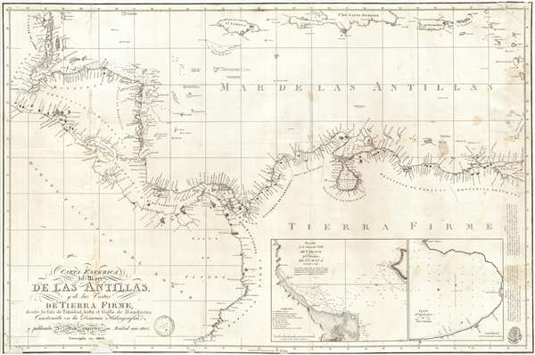
Carta Esferica del Mar de Las Antillas y de la Costas de Tierra Firme, desde la Isla de Trinidad, hasta el Golfo de Honduras Construida en la Direccion Hidrografica y pubicada de orden superior en Mardrid ano 1805.
1809 (dated) 23 x 35.25 in (58.42 x 89.535 cm) 1 : 3700000
1809 (dated) 23 x 35.25 in (58.42 x 89.535 cm) 1 : 3700000
Description
A rare Spanish Dirección de Hidrografía 1809 nautical chart or maritime map of the coasts of Central America, Colombia, and Venezuela. The map covers from the Gulf of Honduras to Panamá and Maracaibo. In extends north to include the island of Jamaica as well as parts of Puerto Rico, Guadeloupe, and Santo Domingo (Hispaniola). In includes Nicaragua, Veraguas, Venezuela, Caracas, and Cumaná; Governments of Cartagena and St. Marta. Insets detail Cumana (Venezuela) and Truxillo. Soundings throughout.
The map was drawn by Miguel Moreno (fl. 1805 – 1838) and engraved by J. Morata (fl. 1792-1817). Published by the Dirección de Hidrografía in 1805 and, again, as here, 1809. The OCLC list only 2 known examples, in the University of Texas at Arlington and in the archives of the Biblioteca Nacional de España.
The map was drawn by Miguel Moreno (fl. 1805 – 1838) and engraved by J. Morata (fl. 1792-1817). Published by the Dirección de Hidrografía in 1805 and, again, as here, 1809. The OCLC list only 2 known examples, in the University of Texas at Arlington and in the archives of the Biblioteca Nacional de España.
Cartographer
The Direccion Hidrografía (1787 - 1927), also known as the Deposito Hydrografico and the Direction de Hidrografía, was the Spanish equivalent of the British Admiralty or the U.S. Coast Survey. This organization, founded in 1787, was commissioned to collect and produce accurate nautical charts of all waters frequented by Spanish vessels. In essence, it replaced the Casa de la Contratación de las Indias (House of Trade of the Indies), which closed its doors in 1790. Like most such organizations, the Direccion Hidrografía marked a new age in cartography. Rather than simply collect charts created by navigators, explorers, and merchants, the Direccion Hidrografía worked closely with naval and military personnel to mount cartographic and hydrographic expeditions in pursuit of the most accurate hydrographical, astronomical, and geodetic measurements. The Direccion Hidrografía created a massive library of nautical charts that, though not nearly as common as similar nautical charts by the U.S. Coast Survey and British Admiralty, are highly desirable for the beauty of their manufacture as well as their accuracy and detail. The office was originally located on Calle Ballesta, but relocated to 36 Alcala, both in Madrid. After 1908 the Dirección was subsumed into other governmental agencies. In 1927 the Direccion was absorbed into the Institute and Observatory of San Fernando, located in Cadiz. The library of original maps, charts, and journals was transferred to the Naval Museum of Madrid - where it resides to this day. More by this mapmaker...
Condition
Good. Map has some discoloration and verso repairs including slight repaired loss at borders. Backed on archival tissue. Trimmed to neatline.
References
OCLC 618536522.