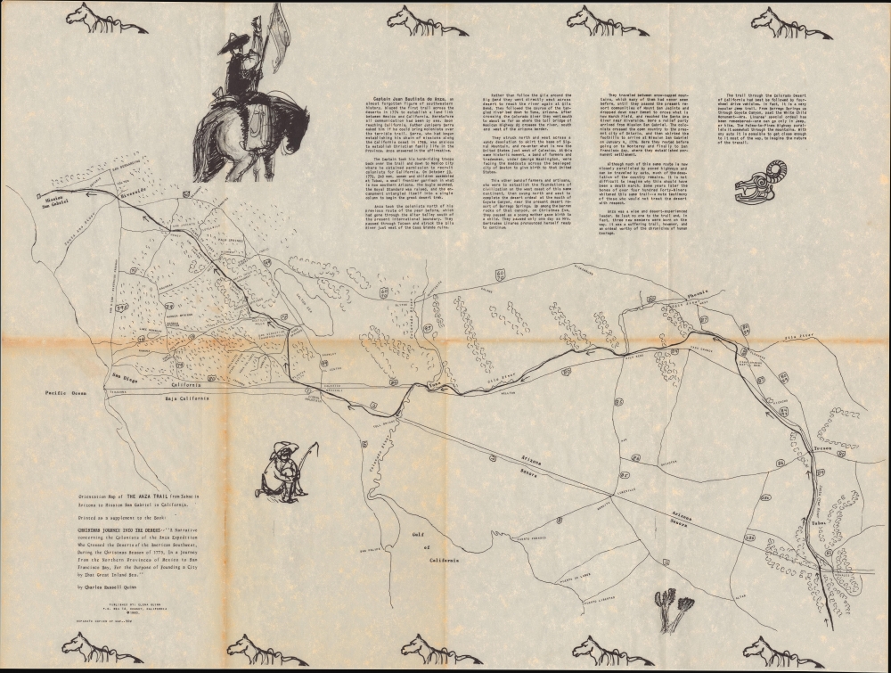
Title
Orientation Map of the Anza Tail from Tubac to Mission San Gabriel in California.
1960 (dated)
18.75 x 24.75 in (47.625 x 62.865 cm)
1 : 1200000
Description
This is a 1960 Charles Russell Quinn historical map of the Anza Trail in Arizona and Southern California, prepared for his book Christmas Journey into the Desert.
A Closer Look
This curious map has a sketch-like, hand-drawn quality despite being printed. Covering from Southern California (Los Angeles area) to Nogales on the Arizona-Mexico border, with some coverage of the Mexican side of the borderlands, it traces the route of the expeditions of Juan Bautista de Anza in 1774-1776 (described in the text at top-right and discussed below). The map superimposes modern borders, cities, and highways on the landscape traversed by de Anza, to emphasize that modern travelers largely use the same route traveled by the Spanish colonists. Illustrations around the map, including of a horseback Spaniard and the skull of a cattle, add to its charm.The Travels of Juan Bautista de Anza
Juan Bautista de Anza's first California journey in 1774 was an expedition to establish an overland route from New Spain to Alta California. De Anza, a Spanish military officer, led the expedition from Tubac Presidio (in present-day southern Arizona, near the Mexican border city of Nogales) to Mission San Gabriel (the first European settlement near what would become Los Angeles, established in 1771). The goal was to open a reliable land passage to supply the Spanish settlements in California, particularly the presidio at Monterey. This was no small undertaking, as the geography along the route was poorly understood, and what was understood revealed that it would be extremely dangerous, crossing mostly desert terrain and a few raging rivers, including the Colorado, and encountering Indians who might not be well-disposed towards outsiders, especially the Apache, who had at best a testy relationship with the Spanish (other groups who had better relations with the Spanish proved invaluable to Anza's travels, particularly the Quechan/Yuma). The earlier 1769 Portolá Expedition, which established Alta California, traversed a mostly coastal route in order to be continually resupplied by ships, but Anza's expedition was an entirely different undertaking. Remarkably, the expedition reached the Mission San Gabriel intact, and Anza returned to Sonora via a modified route along the Gila River (shown here), faster and better supplied with fresh water than his outbound journey.
Upon returning to Tubac, Anza was immediately tasked with organizing a second, much larger expedition with soldiers and colonists, as well as several hundred cattle, which thrived in the grasslands of California, paving the way for the rancho system. More ambitious than the first, the second expedition followed his Gila River route, made it to the Mission San Gabriel, and then reached San Francisco Bay, establishing the Presidio of San Francisco and the Mission San Francisco de Asís (Mission Delores), the first non-indigenous settlement in what became San Francisco. Despite traveling for months through harsh terrain and weather over paths prone to being washed away and overcoming poor morale and resistance from members of the expedition (including servants who were understandably unenthusiastic about being 'volunteered' for such a dangerous excursion), the group managed to reach the future site of San Francisco with only one member dying, a woman in childbirth. Anza proved that an overland route to California was feasible, though far from easy - in 1781, another group of Spanish colonists was killed by the Quechan Indians who had helped Anza, but who were angered after the Spanish (who had established two missions nearby) had committed numerous offenses. In the following decades, as the Spanish launched punitive expeditions and tensions simmered, the Yuma Crossing at the Colorado River, and thus the land route to California, was effectively closed, resulting in a continued reliance on ships traveling up the coast for supplies and settlers.Publication History and Census
This map was prepared by Charles Russell Quinn for his 1960 account of the Anza expedition Christmas Journey into the Desert. It is independently cataloged among the holdings of the Arizona Historical Society and the Arizona State Museum Library and Archives, while the book is more widespread in institutional collections.
Cartographer
Charles Russell Quinn (June 20, 1907 - December 19, 1988) was a local historian of the inland desert communities of southern California, based in Downey. A native of Philadelphia, Pennsylvania, Quinn relocated to Southern California after his military service in the Second World War, living first in San Francisco, and then from 1951 in Downey. Along with Elena Quinn, his wife, he published at least six books on the history of the American Southwest, including the Anza Expedition, the Mission Santa Ysabel in San Diego County, and the history of Downey itself. More by this mapmaker...
Source
Quinn, C., Christmas journey into the desert : a narrative concerning the colonists of the Anza expedition who crossed the deserts of the American Southwest, during the Christmas season of 1775, (Downey, CA: Elena Quinn) 1960.
Condition
Very good. Wear and toning along original fold lines.
References
OCLC 35908822.