This item has been sold, but you can get on the Waitlist to be notified if another example becomes available, or purchase a digital scan.
1950 Aeronautical Chart Service Topographic Map of the Middle East
ArabiaMiddleEast-aeronautical-1950$250.00


Title
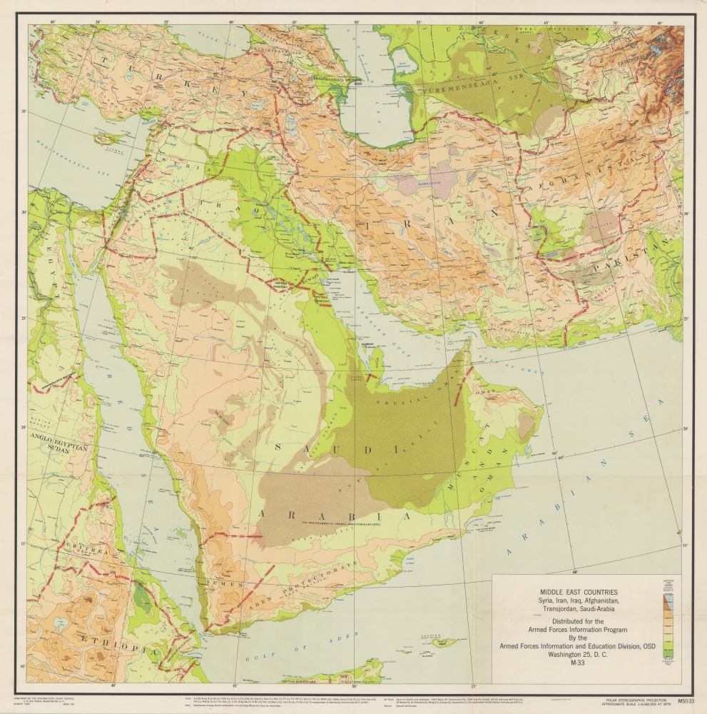
Middle East Countries. Syria, Iran, Jordan, Afghanistan, Trans-Jordan, Saudi-Arabia.
1950 (dated) 35.5 x 35.5 in (90.17 x 90.17 cm) 1 : 4040000
1950 (dated) 35.5 x 35.5 in (90.17 x 90.17 cm) 1 : 4040000
Description
A fascinating map from the early days of American involvement in the Middle East, this 1950 topographical map was produced by the U.S. Air Force's Aeronautical Chart Service. It displays the region during a period of immense change, defined by disputed borders, Communist infiltration, and the dissolution of colonial empires.
Many international borders were disputed at the time, especially on the Arabian Peninsula, where it is noted that 'All boundaries in Arabia are undemarcated'. The status of several territories also remained uncertain. Aside from Palestine (the State of Israel is not recognized here), Syria, Jordan (Trans-Jordan), and Pakistan had recently become independent states, while Eritrea and Italian Somaliland are still listed as Italian here, though they had been under British military administration since 1941.
Interestingly, Arabic transliterations are used throughout for placenames rather than more familiar English approximations, such as Makkah instead of Mecca, al-Madinah instead of Medina, Dimishq instead of Damascus, Tall Abīb for Tel Aviv, and so on. Similarly, Russian names are used for constituent soviet socialist republics of the Soviet Union (Turkmenskaya SSR, Uzbekskaya SSR, Tadzhiskaya SSR).
A Closer Look
Stretching from Turkey and Ethiopia across to Afghanistan and Pakistan, this map provides topographic detail for much of the Middle East. Cities, international borders, waterways, elevation, roads (completed and under construction), and railways are recorded. Riyadh ('Ar Riyād') appears here as a relatively small town, but would be transformed in the following months and years as it was planned and developed at the behest of King Saud.Many international borders were disputed at the time, especially on the Arabian Peninsula, where it is noted that 'All boundaries in Arabia are undemarcated'. The status of several territories also remained uncertain. Aside from Palestine (the State of Israel is not recognized here), Syria, Jordan (Trans-Jordan), and Pakistan had recently become independent states, while Eritrea and Italian Somaliland are still listed as Italian here, though they had been under British military administration since 1941.
Interestingly, Arabic transliterations are used throughout for placenames rather than more familiar English approximations, such as Makkah instead of Mecca, al-Madinah instead of Medina, Dimishq instead of Damascus, Tall Abīb for Tel Aviv, and so on. Similarly, Russian names are used for constituent soviet socialist republics of the Soviet Union (Turkmenskaya SSR, Uzbekskaya SSR, Tadzhiskaya SSR).
Historical Context
This map reflects the uncertainty in the region following the end of the World War II (1939 - 1945) and is more specifically the product of the developing relationship between the U.S. and Saudi Arabia, based on oil and security. The U.S. provided security guarantees to the Saudis and in exchange received permission to station forces and build airfields in the kingdom, providing a major asset with proximity to Iran, under threat from Soviet influence, and the Soviet Union itself. Soon after this map's publication, the world's largest onshore and offshore oil reserves were discovered in Saudi territory, and were exploited by Saudi Aramco, a joint U.S.-Saudi venture which took on its name, form (with a 50-50 profit sharing agreement), and ownership structure in the late 1940s and 1950.Publication History and Census
This map was produced by the Aeronautical Chart Service of the U.S. Air Force in 1950, for distribution by the Armed Forces Information Program. It was distributed among the various military branches as listed in the bottom margin. The map is quite rare, being listed among the holdings of the Library of Congress, Stanford University, University of California Berkeley, New Mexico State University, the University of Minnesota Twin Cities, and Duke University.Condition
Very good. light horizontal and vertical folds as issued. A few very slight handling marks but otherwise in very good condition.
References
OCLC 38401408.