This copy is copyright protected.
Copyright © 2025 Geographicus Rare Antique Maps
Digital Image: 1860 James Polar Projection of the Globe - Arctic / Atlantic Projection
ArcticProjection-james-1860_d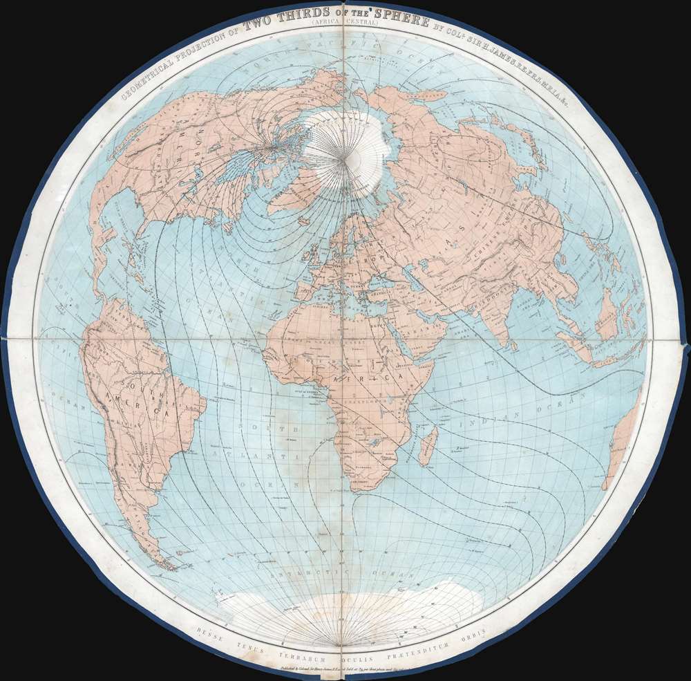

FOR THE ORIGINAL ANTIQUE MAP, WITH HISTORICAL ANALYSIS, CLICK HERE.
Digital Map Information
Geographicus maintains an archive of high-resolution rare map scans. We scan our maps at 300 DPI or higher, with newer images being 600 DPI, (either TIFF or JPEG, depending on when the scan was done) which is most cases in suitable for enlargement and printing.
Delivery
Once you purchase our digital scan service, you will receive a download link via email - usually within seconds. Digital orders are delivered as ZIP files, an industry standard file compression protocol that any computer should be able to unpack. Some of our files are very large, and can take some time to download. Most files are saved into your computer's 'Downloads' folder. All delivery is electronic. No physical product is shipped.
Credit and Scope of Use
You can use your digial image any way you want! Our digital images are unrestricted by copyright and can be used, modified, and published freely. The textual description that accompanies the original antique map is not included in the sale of digital images and remains protected by copyright. That said, we put significant care and effort into scanning and editing these maps, and we’d appreciate a credit when possible. Should you wish to credit us, please use the following credit line:
Courtesy of Geographicus Rare Antique Maps (http://www.geographicus.com).
How Large Can I Print?
In general, at 300 DPI, you should at least be able to double the size of the actual image, more so with our 600 DPI images. So, if the original was 10 x 12 inches, you can print at 20 x 24 inches, without quality loss. If your display requirements can accommodate some loss in image quality, you can make it even larger. That being said, no quality of scan will allow you to blow up at 10 x 12 inch map to wall size without significant quality loss. For more information, it is best consult a printer or reprographics specialist.
Refunds
If the high resolution image you ordered is unavailable, we will fully refund your purchase. Otherwise, digital images scans are a service, not a tangible product, and cannot be returned or refunded once the download link is used.
Sir Henry James (1803 - 1877) was the director-general of the Ordnance Survey, the mapping agency of the British government, from 1854 to 1875. He studied at the Royal Military Academy and was commissioned as a second lieutenant in the Royal Engineers on September 22, 1826. He joined the Ordnance Survey in 1827 and spent the majority of his career there, except for a brief stint at the Admiralty. He became Superintendent of the Ordnance Survey in 1854. Upon taking over the Ordnance Survey, he became involved in the 'battle of the scales'. It had long been debated which maps should be made and what scale would be the most useful. Sir Henry was a firm believer in the 1 : 2500 scale, and, due to his position, imposed this belief upon the Survey despite the less than full approval of his superiors. Sir Henry created a photography department at the Ordnance Survey in 1855 as a means of reducing the scale of maps. He claimed to have invented photozincography, a photographic method of producing printing plates. However, the process had in fact been developed by two members of his staff. Nonetheless, James was the driving force behind using the process to create and publish a facsimile of the Domesday Book in the 1860s. He also used this photozincographic process to preserve historic manuscripts. More by this mapmaker...
Copyright © 2025 Geographicus Rare Antique Maps | Geographicus Rare Antique Maps
This copy is copyright protected.
Copyright © 2025 Geographicus Rare Antique Maps